
Charleston is the capital and most populous city of the U.S. state of West Virginia and the seat of Kanawha County. Located at the confluence of the Elk and Kanawha rivers, the city had a population of 48,864 at the 2020 census and an estimated population of 48,018 in 2021. The Charleston metropolitan area had 210,605 residents in 2020.
Interstate 79 (I-79) is an Interstate Highway in the Eastern United States, designated from I-77 in Charleston, West Virginia, north to Pennsylvania Route 5 (PA 5) and PA 290 in Erie, Pennsylvania. It is a primary thoroughfare through western Pennsylvania and West Virginia and makes up part of an important corridor to Buffalo, New York, and the Canada–United States border. Major metropolitan areas connected by I-79 include Charleston and Morgantown in West Virginia and Greater Pittsburgh and Erie in Pennsylvania.

Interstate 64 (I-64) is an east–west Interstate Highway in the Eastern United States. Its western terminus is at I-70, U.S. Route 40 (US 40), and US 61 in Wentzville, Missouri. Its eastern terminus is at the Bowers Hill Interchange with I-264 and I-664 at Bower's Hill in Chesapeake, Virginia. I-64 connects Greater St. Louis, the Louisville metropolitan area, the Lexington–Fayette metropolitan area, the Charleston metropolitan area, the Greater Richmond Region, and Hampton Roads.

Huntington is a city in Cabell and Wayne counties in the U.S. state of West Virginia. The county seat of Cabell County, the city is located at the confluence of the Ohio and Guyandotte rivers. Huntington is the second-most populous city in West Virginia, with a population of 46,842 as of the 2020 census. Its metro area, the Huntington–Ashland metropolitan area, is the largest in West Virginia, spanning seven counties across three states and having a population of 376,155 at the 2020 census.

South Charleston is a city in Kanawha County, West Virginia, United States. It is located to the west of the state capital of Charleston. The population was 13,639 at the 2020 census. It was established in 1906, but not incorporated until 1917. The Criel Mound built circa 0 BCE by the Adena culture is adjacent to the city's downtown business district.

The Pacific Electric Railway Company, nicknamed the Red Cars, was a privately owned mass transit system in Southern California consisting of electrically powered streetcars, interurban cars, and buses and was the largest electric railway system in the world in the 1920s. Organized around the city centers of Los Angeles and San Bernardino, it connected cities in Los Angeles County, Orange County, San Bernardino County and Riverside County.

U.S. Route 52 (US 52) is a major United States highway in the central United States that extends from the northern to southeastern region of the United States. Contrary to most other even-numbered U.S. Highways, US 52 primarily follows a northwest–southeast route, and is signed north–south or east–west depending on the local orientation of the route. The highway's northwestern terminus is in Portal, North Dakota at the Canada–United States border, where it continues as Saskatchewan Highway 39. Its southeastern terminus is in Charleston, South Carolina, at Number 2 Meeting Street and White Point Garden along the Charleston Harbor.

Transportation in the Commonwealth of Virginia is by land, sea and air. Virginia's extensive network of highways and railroads were developed and built over a period almost 400 years, beginning almost immediately after the founding of Jamestown in 1607, and often incorporating old established trails of the Native Americans.

Transportation in Richmond, Virginia and its immediate surroundings include land, sea and air modes. This article includes the independent city and portions of the contiguous counties of Henrico and Chesterfield. While almost all of Henrico County would be considered part of the Richmond area, southern and eastern portions of Chesterfield adjoin the three smaller independent cities of Petersburg, Hopewell, and Colonial Heights, collectively commonly called the Tri-Cities area. A largely rural section of southwestern Chesterfield may be considered not a portion of either suburban area.

A large metropolitan area that is surrounded by rivers and hills, Pittsburgh has an infrastructure system that has been built out over the years to include roads, tunnels, bridges, railroads, inclines, bike paths, and stairways; however, the hills and rivers still form many barriers to transportation within the city.

U.S. Route 60 (US 60) runs northwest to southeast across the central and southern portions of West Virginia. It runs from the Kentucky state line at Catlettsburg, Kentucky, and Kenova. The road passes through Huntington, Charleston, and White Sulphur Springs. The route exits the state into Virginia, running concurrently with Interstate 64 (I-64) east of White Sulphur Springs. Most of US 60's route through West Virginia is part of and even signed in several areas as the Midland Trail, a National Scenic Byway.

Interstate 77 (I-77) in the US state of West Virginia is a major north–south Interstate Highway. It extends for 187.21 miles (301.29 km) between Bluefield at the Virginia state line and Williamstown at the Ohio state line.

Interstate 64 (I-64) is an Interstate Highway in the US state of West Virginia. It travels east–west through the state for 189 miles (304 km) passing by the major towns and cities of Huntington, Charleston, Beckley, and Lewisburg.
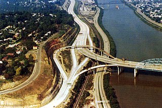
The roads of Charleston, West Virginia, include three major interstate highways, several U.S. highways and state routes, and numerous major thoroughfares.
Stone & Thomas was a United States chain of department stores. Based in Wheeling, West Virginia, the chain had stores located in West Virginia, Virginia, Kentucky, and Ohio. The company was bought out in 1998 by Elder-Beerman, an Ohio-based chain of department stores.
Transportation in Erie, Pennsylvania includes access to most major forms of transportation, including automobile, bus, train, taxi, airplane, and ship. The city generates income through the transportation industry, including train manufacturing and port operations.

Historically, the harbor was the key to the Hampton Roads area's growth, both on land and in water-related activities and events. Ironically, the harbor and its tributary waterways were both important transportation conduits and obstacles to other land-based commerce and travel. For hundreds of years, state and community leaders have worked to develop solutions to accommodate both.

The Tri-State Transit Authority (TTA) is the city bus system in Huntington, West Virginia, and Ironton, Ohio, as well as its suburbs. Its buses range, on the West Virginia side from 21st Street in Kenova, WV to Milton, West Virginia, about 20 miles to the east. On the Ohio side the buses range from downtown Ironton to the Huntington suburb of Proctorville, Ohio, which is also a range of about 20 miles. Interchange buses provide links between Huntington and Chesapeake, Ohio, and between Ironton and Ashland, Kentucky, where transfers are available to the Ashland Bus System (ABS). However the system does not interchange between the TTA and ABS in Ceredo, West Virginia, even though the buses pass within a few blocks of one another.
The Kanawha Valley Regional Transportation Authority, commonly known as "KRT" is the city bus system for the Charleston, West Virginia, United States metropolitan area.