Related Research Articles

A tsunami is a series of waves in a water body caused by the displacement of a large volume of water, generally in an ocean or a large lake. Earthquakes, volcanic eruptions and other underwater explosions above or below water all have the potential to generate a tsunami. Unlike normal ocean waves, which are generated by wind, or tides, which are in turn generated by the gravitational pull of the Moon and the Sun, a tsunami is generated by the displacement of water from a large event.

A natural disaster is the highly harmful impact on a society or community following a natural hazard event. Examples of natural hazard events include floods, droughts, earthquakes, tropical cyclones, volcanic activity, wildfires. A natural disaster can cause loss of life or damage property, and typically leaves economic damage in its wake. The severity of the damage depends on the population's disaster preparedness and on the existing infrastructure. Scholars have been saying that the term natural disaster is unsuitable and should be abandoned. Instead, the simpler term disaster could be used, while also specifying the category of hazard. A disaster is a result of a natural or human-made hazard impacting a vulnerable community. It is the combination of the hazard along with exposure of a vulnerable society that results in a disaster.
The Intergovernmental Oceanographic Commission of UNESCO (IOC/UNESCO) was established by resolution 2.31 adopted by the General Conference of the United Nations Educational, Scientific and Cultural Organization (UNESCO). It first met in Paris at UNESCO Headquarters from 19 to 27 October 1961. Initially, 40 States became members of the commission. The IOC assists governments to address their individual and collective ocean and coastal management needs, through the sharing of knowledge, information and technology as well as through the co-ordination of programs and building capacity in ocean and coastal research, observations and services.
The Caribbean Disaster Emergency Management Agency (CDEMA) is an inter-regional supportive network of independent emergency units throughout the Caribbean region. Formed on September 1, 2005, as the Caribbean Disaster Emergency Response Agency (CDERA), it underwent a name change to CDEMA in September 2009.
The Volcano Disaster Assistance Program (VDAP) was developed by the U.S. Geological Survey and the United States Agency for International Development's Office of U.S. Foreign Disaster Assistance after the eruption of Nevado del Ruiz (Colombia) in 1985. The volcanic eruption melted a glacier triggering a lahar that killed 25,000 people. It was determined that increased monitoring and enhanced communications between scientists and civil authorities would make it easier to evacuate local populations and save lives. Today the program responds to volcanic crises around the world. The aim of the program is to assist in saving lives and property, to reduce economic losses, and to prevent a natural hazard becoming a natural disaster. VDAP staff members are based at the USGS Cascades Volcano Observatory, in Vancouver, Washington. VDAP channels its energy into four main activities: response to natural disaster, capacity building, training, and volcanological research.

The 1970 Bhola cyclone was a devastating Tropical Cyclone that struck East Pakistan and India's West Bengal on November 12, 1970. It remains the deadliest tropical cyclone ever recorded and one of the world's deadliest humanitarian disasters. At least 300,000 people died in the storm, possibly as many as 500,000, primarily as a result of the storm surge that flooded much of the low-lying islands of the Ganges Delta. Bhola was the sixth and strongest cyclonic storm of the 1970 North Indian Ocean cyclone season.

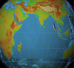
On 26 December 2004, at 07:58:53 local time (UTC+7), a major earthquake with a magnitude of 9.2–9.3 Mw struck with an epicentre off the west coast of northern Sumatra, Indonesia. The undersea megathrust earthquake, known by the scientific community as the Sumatra–Andaman earthquake, was caused by a rupture along the fault between the Burma Plate and the Indian Plate, and reached a Mercalli intensity up to IX in some areas.

A tsunami warning system (TWS) is used to detect tsunamis in advance and issue the warnings to prevent loss of life and damage to property. It is made up of two equally important components: a network of sensors to detect tsunamis and a communications infrastructure to issue timely alarms to permit evacuation of the coastal areas. There are two distinct types of tsunami warning systems: international and regional. When operating, seismic alerts are used to instigate the watches and warnings; then, data from observed sea level height are used to verify the existence of a tsunami. Other systems have been proposed to augment the warning procedures; for example, it has been suggested that the duration and frequency content of t-wave energy is indicative of an earthquake's tsunami potential.
Tilly Smith is a British woman who, as a child, was credited with saving the lives of approximately 100 beachgoers at Mai Khao Beach in Thailand by warning them minutes before the arrival of the tsunami caused by the 2004 Indian Ocean earthquake. Smith, who was ten years old at the time, had learned about tsunamis in her geography class.
The World Conference on Disaster Risk Reduction is a series of United Nations conferences focusing on disaster and climate risk management in the context of sustainable development. The World Conference has been convened three times, with each edition to date having been hosted by Japan: in Yokohama in 1994, in Hyogo in 2005 and in Sendai in 2015. As requested by the UN General Assembly, the United Nations Office for Disaster Risk Reduction (UNDRR) served as the coordinating body for the Second and Third UN World Conference on Disaster Reduction in 2005 and 2015.
The Indian Ocean Tsunami Warning System was set up to provide warning to inhabitants of nations bordering the Indian Ocean of approaching tsunamis. The tsunami warning system has been in use since the mid-2000s.

An emergency population warning is a method where by local, regional, or national authorities can contact members of the public to warn them of an impending emergency. These warnings may be necessary for a number of reasons, including:

An early warning system is a warning system that can be implemented as a chain of information communication systems and comprises sensors, event detection and decision subsystems for early identification of hazards. They work together to forecast and signal disturbances that adversely affect the stability of the physical world, providing time for the response system to prepare for the adverse event and to minimize its impact.
Pacific Disaster Center (PDC) is an applied science, information and technology center, working to reduce disaster risks and impacts on life, property, and the economies worldwide.
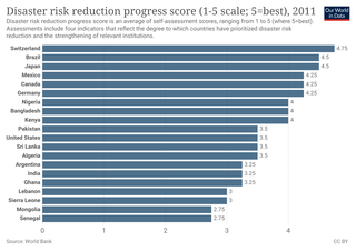
Disaster risk reduction (DRR) is an approach for planning and taking steps to make disasters less likely to happen, and less damaging when they do happen. DRR aims to make communities stronger and better prepared to handle disasters. When DRR is successful, it decreases the vulnerability of communities because it mitigates the effects of disasters. This means DRR can reduce the severity and number of risky events. Since climate change can increase climate hazards, DRR and climate change adaptation are often looked at together in development efforts.

Extremely Severe Cyclonic Storm Nargis was an extremely destructive and deadly tropical cyclone that caused the worst natural disaster in the recorded history of Myanmar during early May 2008. The cyclone made landfall in Myanmar on Friday, 2 May 2008, sending a storm surge 40 kilometres up the densely populated Irrawaddy delta, causing catastrophic destruction and at least 138,373 fatalities. The Labutta Township alone was reported to have 80,000 dead, with about 10,000 more deaths in Bogale. There were around 55,000 people missing and many other deaths were found in other towns and areas, although the Myanmar government's official death toll may have been under-reported, and there have been allegations that government officials stopped updating the death toll after 138,000 to minimise political fallout. The feared 'second wave' of fatalities from disease and lack of relief efforts never materialised. Damage was at $12 billion, making Nargis the costliest tropical cyclone on record in the North Indian Ocean at the time, before that record was broken by Cyclone Amphan in 2020.
Although National Oceanic and Atmospheric Administration (NOAA) scientists at the Pacific Tsunami Warning Center (PTWC) in Hawaii eventually issued warnings of a possible tsunami from the large earthquake off Sumatra, the waves outran notification systems at jet speeds of 500 mph (804 km/h), catching hundreds of thousands of people unaware. The following is a timeline of the 2004 Indian Ocean earthquake. All times are Coordinated Universal Time (UTC), on Sunday, 26 December 2004.
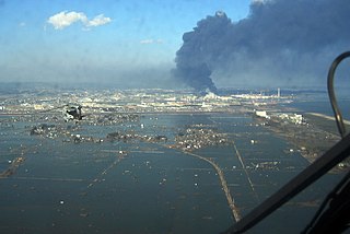
On 11 March 2011, at 14:46 JST, a Mw 9.0–9.1 undersea megathrust earthquake occurred in the Pacific Ocean, 72 km (45 mi) east of the Oshika Peninsula of the Tōhoku region. It lasted approximately six minutes and caused a tsunami. It is sometimes known in Japan as the "Great East Japan Earthquake", among other names. The disaster is often referred to by its numerical date, 3.11.

The United Nations Office for Disaster Risk Reduction (UNDRR) was created in December 1999 to ensure the implementation of the International Strategy for Disaster Reduction.
Building Back Better, or more frequently termed Build Back Better (BBB), is a strategy aimed at reducing the risk to the people of nations and communities in the wake of future disasters and shocks. It is a conceptual strategy that has continued to evolve since its origination in May 2005. However, what continues is the overall goal of enabling countries and communities to be stronger and more resilient following a disaster by reducing vulnerability to future disasters. Building resilience entails addressing physical, social, environmental, and economic vulnerabilities and shocks.
References
- ↑ "Statement at the Plenary Session of the World Conference on Disaster Reduction" (PDF). www.unisdr.org. Retrieved 2024-06-20.
- ↑ "CrissCross". www.crisscross.com. Archived from the original on 21 November 2008. Retrieved 18 August 2022.