
Interstate 90 (I-90) is an east–west transcontinental freeway and the longest Interstate Highway in the United States at 3,021 miles (4,862 km). It begins in Seattle, Washington, and travels through the Pacific Northwest, Mountain West, Great Plains, Midwest, and the Northeast, ending in Boston, Massachusetts. The highway serves 13 states and has 15 auxiliary routes, primarily in major cities such as Chicago, Cleveland, Buffalo, and Rochester.

Lake Washington is a large freshwater lake adjacent to the city of Seattle, Washington, United States. It is the largest lake in King County and the second largest natural lake in the state of Washington, after Lake Chelan. It borders the cities of Seattle on the west, Bellevue and Kirkland on the east, Renton on the south, and Kenmore on the north, and encloses Mercer Island. The lake is fed by the Sammamish River at its north end and the Cedar River at its south.
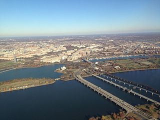
The 14th Street bridges refers to the three bridges near each other that cross the Potomac River, connecting Arlington, Virginia and Washington, D.C. Sometimes the two nearby rail bridges are included as part of the 14th Street bridge complex. A major gateway for automotive, bicycle and rail traffic, the bridge complex is named for 14th Street, which feeds automotive traffic into it on the D.C. end.

The Evergreen Point Floating Bridge, officially the Governor Albert D. Rosellini Bridge, and commonly called the SR 520 Bridge or 520 Bridge, was a floating bridge in the U.S. state of Washington that carried State Route 520 across Lake Washington, connecting Medina with the Montlake neighborhood of Seattle.

The Lacey V. Murrow Memorial Bridge is a floating bridge in the Seattle metropolitan area of the U.S. state of Washington. It is one of the Interstate 90 floating bridges that carries the eastbound lanes of Interstate 90 across Lake Washington from Seattle to Mercer Island. Westbound traffic is carried by the adjacent Homer M. Hadley Memorial Bridge.

The Delaware Memorial Bridge is a dual-span suspension bridge crossing the Delaware River. The toll bridges carry Interstate 295 and U.S. Route 40 and is also the link between Delaware and New Jersey. The bridge was designed by the firm of Howard, Needles, Tammen & Bergendoff with consulting help from engineer Othmar Ammann, whose other designs include the George Washington Bridge and the Verrazzano-Narrows Bridge.

The Ship Canal Bridge is a double-deck steel truss bridge that carries Interstate 5 (I-5) over Seattle's Portage Bay between Capitol Hill and the University District. The canal below connects Lake Union with Lake Washington. Construction was completed in 1961 and the bridge opened to traffic on December 18, 1962. It is 4,429 ft long, stands 182 feet above the canal and is 119 feet wide at the upper deck. It was the largest bridge of its kind in the Northwest when it first opened. The bridge is double-decked, with the upper deck carrying traffic in both directions and the lower deck carrying traffic southbound in the morning and northbound in the afternoon.

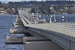
The Third Lake Washington Bridge, officially the Homer M. Hadley Memorial Bridge, is a floating bridge in the Seattle metropolitan area of the U.S. state of Washington. It is one of the Interstate 90 floating bridges, carrying the westbound lanes of Interstate 90 across Lake Washington between Mercer Island and Seattle. The floating bridge is the fifth-longest of its kind in the world, at 5,811 feet.

Interstate 395 (I-395) in Virginia and Washington, D.C., is a 13.79-mile-long (22.19 km) spur route of I-95 that begins at an interchange with I-95 in Springfield and ends at an interchange with US Route 50 (US 50) in Northwest Washington, D.C. It passes underneath the National Mall near the US Capitol and ends at a junction with US 50 at New York Avenue, roughly one mile (1.6 km) north of the 3rd Street Tunnel. Despite its proximity to I-395 in Maryland, the route is unrelated and unconnected.

Transportation in Seattle is largely focused on the automobile like many other cities in western North America; however, the city is just old enough for its layout to reflect the age when railways and trolleys predominated. These older modes of transportation were made for a relatively well-defined downtown area and strong neighborhoods at the end of several former streetcar lines, now mostly bus lines.

Transportation in the Commonwealth of Virginia is by land, sea and air. Virginia's extensive network of highways and railroads were developed and built over a period almost 400 years, beginning almost immediately after the founding of Jamestown in 1607, and often incorporating old established trails of the Native Americans.
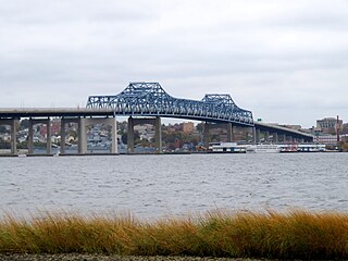
The Charles M. Braga Jr. Memorial Bridge, also known as the Braga Bridge, or simply, The Braga, is a through truss bridge that carries Interstate 195 over the Taunton River between the town of Somerset and the city of Fall River, near the mouth of the Quequechan River at the confluence with Mount Hope Bay. At just over a mile long, The Braga Bridge spans 1.25 miles (2.01 km) and is one of the longest bridges in Massachusetts. Opened to traffic on April 15, 1966, it provides an important link between Providence, Rhode Island, Fall River, New Bedford, and Cape Cod.

The Mount Baker Tunnel or Mount Baker Ridge Tunnel carries Interstate 90 under the Mount Baker neighborhood of Seattle, Washington. It is actually a group of three tubes that carry eight lanes of freeway traffic, plus a separate path for bicycles and pedestrians. The original tubes are twin tunnel bores completed in 1940 and rehabilitated in 1993. The new Mount Baker Tunnel was built north of the original tunnels and opened in June 1989. The tunnel has a double-decked roadway with the bicycle/pedestrian path above the traffic lanes.
Interstate 90 (I-90), designated as the American Veterans Memorial Highway, is a transcontinental Interstate Highway that runs from Seattle, Washington, to Boston, Massachusetts. It crosses Washington state from west to east, traveling 298 miles (480 km) from Seattle across the Cascade Mountains and into Eastern Washington, reaching the Idaho state line east of Spokane. I-90 intersects several of the state's other major highways, including I-5 in Seattle, I-82 and U.S. Route 97 (US 97) near Ellensburg, and US 395 and US 2 in Spokane.
The Wintergreen Gorge Bridge is a 1,114-foot (340 m), steel, plate girder bridge that carries Pennsylvania Route 290 and the Bayfront Connector over Fourmile Creek and the Wintergreen Gorge in Harborcreek Township, Erie County in the U.S. state of Pennsylvania. It is both the second-longest and the second-highest bridge in Erie County, with the Interstate 79 bridge in the city of Erie and the Interstate 90 bridge over Sixmile Creek being the longest and the highest, respectively.
The Evergreen Point Floating Bridge, also known as the 520 Bridge and officially the Governor Albert D. Rosellini Bridge, is a floating bridge that carries Washington State Route 520 across Lake Washington from Seattle to its eastern suburbs. The 7,710-foot-long (2,350 m) floating span is the longest floating bridge in the world, as well as the world's widest measuring 116 feet (35 m) at its midpoint. It is a toll bridge and uses electronic collection.
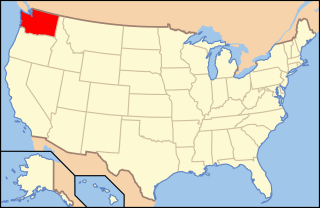
The following outline is provided as an overview of and topical guide to infrastructure of the U.S. state of Washington.