
A levee, dike, dyke, embankment, floodbank, or stop bank is a structure that is usually earthen and that often runs parallel to the course of a river in its floodplain or along low-lying coastlines. The purpose of a levee is to keep the course of rivers from changing and to protect against flooding of the area adjoining the river or coast. Levees can be naturally occurring ridge structures that form next to the bank of a river, or be an artificially constructed fill or wall that regulates water levels. Ancient civilizations in the Indus Valley, ancient Egypt, Mesopotamia and China all built levees. Today, levees can be found around the world, and failures of levees due to erosion or other causes can be major disasters.

A flood is an overflow of water that submerges land that is usually dry. In the sense of "flowing water", the word may also be applied to the inflow of the tide. Floods are an area of study of the discipline hydrology and are of significant concern in agriculture, civil engineering and public health. Human changes to the environment often increase the intensity and frequency of flooding, for example land use changes such as deforestation and removal of wetlands, changes in waterway course or flood controls such as with levees, and larger environmental issues such as climate change and sea level rise. In particular climate change's increased rainfall and extreme weather events increases the severity of other causes for flooding, resulting in more intense floods and increased flood risk.
The Season of the Inundation or Flood was the first season of the lunar and civil Egyptian calendars. It fell after the intercalary month of Days over the Year and before the Season of the Emergence.
The Season of the Emergence was the second season of the lunar and civil Egyptian calendars. It fell after the Season of the Inundation and before the Season of the Harvest.
The Season of the Harvest or Low Water was the third and final season of the lunar and civil Egyptian calendars. It fell after the Season of the Emergence and before the spiritually dangerous intercalary month, after which the New Year's festivities began the Season of the Inundation (Ꜣḫt).

A nilometer was a structure for measuring the Nile River's clarity and water level during the annual flood season. There were three main types of nilometers, calibrated in Egyptian cubits: (1) a vertical column, (2) a corridor stairway of steps leading down to the Nile, or (3) a deep well with culvert. If the water level was low, the fertility of the floodplain would suffer. If it was too high, the flooding would be destructive. There was a specific mark that indicated how high the flood should be if the fields were to get good soil.
Thout, also known as Thoth and Tut, is the first month of the ancient Egyptian and Coptic calendars. It lies between 11 September and 10 October of the Gregorian calendar. The month of Thout is also the first month of the Season of Akhet (Inundation) in Ancient Egypt, when the Nile floods historically covered the land of Egypt; it has not done so since the construction of the High Dam at Aswan.
Paopi, also known as Phaophi and Babah, is the second month of the ancient Egyptian and Coptic calendars. It lasts between 11 October and 9 November of the Gregorian calendar, unless the previous Coptic year was a leap year. The month of Paopi is the second month of the Season of Akhet (Inundation) in Ancient Egypt, when the Nile floods inundated the land.
Hathor, also known as Athyr and Hatur, is the third month of the ancient Egyptian and Coptic calendars. It lies between November 10 and December 9 of the Gregorian calendar. The month of Hathor is also the third month of the season of Akhet (Inundation) in Ancient Egypt, when the Nile floods historically covered the land of Egypt; they have not done so since the construction of the High Dam at Aswan.

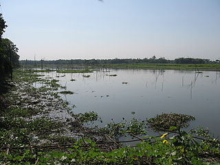
The Inner Niger Delta, also known as the Macina or Masina, is the inland delta of the Niger River. It is an area of fluvial wetlands, lakes and floodplains in the semi-arid Sahel area of central Mali, just south of the Sahara desert.

River engineering is a discipline of civil engineering which studies human intervention in the course, characteristics, or flow of a river with the intention of producing some defined benefit. People have intervened in the natural course and behaviour of rivers since before recorded history—to manage the water resources, to protect against flooding, or to make passage along or across rivers easier. Since the Yuan Dynasty and Ancient Roman times, rivers have been used as a source of hydropower. From the late 20th century, river engineering has had environmental concerns broader than immediate human benefit and some river engineering projects have been concerned exclusively with the restoration or protection of natural characteristics and habitats.
A beel is a billabong or a lake-like wetland with static water (as opposed to moving water in rivers and canals - typically called khaals in Bengali, in the Ganges - Brahmaputra flood plains of the Eastern Indian states of West Bengal, and Assam and in the country of Bangladesh. The term owes its origins to the word of the same pronunciation meaning "pond" and "lake" in the Bengali and Assamese languages.

Sekhemre Seusertawy Sobekhotep VIII was possibly the third king of the 16th Dynasty of Egypt reigning over the Theban region in Upper Egypt during the Second Intermediate Period. Alternatively, he may be a ruler of the 13th or 17th Dynasty. If he was a king of the 16th Dynasty, Sobekhotep VIII would be credited 16 years of reign by the Turin canon, starting c. 1650 BC, at the time of the Hyksos invasion of Egypt.
Flood stage is the water level or stage at which the surface of a body of water has risen to a sufficient level to cause sufficient inundation of areas that are not normally covered by water, causing an inconvenience or a threat to life and property. When a body of water rises to this level, it is considered a flood event. Flood stage does not apply to areal flooding. As areal flooding occurs, by definition, over areas not normally covered by water, the presence of any water at all constitutes a flood. Usually, moderate and major stages are not defined for areal floodplains.
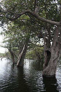
Igapó is a word used in Brazil for blackwater-flooded forests in the Amazon biome. These forests and similar swamp forests are seasonally inundated with freshwater. They typically occur along the lower reaches of rivers and around freshwater lakes. Freshwater swamp forests are found in a range of climate zones, from boreal through temperate and subtropical to tropical. In the Amazon Basin of Brazil, a seasonally whitewater-flooded forest is known as a várzea, which is similar to igapó in many regards; the key difference between the two habitats is in the type of water that floods the forest.

The Landport is a gate into the territory of Gibraltar. It was originally the only entrance to the fortification from the land and so was heavily fortified and guarded.

The Inundation was a flooded and fortified area of ground on the sandy isthmus between Spain and Gibraltar, created by the British in the 18th century to restrict access to the territory as part of the fortifications of Gibraltar. It was originally a marshy area known as the Morass at the far south-western end of the isthmus, occupying the area adjacent to the north-western flank of the Rock of Gibraltar. The Morass was dug out and expanded to create an artificial lake which was further obstructed by iron and wooden obstacles in the water. Two small fortifications on either side controlled access to Gibraltar. The only road to and from the town ran along a narrow causeway between the Inundation and the sea which was enfiladed by batteries mounted on the lower slopes of the Rock. The Inundation existed for about 200 years before it was infilled and built over after the Second World War.

The Queen's Lines are a set of fortified lines, part of the fortifications of Gibraltar, situated on the lower slopes of the north-west face of the Rock of Gibraltar. They occupy a natural ledge which overlooks the landward entrance to Gibraltar and were an extension to the north-east of the King's Lines. They run from a natural fault called the Orillon to a cliff above the modern Laguna Estate, which stands on the site of the Inundation, an artificial lake created to obstruct landward access to Gibraltar. The Prince's Lines run immediately behind and above them on a higher ledge. All three of the Lines were constructed to enfilade attackers approaching Gibraltar's Landport Front from the landward direction.
The Prince's Lines are part of the fortifications of Gibraltar, situated on the lower slopes of the north-west face of the Rock of Gibraltar. They are located at a height of about 70 feet (21 m) on a natural ledge above the Queen's Lines, overlooking the landward entrance to Gibraltar, and run from a natural fault called the Orillon to a cliff at the southern end of the isthmus linking Gibraltar with Spain. The lines face out across the modern Laguna Estate, which stands on the site of the Inundation, an artificial lake created to obstruct landward access to Gibraltar. They were constructed to enfilade attackers approaching Gibraltar's Landport Front from the landward direction.