Inverchaolain Church

Last updated

Inverchaolain Church
Inverchaolain Parish Church
Inverchaolain Kirk (geograph 3263385).jpg
The church in 2012, its centenary year, looking north
Inverchaolain Church
55°55′59″N5°03′28″W / 55.932994°N 5.0577448°W / 55.932994; -5.0577448
LocationGlenstriven Road, Inverchaolain, Argyll and Bute
CountryScotland, United Kingdom
Denomination Church of Scotland
History
Statusclosed
Architecture
Functional statusdisused
Years built1912(112 years ago) (1912)
Closed1990(34 years ago) (1990)

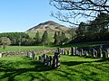
Inverchaolain Church is a former Church of Scotland church building in Inverchaolain, Cowal, Argyll and Bute, Scotland. [1] Located on the eastern shores of Loch Striven, just north of Inverchaolain Burn, the church was built in 1912. [1] It is the fourth church on the site. There is a possibility that the second church, rumoured to be dedicated to Saint Bridget, was located about 200 metres (660 ft) northeast of the present structure. [1]

Contents

When the foundations of the previous church were dug in 1812, several dozen human skulls were uncovered, as well as a few bones of very large size. [1] Argyll and Bute Council have listed a claymore stone, an ancient tombstone with a Gaelic inscription and a coping stone from the pre-Reformation church, as being in an around the property. [1]

The church closed in 1990. [1]

Graveyard

The graveyard contains burials and headstones from previous incarnations of the church. There were around 230 gravestones as of 2014, the earliest dating to 1732. [2]

Related Research Articles

<span class="mw-page-title-main">Argyll and Bute</span> Council area of Scotland

Argyll and Bute is one of 32 unitary council areas in Scotland and a lieutenancy area. The current lord-lieutenant for Argyll and Bute is Jane Margaret MacLeod. The administrative centre for the council area is in Lochgilphead at Kilmory Castle, a 19th-century Gothic Revival building and estate. The current council leader is Councillor Jim Lynch.

<span class="mw-page-title-main">Dunoon</span> Town in Scotland

Dunoon is the main town on the Cowal peninsula in the south of Argyll and Bute, Scotland. It is located on the western shore of the upper Firth of Clyde, to the south of the Holy Loch and to the north of Innellan. As well as forming part of the council area of Argyll and Bute, Dunoon also has its own community council. Dunoon was a burgh until 1976.

<span class="mw-page-title-main">Argyll</span> Historic county in Scotland

Argyll, sometimes called Argyllshire, is a historic county and registration county of western Scotland.

<span class="mw-page-title-main">Cowal</span> Human settlement in Scotland

Cowal is a rugged peninsula in Argyll and Bute, on the west coast of Scotland. It is bounded on the west by Loch Fyne and on the east by Loch Long and the Firth of Clyde. The Kyles of Bute separate it from Bute to the south.

<span class="mw-page-title-main">Royal Commission on the Ancient and Historical Monuments of Scotland</span> 1908–2015 Scottish government agency

The Royal Commission on the Ancient and Historical Monuments of Scotland (RCAHMS) was an executive non-departmental public body of the Scottish Government that was "sponsored" [financed and with oversight] through Historic Scotland, an executive agency of the Scottish Government.

<span class="mw-page-title-main">Seafield Tower</span> Architectural structure in Fife, Scotland, UK

Seafield Tower is a ruined castle on the North Sea coast of Fife in Scotland. The monument is also referred to as a 'Medieval Tower House'.

<span class="mw-page-title-main">Ardchattan Priory</span>

The Ardchattan Priory was a Valliscaulian monastic community in Ardchattan, Argyll, Scotland.

Ian Gordon Lindsay was a Scottish architect. He was most noted for his numerous restoration projects, sometimes of whole villages but curiously was also involved in the design of several hydro-electric power stations.

<span class="mw-page-title-main">Finlaggan</span>

Finlaggan is a historic site on Eilean Mòr in Loch Finlaggan. The Loch, the island, and Finlaggan Castle lie on Islay, around two kilometres to the northwest of Ballygrant.

<span class="mw-page-title-main">Oban</span> Coastal town in Scotland

Oban is a resort town within the Argyll and Bute council area of Scotland. Despite its small size, it is the largest town between Helensburgh and Fort William. During the tourist season, the town can have a temporary population of up to over 24,000 people. Oban occupies a setting in the Firth of Lorn. The bay forms a near perfect horseshoe, protected by the island of Kerrera; and beyond Kerrera, the Isle of Mull. To the north, is the long low island of Lismore and the mountains of Morvern and Ardgour.

Auchenbreck Castle is located in Argyll and Bute, Scotland. Its remains are situated in Kilmodan parish, near the south of Glendaruel, 9 kilometres (5.6 mi) north of Tighnabruaich on the Cowal peninsula. Little remains of the castle, other than a flat rectangular platform, around 35 by 18 metres, between Auchenbreck farmhouse and the Auchenbreck Burn. This is partially bounded by a revetment wall up to 2.2 metres high.

An Caisteal is a hill fort located on the island of Coll. This island is one of the islands which make up the Inner Hebrides located on the west coast of Scotland. The fort is located at grid reference NM17185815. Located 1,200 yards (1.1 km) to the north-east of An Caisteal is Dùn Foulag. Dùn Foulag, located at grid reference NM17505908, was once thought to be a dun, though it is now considered to be only a naturally rocky knoll.

<span class="mw-page-title-main">Kilmun Parish Church and Argyll Mausoleum</span> Church in Scotland

Kilmun Parish Church and Argyll Mausoleum in Kilmun, Argyll and Bute, Scotland, consists of St Munn's Church, as well as the adjacent mausoleum of the Dukes of Argyll and a historically significant churchyard. The complex is located on the summit of a slight knoll about ten metres from the shoreline of the Holy Loch on the Cowal Peninsula in Argyll, Scotland. The existing church dates from 1841 and occupies the site of an older, medieval church. A partly ruined tower from the medieval period still stands to the west of the present building.

<span class="mw-page-title-main">Asgog Loch</span> A lake in Argyll and Bute, Scotland

Asgog Loch is a natural freshwater loch in Argyll and Bute, Scotland. It is located about 4 kilometres (2.5 mi) southwest of Tighnabruaich, on the Cowal peninsula. The loch was dammed during the 19th century to create an impounding reservoir for the supply of freshwater to the Low Mills of the nearby gunpowder mills at Millhouse.

<span class="mw-page-title-main">Inverchaolain</span> Human settlement in Scotland

Inverchaolain is a hamlet on the Cowal peninsula, Argyll and Bute, Scotland. It lies on the east shore of Loch Striven, to the south of Glenstriven and to the north of Knockdow.

<span class="mw-page-title-main">Rosneath Peninsula</span> Peninsula in Argyll and Bute, Scotland

Rosneath Peninsula is a peninsula in Argyll and Bute, western Scotland, formerly in the historic county of Dunbartonshire. The peninsula is formed by the Gare Loch in the east, and Loch Long in the west, both merge with the upper Firth of Clyde.

<span class="mw-page-title-main">Dunearn</span>

Dunearn is a hill fort located 15 kilometres (9.3 mi) south south east of Nairn in Highland, Scotland. It is situated on a steep-sided hill called Doune rising to approximately 266 metres (873 ft) above ordnance datum just south of Dulsie Bridge in the parish of Ardclach.

Punds Water is a freshwater loch near Mangaster in Northmavine, Shetland. It also gives its name to a nearby Neolithic heel-shaped cairn.

<span class="mw-page-title-main">Gadgirth Old Ha'</span>

The castle known as Gadgirth Old Ha' or Gadgirth Old Hall, was the first castle at Gadgirth, held by the Chalmer family, standing on a whinstone promontory overlooking the River Ayr in the Parish of Coylton, the old district of Kyle, now part of South Ayrshire, Scotland.

References

Bibliography