Related Research Articles
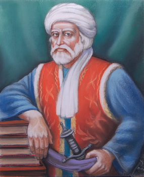
Khošāl Khān Khaṭak the renowned King of Kings(Pashto: خوشال خان خټک; Urdu, Persian: خوشحال خان خٹک; 1613 – 20 February 1689), also known as Khushal Baba, was a 17th-century Pashtun poet, chief, and warrior. Khushal Khan served the Mughal Empire protecting them from Pashtun warriors over most of his lifespan. After being expelled from his tribal chiefdom and replaced with his son by his Mughal superiors, Khushal Khan turned against the Mughals. Afterwards, Khushal preached the union of all Pashtuns, and encouraged revolt against the Mughal Empire, promoting Pashtun nationalism in the last years of his life through poetry. Much of Khushal's poetry is in Pashto but some is also in Persian. Khushal is considered the "father of Pashto literature" and the national poet of Afghanistan.

Nowshera District is a district in the Peshawar Division of the Khyber Pakhtunkhwa province of Pakistan. The capital and district headquarter is Nowshera city.
Cherat is a hill station dating from the 1860s that is located immediately above the villages of Chapri,Bakhti, Saleh Khana, Kotli Kalan and Dak Ismail Khel in the Nowshera District of Khyber-Pakhtunkhwa in Pakistan. Cherat lies 34 miles south east from the city of Peshawar at an elevation of 4,500 feet on the west of the Khattak range, which divides the district of Nowshera from Kohat District.

Nowshera is the capital city of Nowshera District in the Khyber Pakhtunkhwa province of Pakistan. It is the 78th largest city in Pakistan and ninth largest city in the province of Khyber Pakhtunkhwa.

Ajmal Khan Khattak was a Pakistani politician, writer and Pashto language poet from North-West Frontier Province, who served as the President of Awami National Party. He was a close friend of Khan Abdul Wali Khan.
Pirpiai is a town in the District of Nowshera in Khyber-Pakhtunkhwa, Pakistan. Its population is around 35,000. Pirpiai has a high literacy rate of 92%, compared with Pakistan's average literacy rate of 55%. The village is on GT Road, 8 km from Nowshera Cantonment towards Peshawar. Most of the villagers are working-folk, adding to the work-pool through government service, and self-employment. Substantial number of people from the village are working abroad and adding to national exchequer. The village is rich in producing educated and professional class like engineers, doctors, officers of armed forces, civil servants, professors and so on.

Badrashi is a town in the Nowshera District in Khyber Pakhtunkhwa. It is located at 33°59′19″N72°1′30″E.
Khaglan Wala (ڪھگلانواله) is a village and union council of Isakhel Tehsil of Mianwali District in the Punjab province of Pakistan. It is part of Isa Khel Tehsil and is located at 32°37'60N 71°16'0E. Located on the northern bank of Kurram River. It is one of the villages situated on the western borders of Punjab province adjacent to KPK province. Its population is about 3000 people. This is comparatively a developed village. Basic facilities like electricity, telephone, metalled road, internet, schools, water supply system and sewerage system are provided to the inhabitants of this village. It is also a well-planned village situated on a 40 feet wide metalled road. A 30' wide main street runs east to west through the village, equally dividing the entire village into two parts. Three other streets run north to south crossing the main street at 90°. There are four mosques i.e Grand Mosque, Masjid Naurang Khel, Masjid Khizar Khel in Mohalla Khizar Khel and Masjid Abadi Tajpora in this settlement. The scene of river Kurram alongside bela jungle provides beautiful look to this historical village. Khaglanwala is hub of different routes coming from various villages situated on other side of the River Kurram, to reach Isa Khel city.
Akora Khattak or Sarai Akora is a town in the Jehangira tehsil of the Nowshera District in the Khyber Pakhtunkhwa province of Pakistan. Its location is adjacent to the Kabul River, which converges with the Indus River about 15 kilometres downstream. Neighbouring places are Nowshera Cantonment to the west and Jahangira town to the east.
Sherani or Shirani is a rural district in the Zhob division of Balochistan province of Pakistan. The district lies within the Sulaiman mountain range, and its highest point is the Takht-e-Sulaiman.
Jehangira is a town in the Khyber-Pakhtunkhwa province of Pakistan.
Saleh Khana is a large village in the Nowshera District of Khyber Pakhtunkhwa, Pakistan located just below the Cherat mountains.
Petaw Payan, is a developing village in the Nowshera District of Khyber Pakhtunkhwa province of Pakistan. It is one of the main link for connecting the far Southwestern villages to the town of Jehangira. It is situated at 33"56'03.91" N and 72"10'39.84" E and 340 meters high from the sea level.
The Akakhel, pronounced Akaa Khel or Akakhail, are a Pashtun sub-tribe of the Ghilji/Ghilzais confederation. Their mother language is Pashto. In the early 20th century, the tribe was generally pastoral. The Akakhel are one of the largest Ghilji Pashtun subtribes. A reasonable majority of those who were living on the Durand Line migrated since 1800s into Khyber Pakhtunkhwa, Balochistan and Punjab provinces of Pakistan to Sikander Abad Charsadda, Peshawar, Swat(Barikot), Buner(Topdara), Abbottabad, Nowshera, Mardan, Attock, Rawalpindi, Islamabad, Gujranwala, Gojra, Faisalabad, Lahore, Multan, Hyderabad, Karachi and Quetta. The exact population number of this clan is not known; however, it is estimated to be around 2 million all around the world The population of this tribe primarily lives in Pakistan and Afghanistan. 85% live in Pakistan and about 1% or 2% live in Afghanistan and remaining 13% lives in England, Germany, United Arab Emirates, China, Malaysia, Canada and United States of America.
Siavi is a village in Hend Khaleh Rural District, Tulem District, Sowme'eh Sara County, Gilan Province, Iran. This is a small region of one of the earliest ethnic Pashtuns in Iran, thought to have originated from Southern Afghanistan hundreds of years ago but have been able to keep their linguistic and cultural identity intact. Also, there is a village in KPK province of Pakistan, in Nizampur region of Nowhshera District by the same name, where many of the members of Siavi clan from Iran have permanently settled dating back to multiple generations.

Manglawar is an administrative unit, known as Union council of Tehsil Babuzai, of Swat District in the Khyber Pakhtunkhwa province of Pakistan and former capital of Kingdom of Swat. It is located at 34°48'30.7"N 72°25'50.0"E with an average altitude of 987 meters.
Lachi is one of the two tehsils in the Kohat District of Khyber Pakhtunkhwa province in Pakistan, located south of the district capital Kohat. It houses about 100,000 inhabitants, living in 1,161 square kilometres (448 sq mi). The tehsil is subdivided into nine union councils. About 40% of the working population is employed outside the tehsil.It is a rural area where most households' livelihood depends on remittances and subsistence farming. Education is provided through several private and government high schools, as well as a government degree college affiliated with Kohat University.
Kahi is a village in the Nowshera district, in Khyber Pakhtunkhwa, Pakistan.
Adamzai is a village in Nowshera District, Khyber Pakhtunkhwa province, Pakistan, located between Akora Khattak and Shaidu. Khan's living here belong to the khushal khan khattak lineage of the khattak tribe. The tomb of Great Afghan Warrior and pashto poet Khushal Khan Khattak is situated in the outskirts of adamzai.
Jabba Khattak is a village located in Pabbi Tehsil of Nowshera District, Pakistan. It has a small dam which is being built for irrigation and to supply drinking water to the area surrounding the village.
References
34°13′30″N71°44′0″E / 34.22500°N 71.73333°E [1]
- ↑ Garren, William R., and Page, Carl R. Gazetteer of Pakistan: Names Approved by the United States Board on Geographic Names . United States, Defense Mapping Agency, 1983. 259.