
The Arctic Archipelago, also known as the Canadian Arctic Archipelago, is a group of islands north of the Canadian mainland.

Kings County is located in eastern Prince Edward Island, Canada.

Montague-Kilmuir is a provincial electoral district for the Legislative Assembly of Prince Edward Island, Canada.

Lot 36 is a township in Queens County, Prince Edward Island, Canada. It is part of Bedford Parish. Lot 36 was awarded to merchants George Spence and John Mill in the 1767 land lottery. It was sold to Donald MacDonald in 1775.

Brudenell River Provincial Park is a provincial park in Prince Edward Island, Canada. It lies on the north side of the Brudenell River, and some of its land is also used by Rodd Brudenell Resort. Brudenell River is the largest provincial park in eastern Prince Edward Island. It has two 18-hole golf courses, Brudenell River Golf Course and Dundarave Golf Course.
Panmure Island Provincial Park is a provincial park in Prince Edward Island, Canada. It is located along a causeway connecting Prince Edward Island with Panmure Island.
Belmont Provincial Park is a provincial park in Prince Edward Island, Canada.
Pinette Park Provincial Park is a provincial park in Prince Edward Island, Canada.

Murray Harbour is a municipality that holds rural municipality status in Prince Edward Island, Canada. It is located in southeastern Kings County.
Belfast is a municipality that holds community status in Prince Edward Island, Canada. It is located in southeastern Queens County in the townships of Lot 57 and Lot 58.
Morell is a municipality that holds community status in Prince Edward Island, Canada. It is located in Kings County east of Bristol.
Murray River is a municipality that holds community status in Prince Edward Island, Canada. It is located in Kings County.

Georgetown-St. Peters is a provincial electoral district for the Legislative Assembly of Prince Edward Island, Canada. It was created from mostly 3rd Kings and part of 5th Kings. The district was named Georgetown-Baldwin's Road from 1996 to 2007.
Cardigan, Prince Edward Island was a municipality that held community status in Prince Edward Island, Canada. It was a fishing community in eastern Kings County. The community was named after James Brudenell, 5th Earl of Cardigan, later Duke of Montague. Situated on the Cardigan River and originally named Cardigan Bridge, the community started and grew as a result of the shipbuilding industry and lumber trade.
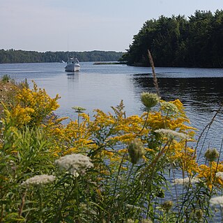
The Three Rivers are the three tidal estuaries in eastern Prince Edward Island, Canada. The water bodies are the Brudenell, Cardigan and Montague rivers, which in 2004 were included on the list of outstanding Canadian Heritage Rivers. The rivers are navigable by canoe for 52 kilometres (32 mi).
Central Kings is a municipality that holds community status in Prince Edward Island, Canada.
Hazelbrook is a municipality that holds community status in Prince Edward Island, Canada.
Kinross is a settlement in Prince Edward Island. It is named after Kinross in Scotland. It is within the census subdivision of Lot 57, Prince Edward Island. Kinross borders three other communities: Uigg, Orwell, and Lyndale.

Mount Buchanan is a small town in Prince Edward Island, Canada. Located southeast of Charlottetown, it is part of the Community of Belfast.
Three Rivers is a town within Kings County in Prince Edward Island that was incorporated on September 28, 2018 through an amalgamation of seven municipalities and adjacent unincorporated areas. The municipalities that were amalgamated included two towns – Georgetown and Montague – and five rural municipalities – Brudenell, Cardigan, Lorne Valley, Lower Montague, and Valleyfield.

