
The Waimakariri River is one of the largest rivers in Canterbury, on the eastern coast of New Zealand's South Island. It flows for 151 kilometres (94 mi) in a generally southeastward direction from the Southern Alps across the Canterbury Plains to the Pacific Ocean.

The Lewis River is a river in the Canterbury region of New Zealand. The valley of this river forms the southeastern approach to Lewis Pass; the river is thus adjacent to State Highway 7. The Lewis River is a tributary of the Boyle River. The Nina River flows into the Lewis River a few kilometres upstream from the confluence with the Boyle River. Land Information New Zealand lists the name of the river as "not official", i.e. the name is not confirmed by the New Zealand Geographic Board. It was named for the surveyor Henry Lewis, who discovered the pass in 1860 alongside his colleague Christopher Maling. Later in 1860, the river was named by Julius von Haast during his own expedition; von Haast became the brother-in-law of Lewis' daughter in 1866.

The Selwyn River flows through the Selwyn District of Canterbury in the South Island of New Zealand.

The Nimrod Glacier is a major glacier about 85 nautical miles long, flowing from the polar plateau in a northerly direction through the Transantarctic Mountains into the Ross Ice Shelf, Antarctica.
The Commonwealth Range is a north-south trending range of rugged mountains, 60 nautical miles long, located within the Queen Maud Mountains on the Dufek Coast of the continent of Antarctica. The range borders the eastern side of Beardmore Glacier from Keltie Glacier to the Ross Ice Shelf. The range is southeast of the Queen Alexandra Range, which is to the west of the Beardmore Glacier. It is west of the Hughes Range and north of the Supporters Range and the Barton Mountains.
The Edison River is a river of the Westland District of New Zealand. It arises in the Solution Range near Mount Elliot and flows north-west and north into the Mahitahi River.
The Garry River is a river in the Canterbury region of New Zealand. It arises in the Mount Thomas Forest near Mount Thomas and flows south-east into Ashley River / Rakahuri. Blowhard Stream is a tributary.

The Glentui River is a river in the Canterbury region of New Zealand. It arises on the slopes of Mount Richardson and flows south-east through the locality of Glentui and into Ashley River / Rakahuri, which exits in the Pacific Ocean. The river was earlier called Tui Creek, and the locality named from the station Glentui established by H.C.H. Knowles in 1854.
The Hawkins River is a river in New Zealand. A major tributary of Canterbury's Selwyn River, it flows generally southeast from its source to the southwest of Springfield, reaching the Selwyn 10 kilometres (6 mi) west of Burnham.
The Hororata River is a river of Canterbury, in the South Island of New Zealand. A tributary of the Selwyn River, the Hororata has its sources in rough hill country north of Windwhistle, and flows east through the township of Hororata before reaching the Selwyn 12 kilometres (7 mi) northwest of Dunsandel.
The Karetu River is a river of New Zealand's eastern South Island. It flows south from the slopes of Mount Karetu before its outflow into the Okuku River at the edge of the Canterbury Plains 40 kilometres (25 mi) northwest of Christchurch.

The L II River is a small spring-fed river in Canterbury, New Zealand, technically a canal which was dug by European colonists to connect springs and drain land. It rises near Lincoln and flows through very flat farmland, mostly fed by land drainage ditches before emptying into Lake Ellesmere / Te Waihora just east of the mouth of the Selwyn River / Waikirikiri.
The Lambert River is a river of the West Coast Region of New Zealand's South Island. It flows north from the Lambert Glacier in the Southern Alps, joining with the Wanganui River 15 kilometres (9 mi) southeast of Harihari.
The Lilburne River is a river of northern Canterbury, New Zealand. Formerly known as the Lillburn River, its spelling was corrected in 2003. It rises in the Puketeraki Range, flowing south then east to join Ashley River / Rakahuri.
The Makerikeri River is a river of the north Canterbury region of New Zealand's South Island. It flows south from its headwaters 15 kilometres (9 mi) west of Amberley, reaching the Ashley River / Rakahuri close to Rangiora.

The Nina River is a river of the north Canterbury region of New Zealand's South Island. It flows predominantly east from its source within Lake Sumner Forest Park, veering southeast shortly before it flows into the Lewis River 35 kilometres (22 mi) west of Hanmer Springs.

The Okuku River is a river of the north Canterbury region of New Zealand's South Island. It flows predominantly south from several sources in and close to the eastern edge of the Puketeraki Range west of Waikari, flowing through a steep gorge in the Okuku Range before flowing into the Ashley River / Rakahuri 20 kilometres (12 mi) east of Oxford.
The Whistler River is a river of the Canterbury region of New Zealand's South Island. It flows generally southeast from the Puketeraki Range to reach the Ashley River / Rakahuri 15 kilometres (9 mi) north of Oxford.
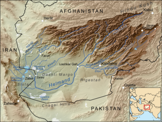
The Dori, also called the Lora and Kadanai, is a river of Afghanistan and Pakistan. It runs for 320 kilometres (200 mi) from Balochistan province in Pakistan through Kandahar Province in Afghanistan, then flows into the Arghandab River.
The Taipo River is a river of the central West Coast Region of New Zealand's South Island. It flows north from its sources west of Mount Rolleston, fed by the waters of several mountain streams. After some 15 kilometres it turns northeast to flow past the Bald Range before reaching the valley of the Taramakau River into which it flows 35 kilometres east of Hokitika.
