Hawaii is the largest island in the United States, located in the state of Hawaii. It is the southeasternmost of the Hawaiian Islands, a chain of volcanic islands in the North Pacific Ocean. With an area of 4,028 square miles (10,430 km2), it has 63% of the Hawaiian archipelago's combined landmass. However, it has only 13% of the archipelago's population. The island of Hawaiʻi is the third largest island in Polynesia, behind the north and south islands of New Zealand.

Pāhoa is a census-designated place (CDP) in the District of Puna in Hawai‘i County, Hawai‘i, United States. The population was 924 at the 2020 census. The population dropped by 1.8% from 945 in the 2010 census.

Black sand is sand that is black in color. One type of black sand is a heavy, glossy, partly magnetic mixture of usually fine sands containing minerals such as magnetite, found as part of a placer deposit. Another type of black sand, found on beaches near a volcano, consists of tiny fragments of basalt.

Kīlauea is an active shield volcano in the Hawaiian Islands. Located along the southeastern shore of Hawai'i Island, the volcano is between 210,000 and 280,000 years old and emerged above sea level about 100,000 years ago. Historically, it is the most active of the five volcanoes that together form the island of Hawaii. Kīlauea is also one of the most active volcanoes on Earth, with the most recent eruption from June 7-19, 2023 after a series of earthquakes, when multiple vents erupted lava within Halemaʻumaʻu, a pit crater in the volcano's summit caldera, and building a fissure cinder cone approximately 40 m (130 ft) high. Halema'uma'u has been the sole eruptive area of Kīlauea since December 2020 with intermittent lava effusion from then to March 7, 2023, followed by a 90 day pause.

Hualālai is an active volcano on the island of Hawaiʻi in the Hawaiian Islands. It is the westernmost, third-youngest and the third-most active of the five volcanoes that form the island of Hawaiʻi, following Kīlauea and the much larger Mauna Loa. Its peak stands 8,271 feet (2,521 m) above sea level. Hualālai is estimated to have risen above sea level about 300,000 years ago. Despite maintaining a very low level of activity since its last eruption in 1801, and being unusually inactive for the last 2,000 years, Hualālai is still considered active, and is expected to erupt again sometime in the next 100 years. The relative unpreparedness of the residents in the area caused by the lull in activity would worsen an eruption's consequences.

Hawaiʻi Volcanoes National Park is an American national park located in the U.S. state of Hawaii on the island of Hawaii. The park encompasses two active volcanoes: Kīlauea, one of the world's most active volcanoes, and Mauna Loa, the world's largest shield volcano. The park provides scientists with insight into the development of the Hawaiian Islands and access for studies of volcanism. For visitors, the park offers dramatic volcanic landscapes, glimpses of rare flora and fauna, and a view into the traditional Hawaiian culture connected to these landscapes.
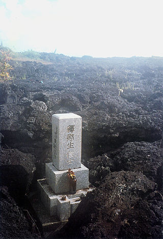
Kaimū was a small town in the Puna District on Island of Hawaiʻi that was completely destroyed by an eruptive flow of lava from the Kūpaʻianahā vent of the Kīlauea volcano in 1990. In Hawaiian, kai mū means "gathering [at the] sea" as to watch surfing. The lava flow that destroyed Kaimū and nearby Kalapana erupted from the southeast rift zone of Kīlauea.

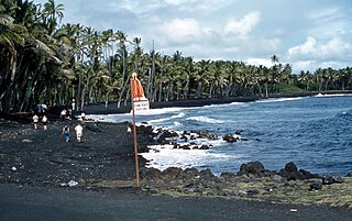
Punaluʻu Beach is a beach between Pāhala and Nāʻālehu on the Big Island of the U.S. state of Hawaii. The beach has black sand made of basalt and created by lava flowing into the ocean which explodes as it reaches the ocean and cools. This volcanic activity is in the Hawaiʻi Volcanoes National Park. Punaluʻu is frequented by endangered hawksbill and green turtles, which can often be seen basking on the black sand.
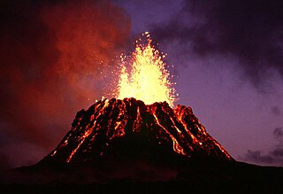
Puʻu ʻŌʻō is a volcanic cone on the eastern rift zone of Kīlauea volcano in the Hawaiian Islands. The eruption that created Puʻu ʻŌʻō began on January 3, 1983, and continued nearly continuously until April 30, 2018, making it the longest-lived rift-zone eruption of the last two centuries.


A Hawaiian eruption is a type of volcanic eruption where lava flows from the vent in a relatively gentle, low level eruption; it is so named because it is characteristic of Hawaiian volcanoes. Typically they are effusive eruptions, with basaltic magmas of low viscosity, low content of gases, and high temperature at the vent. Very small amounts of volcanic ash are produced. This type of eruption occurs most often at hotspot volcanoes such as Kīlauea on Hawaii's big island and in Iceland, though it can occur near subduction zones and rift zones. Hawaiian eruptions may occur along fissure vents, such as during the eruption of Mauna Loa in 1950, or at a central vent, such as during the 1959 eruption in Kīlauea Iki Crater, which created a lava fountain 580 meters (1,900 ft) high and formed a 38-meter cone named Puʻu Puaʻi. In fissure-type eruptions, lava spurts from a fissure on the volcano's rift zone and feeds lava streams that flow downslope. In central-vent eruptions, a fountain of lava can spurt to a height of 300 meters or more.

Papakōlea Beach is a green sand beach located near South Point, in the Kaʻū district of the island of Hawaiʻi. It is one of only four green sand beaches in the world, the others being Talofofo Beach, Guam; Punta Cormorant on Floreana Island in the Galapagos Islands; and Hornindalsvatnet, Norway. It gets its distinctive coloring from olivine sand eroded out of the enclosing volcanic cone.

Kalani Oceanside Retreat, also known as Kalani Honua or Kalani, is a non-profit retreat center located on the Big Island of Hawai'i. It was established in 1975 and focuses on natural and holistic living, yoga and relaxation, and spiritual retreats. Kalani has historically been staffed by a core group of administrators, managers, and coordinators, plus volunteers from around the world.

The 2018 lower Puna eruption was a volcanic event on the island of Hawaiʻi, on Kīlauea volcano's East Rift Zone that began on May 3, 2018. It is related to the larger eruption of Kīlauea that began on January 3, 1983, though some volcanologists and USGS scientists have discussed whether to classify it as a new eruption. Outbreaks of lava fountains up to 300 feet (90 m) high, lava flows, and volcanic gas in the Leilani Estates subdivision were preceded by earthquakes and ground deformation that created cracks in the roads.

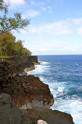
Route 137 is a state highway in Hawaii County, Hawaii. The highway, known as the Kapoho-Kalapana Road, the Beach Road, or the Red Road, travels along the eastern coast of the island of Hawaii between Kalapana and Kapoho. It passes near Kīlauea and its lava fields, as well as Isaac Hale Beach Park and other protected areas.
The MacKenzie State Recreation Area is a park in southern Puna, on Hawaiʻi Island in the US state of Hawaii.

The Puna Geothermal Venture (PGV) is a geothermal energy power plant on the island of Hawaii, the largest island in the state of Hawaii. The plant was shut down shortly after the start of the May 2018 lower Puna eruption, and resumed power generation in November 2020. The eruption had caused lava to flow over a PGV power substation, a warehouse and at least three geothermal wells that had been preventatively quenched and capped when lava fountains erupted nearby, eventually also cutting off road access.
Arthur Johnsen was an American artist. Born and raised on Oahu and living most of his post-university life on the Big Island of Hawaii, he is known for his impressionistic paintings and murals of Hawaiiana.