External links
| This article about a Mexican airport is a stub. You can help Wikipedia by expanding it. |
Isla San Marcos Airstrip | |||||||||||
|---|---|---|---|---|---|---|---|---|---|---|---|
| Summary | |||||||||||
| Airport type | Private | ||||||||||
| Operator | Compañía Occidental Mexicana SA de CV | ||||||||||
| Serves | San Marcos | ||||||||||
| Location | Mulegé Municipality, Baja California Sur state, Mexicor | ||||||||||
| Elevation AMSL | 134 ft / 41 m | ||||||||||
| Coordinates | 27°11′15″N112°04′12″W / 27.18750°N 112.07000°W Coordinates: 27°11′15″N112°04′12″W / 27.18750°N 112.07000°W | ||||||||||
| Runways | |||||||||||
| |||||||||||
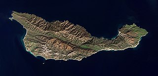
Isla San Marcos Airstrip( IATA : N/A) is a private-use dirt airstrip located on the South coast of Isla San Marcos, Baja California Sur, Mexico, an island located in the Gulf of California.
It is located 10 miles southeast of Santa Rosalía, Municipality of Mulegé.
The airstrip is handled by "Compañía Occidental Mexicana S.A de C.V.", a mining company that exploits the gypsum deposits that exist on the island.
The airstrip handles national air traffic for the town of San Marcos, the community where the mining company workers and their families live. The airstrip is private-use only, so permission is needed before landing.
| This article about a Mexican airport is a stub. You can help Wikipedia by expanding it. |
Santa Cruz Island is located off the southwestern coast of California, United States. It is the largest island in California, and largest of the eight islands in the Channel Islands archipelago. Forming part of the northern group of the Channel Islands, Santa Cruz is 22 miles (35 km) long and 2 to 6 miles wide with an area of 61,764.6 acres (249.952 km2).

Bahía de los Ángeles is a coastal bay on the Gulf of California, located along the eastern shore of the Baja California Peninsula in the state of Baja California, Mexico. The town of the same name is located at the east end of Federal Highway 12 about 42 miles (68 km) from the Parador Punta Prieta junction on Federal Highway 1. The area is part of the Ensenada Municipality.

The Revillagigedo Islands or Revillagigedo Archipelago are a group of four volcanic islands in the Pacific Ocean, known for their unique ecosystem. They lie approximately 390 kilometres (240 mi) southwest of Cabo San Lucas, the southern tip of the Baja California Peninsula, and 720 to 970 kilometres west of Manzanillo. They are located around 18°49′N112°46′W. Technically part of the Mexican state of Colima, the islands are under Mexican federal jurisdiction.
Peñoles is a subsidiary company owned by Grupo BAL. Peñoles is the second largest Mexican mining company, the first Mexican producer of gold, zinc and lead and the world leader in silver production. Peñoles is a company with active mines within Mexico and with some prospection projects in South America. Holdings includes the Fresnillo Silver Mine / Mina Proaño, the Met-Mex Peñoles metallurgical complex and Química del Rey; a Chemical facility; three operations. Peñoles produces about 80,500,000 troy ounces (2,500,000 kg) of silver and 756,100 troy ounces (23,520 kg) of gold annually. Other metals that the company produces are zinc, lead, copper, bismuth, and cadmium.

Cedros Island is an island in the Pacific Ocean belonging to the state of Baja California, Mexico. The dry and rocky island had a population of 1,350 in 2005 and has an area of 348 square kilometres (134 sq mi) which includes the area of several small nearby islands. Cedros Island is mountainous, reaching a maximum elevation of 1,205 metres (3,953 ft). The economy is based on commercial fishing and salt mining. Cedros has a distinctive flora and the traces of some of the earliest human beings in the New World. The ocean around the island is popular with sport fishermen.

The Brothers are a pair of small islands, East Brother and West Brother, located in the San Rafael Bay embayment of San Pablo Bay, roughly 1,000 feet (300 m) west of Point San Pablo in Contra Costa County, California.

Tiburón Island is the largest island in the Gulf of California and the largest island in Mexico, with an area of 1,201 square kilometres (464 sq mi). It was made a nature reserve in 1963 by President Adolfo López Mateos.
San Marcos is an island located in the northern portion of Baja California Sur, México. It faces the town of Santa Rosalía on the Gulf of California near Isla Tortuga. The only town on the island is also named San Marcos. The island has a land area of 28.748 km², the 18th-largest island in Mexico. Its population as of the 2005 census was 425 inhabitants. It is part of the Mulegé Municipality.

Isla de Cedros Airport is a small airfield located on Cedros Island—Isla de Cedros, in southwestern Baja California state, Mexico.

Palo Verde Airport is a paved airstrip located in San Bruno, a town 30 km south of Santa Rosalía, Baja California Sur, Mexico. The airstrip is also known as "Chivato Bay" and the CIB code is used as its identifier. It handles aviation for the city of Santa Rosalía.
Puerto Cortés Airstrip is the military dirt airstrip of Puerto Cortés Naval Base, located on the East side of Isla Santa Margarita, on the coast of Magdalena Bay, in the Mexican state of Baja California Sur. Isla Margarita is a Pacific Ocean island, located to the West of the Baja California Peninsula, and belongs politically to the municipality of Comondú. Puerto Cortés Naval Base is handled by the Mexican Navy and is the center of a Military Naval Sector that depends from the 2nd Military Naval Region in Ensenada, BC. The airstrip is used solely for military aviation purposes.
San Lucas Military Airstrip is the military dirt airstrip located at Military Camp Number 40-C, located in San Lucas, 5 km South of Santa Rosalía, Municipality of Mulegé, Baja California Sur, Mexico, just on the Gulf of California coast. This military camp is the base of the 16th Infantry Company, that depends from the 40th Military Zone based in Guerrero Negro, BCS. The airstrip is handled by the Mexican Army and is used solely for military aviation purposes.
Isla Natividad Airstrip is a private dirt airstrip located on the South East coast of Isla Natividad, Municipality of Mulegé, Baja California Sur, Mexico, an island located in the Pacific Ocean, 6 km West of the Baja California Peninsula. The airstrip handles air traffic service for the fishing town of Natividad. The airstrip is handled by "Sociedad Cooperativa de Productos Pesqueros Buzos y Pescadores de la Baja California SCL", a fishing cooperative that exploits the fish resources that exist around the island.
San Quintín Military Airstrip is the military airstrip located at Military Camp Number 2-D, located in San Quintín, Municipality of Ensenada, Baja California, Mexico, in the San Quintín Valley. The airport is handled by the Mexican Army and is used solely for military aviation purposes.

The Islas Marías are an archipelago of four islands that belong to Mexico. They are located in the Pacific Ocean, some 100 km (62 mi) off the coast of the state of Nayarit and about 370 km (230 mi) southeast of the tip of Baja California. They are part of the municipality (municipio) of San Blas, Nayarit. The islands were used as a penal colony until February 18th of 2019 when Andres Manuel Lopez Obrador ordered the closure of its operation as Islas Marías Federal Prison.
Sipalay Airport, also known as San Jose Airstrip and formerly known as Maricalum Airstrip, is an airport serving the general area of the city of Sipalay, Negros Occidental, in the Philippines. It used to actively serve the private planes of mining companies present in the area. The airport serves occasional chartered planes en route to the commercial and private resorts in the area.
Sauromalus klauberi, commonly called the Santa Catalina chuckwalla or the spotted chuckwalla, is a species of chuckwalla, a lizard in the family Iguanidae. The species was first identified in 1941.
San Pedro Mártir is the name of an island of Mexico, located in the Gulf of California, about halfway between the coast of Baja California and Sonora. San Pedro Mártir is located in the center of the Gulf of California and is the most remote island in the Sea of Cortez. It is located 51 km from Baja California and 53 km off the coast of Sonora. The island is 2 km long and 1.5 km maximum width, with a total of 2,729 km2 of total area. The island is uninhabited and is 60 km from Bahía Kino, the nearest city in the state of Sonora on the west coast.
Isla San Francisco is a small island in Mexico located in the Gulf of California off the eastern coast of Baja California Sur, south of Isla San José. Uninhabited, the island is located in the southern portion of the Gulf of California, north of the Bay of La Paz, some 75 km (47 mi) north of the town of La Paz and is part of the La Paz Municipality. It is separated from the peninsula of Baja California by a channel about 10 km (6.2 mi) wide. The island is 2.5 km (1.6 mi) long and 2.5 km (1.6 mi) wide with maximum total area of 3.78 km2.
Isla Santa Catalina, officially known as Isla Catalana, is an island in the Gulf of California east of the Baja California Peninsula. The island is uninhabited and is part of the Loreto Municipality.