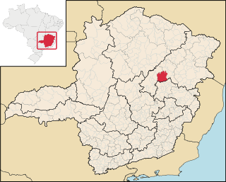
| Itamarandiba River | |
|---|---|
 | |
| Location | |
| Country | Brazil |
| Physical characteristics | |
| Source | |
| • location | Minas Gerais state |
The Itamarandiba River is a river of Minas Gerais state in southeastern Brazil.
| Itamarandiba River | |
|---|---|
| | |
| Location | |
| Country | Brazil |
| Physical characteristics | |
| Source | |
| • location | Minas Gerais state |
The Itamarandiba River is a river of Minas Gerais state in southeastern Brazil.
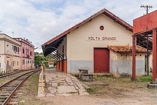
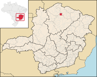
Volta Grande is a Brazilian municipality in the state of Minas Gerais. As of 2020 its population was estimated to be 5,261.

Biquinhas is a municipality in the north of the Brazilian state of Minas Gerais. As of 2020, the population was 2,498 in a total area of 457 square kilometers. It became a municipality in 1962.

Ubaí is a municipality in the north of the Brazilian state of Minas Gerais. As of 2020 the population was 12,599 in a total area of 821 km². It became a municipality in 1962.
Varzelândia is a municipality in the north of the Brazilian state of Minas Gerais. As of 2020 the population was 19,305 in a total area of 804 km². It became a municipality in 1962.
Grão Mogol is a Brazilian municipality located in the north of the state of Minas Gerais. In 2020 the population was 15,890 in a total area of 3,890 km2. The elevation is 829 meters. It became a municipality in 1840.

Raul Soares is a Brazilian municipality located in the state of Minas Gerais. The city belongs to the mesoregion of Zona da Mata and extends to the microregion of Ponte Nova. As of 2020, the estimated population was 23,711.

Vermelho Novo is a Brazilian municipality located in the state of Minas Gerais. The city belongs to the mesoregion of Zona da Mata and to the microregion of Ponte Nova. As of 2020, the estimated population was 4,846.
Paineiras is a municipality in the midwest of the Brazilian state of Minas Gerais. As of 2020, the population was 4,462 in a total area of 638 km². It became a municipality in 1962.

Matipó is a Brazilian municipality located in the state of Minas Gerais. The city belongs to the mesoregion of Zona da Mata and to the microregion of Manhuaçu. As of 2020, the estimated population was 19,005.

Pai Pedro is a municipality in the northeast of the Brazilian state of Minas Gerais. As of 2020 the population was 6,094 in a total area of 785 km2 (303 sq mi). The elevation is 520 meters (1,710 ft). It became a municipality in 1997. The postal code (CEP) is 39517-000.

Botumirim is a Brazilian municipality located in the north of the state of Minas Gerais. In 2020 the population was 6,288 in a total area of 1,572 km2. The elevation is 948 meters. It became a municipality in 1962.

Padre Carvalho is a Brazilian municipality located in the north of the state of Minas Gerais. In 2020 the population was 6,423 in a total area of 450 km². It became a municipality in 1997.
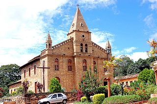
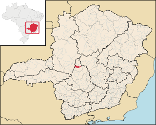
Itamarandiba is a Brazilian municipality located in the north-center of the state of Minas Gerais. Its population as of 2020 was 34,936 living in a total area of 2,736 km².

Jenipapo de Minas is a municipality in the northeast of the Brazilian state of Minas Gerais. As of 2020 the population was 7,738 in a total area of 284 km². The elevation of the town center is 521 meters. It is part of the IBGE statistical meso-region of Jequitinhonha and the micro-region of Capelinha. It became a municipality in 1997.

Veredinha is a municipality in the northeast of the Brazilian state of Minas Gerais. As of 2020 the population was 5,727 in a total area of 635 km². The elevation of the urban area is 635 meters. It is part of the IBGE statistical meso-region of Jequitinhonha and the micro-region of Capelinha. It became a municipality in 1995.

São Domingos do Prata is a Brazilian municipality located in the state of Minas Gerais. The city belongs to the mesoregion Metropolitana de Belo Horizonte and to the microregion of Itabira. As of 2020, the estimated population was 17,327.
Paulistas, Minas Gerais is a municipality in the state of Minas Gerais in the Southeast region of Brazil.
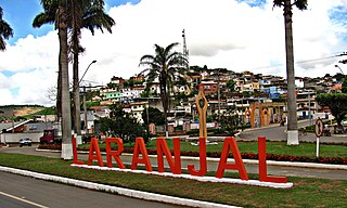
Laranjal, Minas Gerais is a municipality in the state of Minas Gerais in the Southeast region of Brazil.

Pirapetinga is a municipality in the state of Minas Gerais in the Southeast region of Brazil. Its estimated population in 2020 was 10,772 inhabitants (IBGE).
Senador Cortes is a municipality in the state of Minas Gerais in the Southeast region of Brazil.
Coordinates: 17°18′23″S42°48′04″W / 17.3065°S 42.8010°W