Obock is a small port town in Djibouti. It is located on the northern shore of the Gulf of Tadjoura, where it opens out into the Gulf of Aden. The town is home to an airstrip and has ferries to Djibouti City, while mangroves lie nearby. The French form Obock derives from Arabic "Oboh", deformation of Oboki, a name given to the Wadi Dar'i in its middle part, upstream of its coastal delta.
Tadjoura is one of the oldest town in Djibouti and the capital of the Tadjourah Region. The town evolved into an early Islamic center with the arrival of Muslims shortly after the hegira. An important port for many centuries, it was ruled by a succession of polities, including the Ifat Sultanate, Adal Sultanate, the Ottoman Empire, France until Djibouti's independence in 1977. Lying on the Gulf of Tadjoura, it is home to a population of around 45,000 inhabitants. It is the third largest city in the country after Djibouti City and Ali Sabieh.
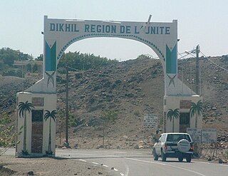
Dikhil is a town in the western Dikhil Region of Djibouti. Lying east of Lake Abbe, It is situated about 122 km (76 mi) southwest of Djibouti City and 12 km (7 mi) north of the border with Ethiopia. The town is home to a population of around 54,000 people. The town develops gardens and fruit trees. The climate in the city is characterized by high to very high temperatures.
Ali Sabieh is the second largest city in Djibouti. It is situated about 98 kilometres Southwest of Djibouti City and 10 km (6 mi) north of the border with Ethiopia. It sprawls on a wide basin surrounded by granitic mountains on all sides. The famous landmark of Ali Sabieh is located near the city.

Arta is a town in southeastern Djibouti. The center of the Arta Region, it is the country's sixth-largest city. As of 2010, the population was 11,043. Arta is situated on the Mountains of Arta and is famous for its mild climate. It is located some 41 kilometres west of the national capital, Djibouti City.

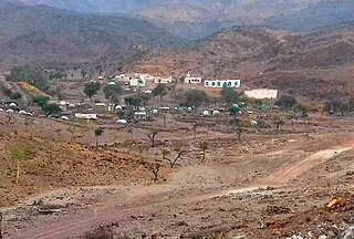
Alaili Dadda` is a town in northern Djibouti. It is situated about 68 kilometers north of Obock, at an elevation of 1,263 feet from sea-level. The town sprawls on a wide basin surrounded by granitic mountains on all sides. It is located in the Alaili Dadda district of the Obock region. N16 road is located on. to the nearest settlements, Khor Angar, Dadda'to and Obock. The capital city Djibouti to quite far, but close to the city outside the two major Dadda'to. Is the capital of Obock region. Khor Angar the second largest city in the region. Dadda Alaile the 4th largest in the region or 5th.

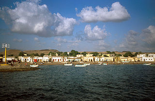
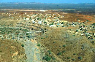
Khôr ‘Angar is a town in the northern Obock Region of Djibouti. It is situated on the west coast of the Bab el Mandeb Strait. The town is served by Herkale Airport, a desert airstrip 7 kilometres (4 mi) northwest.
Medeho is a town in the northeastern Obock Region of Djibouti. Medeho has one of the mildest climates in Djibouti, which is not always passable during the rainy season. The town is overlooked by Mabla Mountains, the fifth tallest mountain in Djibouti.
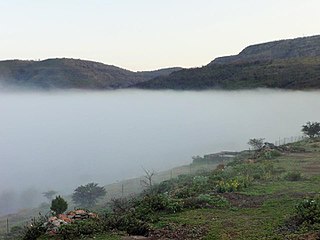
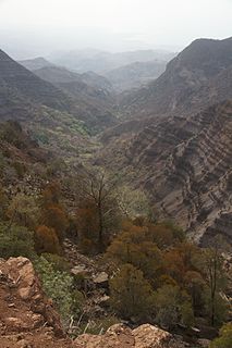
Airolaf is a town in the Tadjoura Region in northwestern Djibouti and in the centre of the Tadjoura Region. It is located some 115 kilometres southeast of the national capital, Djibouti City. Airolaf is known for its temperate, cool climate – the coolest area in Djibouti. The town is overlooked by Goda Mountains, the third tallest mountain in Djibouti. One of the distinctive features of Airolaf countryside is the widespread growing of vegetables.
Loyada is a small town in Djibouti. Located in the Arta Region, it is the only official border crossing from Djibouti into Somalia. It is situated on the west coast of Gulf of Aden, 25 kilometres (16 mi) from the capital, Djibouti City.
`As `Ela, As Eyla or Diksa, It is located around 160 kilometres southwest of the capital, Djibouti City, it has an estimated population of 684 people. It is located along the National Highway 6. Tourist richness which the crater formed Lake Abbe, As' Eyla Province is located within the boundaries.
Holhol is a town in the Ali Sabieh Region of Djibouti. It is located 44 kilometres south-west of the capital Djibouti City, at an altitude of 450m. Holhol enjoys a semi-arid climate. The surrounding district is rich in both livestock and fledgeling agriculture. It is notable for being the birthplace of Cheik Osman Waiss a nationalist and anti-colonial where he began his movement.

Randa is a town in central Djibouti located in Tadjoura. It is the capital of the Randa District. The settlement lies in a small valley, north of the Day Forest National Park in the Goda Mountains. It lies at the junction of two solely domestic roads, the N11 and N12. It is within 10 miles (16 km) of the national park.
Dorra is a village in Djibouti in the mid-north of Tadjoura Region, the largest region. It is about 237 kilometers north-west of Djibouti City and 65 km (40 mi) south of the border with Eritrea and east of the border with Ethiopia. At Dorra rock paintings have been found.
We`a or Wê‘a is a town in the Arta Region of Djibouti. It is located on the N1 road, which connects it to Djibouti City, located some 37 kilometres to the east. We`a is the second largest city in the Arta Region after Arta and before Damerjog. It is the primary transportation hub in western Djibouti via highway. The town is situated in a small valley.
Damerjog or Damerdjog is a small village located in eastern Djibouti, populated by farmers and gardeners, located in the Arta Region, 16 km southeast of the capital Djibouti, north of the border with Somalia.
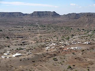
Adailou is a town in the Tadjoura region of Djibouti. It sprawls on a wide basin surrounded by granitic mountains on all sides. Adailou has one of the mildest climates in Djibouti, which is not always passable during the rainy season.
The Arta Mountains, also known as the Great Mountains of Arta, are a mountain range in Djibouti. They sit at an average elevation of 700 metres (2,300 ft) above sea level, is the tenth highest point in Djibouti. The mountains lie to the south of the Gulf of Tadjoura, in the Arta Region. They are situated approximately 35 kilometres (21 mi) west of the capital Djibouti City, and 69 kilometres (43 mi) by road from Ali Sabieh. The Issa Somali have a long history in the Arta Mountains.

Aysha is a town in Ethiopia. It is situated about 36 kilometres South of the border with Djibouti and 20 km West of the border with Somalia. Located in the Shinile Zone in the Somali Region. This town served by a station on the Addis Ababa - Djibouti Railway.