
Bulgaria is a country situated in Southeast Europe and occupies the eastern quarter of the Balkan peninsula, being the largest country within its geographic boundaries. It is bordering Romania to the north, Serbia and North Macedonia to the west, Greece and Turkey to the south, and the Black Sea to the east. The northern border with Romania follows the river Danube until the city of Silistra. The land area of Bulgaria is 110,994 square kilometres (42,855 sq mi), slightly larger than that of Iceland or the U.S. state of Tennessee. Considering its relatively small size, Bulgaria has a great variety of topographical features. Even within small parts of the country, the land may be divided into plains, plateaus, hills, mountains, basins, gorges, and deep river valleys. The geographic center of Bulgaria is located in Uzana.

The Studen Kladenets Reservoir is the third largest reservoir by volume in Bulgaria after Iskar Dam and Kardzhali Dam. It is situated on the river Arda, and is created behind the Studen Kladenets dam, 30 km south-east of the town of Kardzhali. There are another two dams of the Arda - Kardzhali Dam to the west (upstream) and Ivaylovgrad Dam to the east (downstream).

Lake Buchanan was formed by the construction of Buchanan Dam by the Lower Colorado River Authority to provide a water supply for the region and to provide hydroelectric power. Buchanan Dam, a structure over 2 mi (3.2 km) in length, was completed in 1939. Lake Buchanan was the first of the Texas Highland Lakes to be formed, and with 22,333 acres of surface water, it is also the largest. The surface of the lake includes area in both Burnet and Llano Counties. The lake is west of the city of Burnet, Texas.
Lake Mead is a man-made lake that lies on the Colorado River, about 24 mi (39 km) from the Las Vegas Strip, southeast of the city of Las Vegas, Nevada, in the states of Nevada and Arizona. It is the largest reservoir in the United States in terms of water capacity. Formed by the Hoover Dam on September 30, 1935, the reservoir serves water to the states of Arizona, California, and Nevada, as well as some of Mexico, providing sustenance to nearly 20 million people and large areas of farmland.

Pazardzhik Province is a province in Southern Bulgaria, named after its administrative and industrial centre - the city of Pazardzhik. The territory is 4,456.9 km2 (1,720.8 sq mi) that is divided into 12 municipalities with a total population of 275,548 inhabitants, as of February 2011.
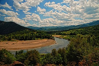
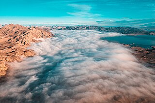
The Arda is a 290-kilometre-long (180 mi) river in Bulgaria and Greece. It is a tributary of the Maritsa. Its source lies in the Bulgarian Rhodope Mountains near the village Arda, part of the municipality of Smolyan. It flows eastward past Rudozem, Kardzhali and Ivaylovgrad and enters Greece in the northern part of the Evros regional unit. It flows into the Maritsa on the border of Greece and Turkey, between the Greek village Kastanies and the Turkish city Edirne. In the Bulgarian section there are three hydroelectric and irrigation dams, Kardzhali Dam, Studen Kladenets and Ivaylovgrad Dam. The Bulgarian section is 229 kilometres (142 mi) long, making the Arda the longest river in the Rhodopes. The medieval Dyavolski most arch bridge crosses the river 10 kilometres (6 mi) from Ardino.

Rila is the highest mountain range of Bulgaria and the Balkan Peninsula. It is situated in southwestern Bulgaria and forms part of the Rila–Rhodope Massif. The highest summit is Musala at an altitude of 2,925 m which makes Rila the sixth highest mountain range in Europe after the Caucasus, the Alps, Sierra Nevada, the Pyrenees and Mount Etna, and the highest one between the Alps and the Caucasus. It spans a territory of 2,629 km2 with an average altitude of 1487 m. The mountain is believed to have been named after the river of the same name, which comes from the Old Bulgarian verb "рыти" meaning "to grub".

The Iskar is a right tributary of the Danube. With a length of 368 km it is the longest river that runs entirely within Bulgaria. Originating as three forks in Balkan's highest mountain range Rila, it flows in northern direction until its confluence with the Danube River. As it flows northwards it fuels the largest artificial lake in the country, the Iskar Reservoir, forms the divide between the Vitosha and Plana Mountains in the west and the Sredna Gora mountain range in the east before entering the Sofia Valley, which contains the nation's capital Sofia. From there the Iskar runs through the Balkan Mountains forming the spectacular 84 km long Iskar Gorge and as it crosses the mountains its water course turns in north-eastern direction at Lakatnik. North of the Balkan Mountains the river crosses the Danubian Plain and finally flows into the Danube between the villages of Baykal and Gigen. Geologically, Iskar is the oldest river in the Balkan Peninsula.
Lake Georgetown is a reservoir on the north fork of the San Gabriel River in central Texas in the United States. Lake Georgetown is a U.S. Army Corps of Engineers reservoir formed on the San Gabriel by the North San Gabriel Dam, which is located about three miles west of Georgetown, Texas. The dam, lake, and all adjacent property are managed by the Fort Worth District of the U.S. Army Corps of Engineers. The dam was officially completed on October 5, 1979, and serves to provide flood control for the community of Georgetown. Lake Georgetown is also a source of drinking water for Georgetown and the nearby city of Round Rock. The lake is also a popular recreational destination.

The Batak Reservoir is located in the Rhodope Mountains and is the third largest in Bulgaria. It attracts many tourists and fishermen, and the resort Tsigov Chark was built on its shore. The lake is situated around 8 km away from the historic town of Batak from which it took its name. Additionally, in close proximity are the cities of Rakitivo (14 km) and Velingrad (24 km). The Batak reservoir is located in the Batak municipality and within the Pazardzhik province. The dam is positioned at around 1,100 m above the sea level. The reservoir area is surrounded by mountain and forest areas.

The Whiskeytown–Shasta–Trinity National Recreation Area is a United States National Recreation Area in northern California.

Kyprinos is a town and a former municipality in the Evros regional unit, East Macedonia and Thrace, Greece. Since the 2011 local government reform it is part of the municipality Orestiada, of which it is a municipal unit. The municipal unit has an area of 135.976 km2. In 2011 its population was 806 for the village and 2,226 for the municipal unit. Kyprinos is located southwest of Edirne, Turkey, west-northwest of Orestiada, north of Alexandroupoli and about 5 to 6 km east of Kurdzhali and the Bulgarian frontier, where there is a border crossing. Athens is approximately 1,050 km to the southwest. Komara is on the other side of the river Ardas.

Ivaylovgrad is a town in Haskovo Province in the south of Bulgaria set near the river Arda in the easternmost part of the Rhodope Mountains, and is the administrative centre of the homonymous Ivaylovgrad Municipality. The border with Evros, Greece is around two miles from the town centre. As of December 2009, the town has a population of 3,756 inhabitants.

Maharana Pratap Sagar, in India, also known as Pong Reservoir or Pong Dam Lake was created in 1975, by building the highest earthfill dam in India on the Beas River in the wetland zone of the Siwalik Hills of the Kangra district of the state of Himachal Pradesh. Named in the honour of Maharana Pratap (1540–1597), the reservoir or the lake is a well-known wildlife sanctuary and one of the 27 international wetland sites declared in India by the Ramsar Convention. The reservoir covers an area of 24,529 hectares, and the wetlands portion is 15,662 hectares.

Silverwood Lake is a large reservoir in San Bernardino County, California, United States, located on the West Fork Mojave River, a tributary of the Mojave River in the San Bernardino Mountains. It was created in 1971 as part of the State Water Project by the construction of the Cedar Springs Dam as a forebay on the 444-mile (715 km) long California Aqueduct, and has a capacity of 73,000 acre feet (90,000,000 m3).
Lyutitsa is one of the largest and best preserved castles in the easternmost part of the Eastern Rhodopes, located 3.5 hours' walk south-west of Ivaylovgrad, in southernmost Bulgaria. It is also known as the "Marble City" because its walls are made of white marble.

Vlasina Lake is a semi-artificial lake in Southeast Serbia. Lying at an altitude of 1,211 metres (3,973 ft), with an area of 16 square kilometres (6.2 sq mi), it is the highest and largest artificial lake in Serbia. It was created in 1947–51 when the peat bog Vlasinsko blato was closed off by a dam and submerged by the waters of incoming rivers, chiefly the Vlasina.
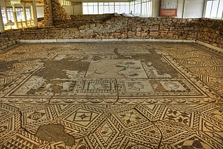
Villa Armira is a 1st-century suburban Roman villa in southeastern Bulgaria, located in the proximity of Ivaylovgrad, Haskovo Province. Discovered in 1964 during reservoir construction, it is a primary historical attraction to the Ivaylovgrad area. It is classified as a monument of culture of national importance.

The Ivaylovgrad Dam(язовир "Ивайловград") is located in the eastern Rhodope Mountains and is situated on the Arda river, Southern Bulgaria. There are another two large dams of the Arda upstream - Kardzhali Dam and Studen Kladenets Dam to the west of Ivaylovgrad Dam.

Ticha Reservoir is a reservoir in Varbitsa Municipality, Shumen Province, northeastern Bulgaria, located to the north and northeast of the town of Varbitsa. It is one of the largest lakes of Bulgaria. The Ticha Dam is located in the northeastern part of the reservoir, in the southeastern part of Kotel Mountain.

