
Protected areas or conservation areas are locations which receive protection because of their recognized natural or cultural values. Protected areas are those areas in which human presence or the exploitation of natural resources is limited.

Man and the Biosphere Programme (MAB) is an intergovernmental scientific program, launched in 1971 by UNESCO, that aims to establish a scientific basis for the 'improvement of relationships' between people and their environments.
Jebel Musa, Jabal Moussa or Gebel Musa may refer to:
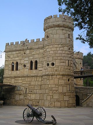
Moussa Castle is a castle between Deir el Qamar and Beit ed-Dine in Lebanon.

Joub Jannine is a city located in the Beqaa Valley in Lebanon.

Keserwan District is a district (qadaa) in Keserwan-Jbeil Governorate, Lebanon, to the northeast of Lebanon's capital Beirut. The capital, Jounieh, is overwhelmingly Maronite Christian. The area is home to the Jabal Moussa Biosphere Reserve.
Mount Sannine is a mountain in the Mount Lebanon range. It is situated within the Keserwan District of Lebanon. Its highest point is 2,628 m above sea level in Lebanon. Mount Sannine, which has a base of limestone, is the source of many mountain springs. There is an old 4th-century Christian church situated at the peak of the mountain. The city of Beirut and the Mediterranean Sea can be seen from the top of the mountain.
The Manasseh Hills or hill country of Manasseh, directly derived from Hebrew: Menashe Heights, called Bilad ar-Ruha in Arabic, meaning "Land of Winds", is a geographical region in northern Israel, located on the Carmel Range, between Mount Carmel and Mount Amir/Umm al-Fahm.
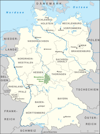
The Rhön Biosphere Reserve includes the entire central area of the Rhön Mountains, a low mountain range in the German states of Hesse, Bavaria and Thuringia.
Under UNESCO's Man and the Biosphere Programme, there are 31 biosphere reserves recognised as part of the World Network of Biosphere Reserves in the African States and Arab States. These are distributed across 12 countries in the region as of March 2018.

Ebersberg is a mountain in the Hessian Rhön, part of the Rhön Mountains in Hesse, Germany. It rises to an elevation of 689 meters above sea level and is located within the Hessische Rhön Nature Park.

Giam Siak Kecil-Bukit Batu Bioreserve is a peatland area in Riau Province of Sumatra, covering 705,271 hectares (2,723.07 sq mi) and large parts of Bengkalis Regency and Siak Regency. It is a declared UNESCO Man and the Biosphere Reserve and supports a sustainable timber industry. It is home to two wildlife reserves, namely Giam Siak Wildlife Reserve and Bukit Batu Wildlife Reserve; flagship species include the Sumatran elephant and Sumatran tiger.
Biosphere reserves are established according to the UNESCO's Man and the Biosphere Programme (MAB) to promote sustainable development for conservation of biological and cultural diversity. As of 2016, the Lal Suhanra Biosphere Reserve and Ziarat Juniper Forest are the only two biosphere reserve in Pakistan, which were approved by UNESCO in 1977 and 2013 respectively. A number of initiatives and projects have been undertaken to promote and develop other biosphere reserves in Pakistan but due to weak implementation this has not yet been materialized. In July 2012, Pakistan Museum of Natural History and Beijing Museum of Natural History signed a MoU to work on trans-boundary biodiversity and to improve MAB related activities in the Karakoram, Himalaya, and Hindukush regions.
The Zahrani is a river in Southern Lebanon. It is located south of Sidon. Zahrani (زهراني) is the adjective form of the noun Zahran (زهران), which means flowering or blossoming in Arabic. This river irrigates most of Jabal Rihane and Nabatiyeh areas. It is considered one of the most important rivers of the Jabal Rihane area. Its mouth is located north of the mouth of the (longer) Litani River.
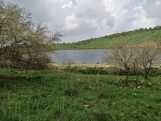
Jabal Moussa Biosphere Reserve is a nature reserve located in the Keserwan District of Lebanon, on the shoulders of the western slopes of Mount Lebanon overlooking the Mediterranean Sea to the West. It covers an area of 6500 hectares, at an altitude ranging between 350 meters in the North-West and 1,700 meters to the South-East. Its main villages are: Yahchouch, Qahmez, Jouret el-Termos, Nahr ed Dahab, Ghbaleh, Ebreh, and Chouwan. Jabal Moussa and surrounding villages became part of the UNESCO Network of Biosphere Reserves under the Man and Biosphere (MAB) program in 2009. As part of the MAB program, JMBR addresses human livelihood improvement and nature conservation through combining natural sciences with social sciences, economics and education.
Omayed is a 75,800 ha UNESCO designated Biosphere Reserve in western Egypt in a sparsely populated region of coastal desert 80 kilometers west of Alexandria and 200 kilometers east of Matruh. It was designated as a biosphere reserve in 1981 and extended in 1998. The area includes four villages with a total 400 inhabitants. Habitats include coastal calcareous dunes, inland ridges, saline depressions, nonsaline depressions and inland plateau. The area provides important moss habitat. The Khashm El-Aish plateau in Omayed Protected Area (OPA) is home to 29 moss taxa recorded for the first time from Mediterranean coast, Egypt and 16 of them new records to the western Mediterranean coast. OPA includes 0.07% of Egypt's land mass but is home to more than 17 percent of its moss flora.
Forests cover 13.6% of Lebanon, and other wooded lands represents 11%. Since 2011, more than 600,000 trees, including cedars and other native species, have been planted throughout Lebanon as part of the Lebanon Reforestation Initiative (LRI). More reforestation efforts are needed. For example, the 40 hectares of Cedrus libani at Al Shouf Cedar Nature Reserve could be expanded to 3,000 hectares. The Friends of the Cedar Forest Committee planted 200,000 cedars, with 180,000 surviving. The Committee goal was to create a corridor connecting the cedar forests o of Bcharre, Ehden, and Tannourine with each other to create an ecosystem in order to make the forests more resilient to future environmental pressures.

Keserwan-Jbeil is the most recently created governorate of Lebanon. It consists of the districts of Jbeil and Keserwan. Keserwan-Jbeil covers an area of 722 km2 (279 sq mi) and is bounded by the North Governorate to the north, the Baalbek-Hermel Governorate to the east, the Mount Lebanon Governorate to the south, and the Mediterranean Sea to the west. The capital is at Jounieh.

Qahmez is a village with no municipality located in the Jurd area of the district of Byblos of the Keserwan-Jbeil Governorate in central Lebanon. It is located 50 kilometers northeast of Beirut. Its elevation ranges between 700 and 1800 meters above sea level and its total land area consists of 1,253 hectares.
