
The Marshall Islands, officially the Republic of the Marshall Islands, is an island country west of the International Date Line and north of the equator in the Micronesia region in the Northwestern Pacific Ocean. The territory consists of 29 coral atolls and five islands, divided across two island chains: Ratak in the east and Ralik in the west. 97.87% of its territory is water, the largest proportion of water to land of any sovereign state. The country shares maritime boundaries with Wake Island to the north, Kiribati to the southeast, Nauru to the south, and the Federated States of Micronesia to the west. The capital and largest city is Majuro, home to approximately half of the country's population.
Austronesian settlers arrived in the Marshall Islands in the 2nd millennium BC, but there are no historical or oral records of that period. Over time, the Marshallese people learned to navigate over long ocean distances by walap canoe using traditional stick charts.
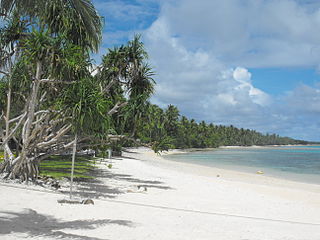
Majuro is the capital and largest city of the Marshall Islands. It is also a large coral atoll of 64 islands in the Pacific Ocean. It forms a legislative district of the Ratak (Sunrise) Chain of the Marshall Islands. The atoll has a land area of 9.7 square kilometers (3.7 sq mi) and encloses a lagoon of 295 square kilometers (114 sq mi). As with other atolls in the Marshall Islands, Majuro consists of narrow land masses. It has a tropical trade wind climate, with an average temperature of 27 °C (81 °F).
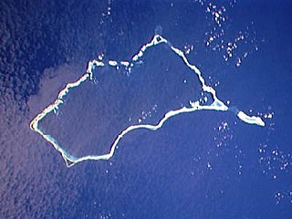
Mili Atoll is a coral atoll of 92 islands in the Pacific Ocean, and forms a legislative district of the Ratak Chain of the Marshall Islands. It is located approximately 78 kilometers (48 mi) southeast of Arno. Its total land area is 14.9 square kilometers (5.8 sq mi) making it the second largest of the Marshall Islands after Kwajalein.

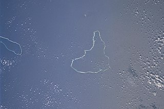
Jaluit Atoll is a large coral atoll of 91 islands in the Pacific Ocean and forms a legislative district of the Ralik Chain of the Marshall Islands. Its total land area is 11.34 square kilometers (4.38 sq mi), and it encloses a lagoon with an area of 690 square kilometers (270 sq mi). Most of the land area is on the largest islet (motu) of Jaluit (10.4 km2). Jaluit is approximately 220 kilometers (140 mi) southwest of Majuro. Jaluit Atoll is a designated conservation area and Ramsar Wetland.
Ailinglaplap or Ailinglapalap is a coral atoll of 56 islands in the Pacific Ocean, and forms a legislative district of the Ralik Chain in the Marshall Islands. It is located 152 kilometres (94 mi) northwest of Jaluit Atoll. Its total land area is only 14.7 square kilometers (5.7 sq mi), but it encloses a lagoon of 750 square kilometers (290 sq mi). The economy of the atoll is dominated by coconut plantations. The population of the atoll was 1,175 in 2021. Jabat Island is located off the coast of Ailinglaplap Atoll. The former president of the Marshall Islands, Kessai Note, was born on Jeh Island, Ailinglaplap Atoll.

Kili Island or Kili Atoll is a small, 81 hectares island located in the Marshall Islands in the Pacific Ocean. As of 2021, 415 people lived on the island, many of whom were descended from islanders who originally lived on Bikini Atoll. They were relocated when they agreed to let the U.S. government temporarily use their home for nuclear testing in 1945. Kili Island became their home after two prior relocations failed. The island does not have a natural lagoon and cannot produce enough food to enable the islanders to be self-sufficient. It is part of the legislative district of the Ralik Chain of the Marshall Islands. The island is approximately 48 kilometers (30 mi) southwest of Jaluit. It is a good sized island for the Marshall Islands, but it is not an atoll with a lagoon.

Ebon Atoll is a coral atoll of 22 islands in the Pacific Ocean, forming a legislative district of the Ralik Chain of the Marshall Islands. Its land area is 5.75 square kilometers (2.22 sq mi), and it encloses a deep lagoon with an area of 104 square kilometers (40 sq mi). A winding passage, the Ebon Channel, leads to the lagoon from the southwest edge of the atoll. Ebon Atoll is approximately 155 kilometers (96 mi) south of Jaluit, and it is the southernmost land mass of the Marshall Islands, on the southern extremity of the Ralik Chain. In documents and accounts from the 1800s, it was also known as Boston, Covell's Group, Fourteen Islands, and Linnez.
Jabat Island is an island in the Pacific Ocean, and forms a legislative district of the Ralik Chain of the Marshall Islands. Its total land area is only 0.6 square kilometers (0.23 sq mi), and has a length of 1.2 kilometers (0.75 mi). It is located 12 kilometers (7.5 mi) from Ailinglapalap Atoll. Unlike most of the other islands in the Marshall Islands, Jabat Island is a rocky island rather than a coral atoll, although it surrounded by fringing shallow water coral reefs that extend for several kilometres beyond the outer reef to the north and south. The population of Jabat Island was 75 in 2021.

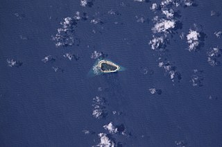
Namdrik Atoll or Namorik Atoll is a coral atoll of two islands in the Pacific Ocean, and forms a legislative district of the Ralik Chain of the Marshall Islands. Its total land area is only 2.8 square kilometers (1.1 sq mi), but it encloses a lagoon with an area of 8.4 square kilometers (3.2 sq mi). The atoll had a population of 299 at the 2021 census.

Namu Atoll is a coral atoll of 54 islands in the Pacific Ocean, and forms a legislative district of the Ralik Chain of the Marshall Islands. Its total land area is only 6.27 square kilometers (2.42 sq mi), but that encloses a lagoon of 397 square kilometers (153 sq mi). It is located approximately 62 kilometers (39 mi) south-southwest of Kwajalein Atoll.
Jaluit Airport is a public use airstrip located one nautical mile (1.85 km) southwest of the village of Jabor on Jaluit Atoll, Marshall Islands. This airstrip is assigned the location identifier N55 by the FAA and UIT by the IATA.

Iroij Litokwa Tomeing was the President of the Marshall Islands from January 2008 until October 2009.
Japanese settlement in the Marshall Islands was spurred on by Japanese trade in the Pacific region. The first Japanese explorers arrived in the Marshall Islands in the late 19th century, although permanent settlements were not established until the 1920s. As compared to other Micronesian islands in the South Seas Mandate, there were fewer Japanese who settled in the islands. After the Japanese surrender in 1945, the Japanese populace were repatriated to Japan, although people of mixed Japanese–Marshallese heritage remained behind. They form a sizeable minority in the Marshall Islands' populace, and are well represented in the corporate, public and political sectors in the country.

Delap-Uliga-Djarrit is an urban area in Majuro, the capital and the largest city of the Marshall Islands, with 15,846 people out of Majuro's 23,676. It consists of the districts of Delap, Uliga, and Djarrit. DUD is located on the eastern end of Majuro Atoll. Marshallese government buildings are situated in DUD.

Casten Ned Nemra is a Marshallese politician who was President of the Marshall Islands for 17 days in January 2016. He was elected by the Nitijeļā (Parliament) as President in January 2016, following the 2015 general election, narrowly defeating Senator Alvin Jacklick, a seven-term member of Parliament, by a 17–16 vote. He was the youngest person to hold the job and the second commoner. He was ousted by a vote of no confidence after just two weeks in office by the opposition for jumping ship and joining Iroij Mike Kabua's Aelon Kein Ad party along with Senators Dennis Momotaro and Daisy-Alik Momotaro.

Republic of Marshall Islands Public School System (PSS) is the public school system of the Marshall Islands, headquartered in Majuro. It was established in November 2013 by Public Law 2013-23.
Jaluit High School (JHS) is a secondary school in Jabor, Jaluit Atoll, Marshall Islands. It is a part of the Marshall Islands Public School System.

Hernsheim & Co was a German trading company in the Western Pacific Ocean with main offices on Yap, Jaluit and Matupi. The company was specialized in the copra export to Europe and tried after the loss of their possessions in the South Seas (1918), a new beginning in the French Mandate area of Cameroon. In the heyday of their South Sea business, Hernsheim & Co exported almost 30% of the copra produced in the Western Pacific Ocean. Many of their agents were also dealers in ethnographic objects.

Naval Base Marshall Islands were United States Navy advance bases built on the Marshall Islands during World War II to support the Pacific War efforts. The bases were built by US Navy after the Marshall Islands campaign that captured the islands from the Empire of Japan. By February 1944 the United States Armed Forces had captured the islands. Most of the airfields and other facilities Japan had built were destroyed in allied bombing raids and naval bombardment. US Navy Seabee Construction Battalions arrived as soon as the area was secured and remove the debris. The Seabees quickly repaired, built and improved the airfield/runways and seaport. Seabees often worked around the clock to get airfields operational so that fighter aircraft and bombers could start operating. The bases were used for staging upcoming campaigns and for repair.
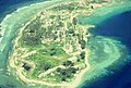 Oblique aerial photo of 1978, from north
 German 1906 map of Jaluit Atoll, with map inset of Jabor
