Jacob Flowers

Last updated

Jacob Flowers was an early white 19th century settler in Larimer County, Colorado. He was the founder of the town of Bellvue northwest of Fort Collins.

Larimer County, Colorado County in the United States

Larimer County is one of the 64 counties in the U.S. state of Colorado. As of the 2010 census, the population was 299,630. The county seat and most populous city is Fort Collins. The county was named for William Larimer, Jr., the founder of Denver.

Bellvue, Colorado Unincorporated community in State of Colorado, United States

Bellvue is an unincorporated community and U.S. Post Office in Larimer County, Colorado. It is a small agricultural community located in Pleasant Valley, a narrow valley just northwest of Fort Collins near the mouth of the Poudre Canyon between the Dakota Hogback ridge and the foothills of the Rocky Mountains. The ZIP Code of the Bellvue Post Office is 80512.

Fort Collins, Colorado Home Rule Municipality in Colorado, United States

Fort Collins is the Home Rule Municipality that is the county seat and the most populous municipality of Larimer County, Colorado, United States. Situated on the Cache La Poudre River along the Colorado Front Range, Fort Collins is located 56 mi (90 km) north of the Colorado State Capitol in Denver. With a 2016 estimated population of 161,000, it is the fourth most populous city in Colorado after Denver, Colorado Springs, and Aurora. Fort Collins is a midsize college city, home to Colorado State University.

Biography

Prior to the American Civil War, Flowers owned and operated three river boats along the Ohio River carrying passengers between Marietta, Ohio and St. Louis, Missouri. After two of his boats were destroyed in a sudden storm, he took the remaining boat and sailed down the Ohio to St. Louis, then up the Missouri River to Kansas City, Kansas, where he settled with his family in Wyandotte (now part of Kansas City). In 1873 he organized the Wyandotte Colony, a party of settlers, and led them west to the Colorado Territory to settle at the Union Colony at Greeley, which had been founded three years early as a religiously-oriented agricultural cooperative.

American Civil War Civil war in the United States from 1861 to 1865

The American Civil War was a war fought in the United States from 1861 to 1865, between the North and the South. The Civil War is the most studied and written about episode in U.S. history. Primarily as a result of the long-standing controversy over the enslavement of black people, war broke out in April 1861 when secessionist forces attacked Fort Sumter in South Carolina shortly after Abraham Lincoln had been inaugurated as the President of the United States. The loyalists of the Union in the North proclaimed support for the Constitution. They faced secessionists of the Confederate States in the South, who advocated for states' rights to uphold slavery.

Ohio River river in the midwestern United States

The Ohio River is a 981-mile (1,579 km) long river in the midwestern United States that flows southwesterly from western Pennsylvania south of Lake Erie to its mouth on the Mississippi River at the southern tip of Illinois. It is the second largest river by discharge volume in the United States and the largest tributary by volume of the north-south flowing Mississippi River that divides the eastern from western United States. The river flows through or along the border of six states, and its drainage basin includes parts of 15 states. Through its largest tributary, the Tennessee River, the basin includes several states of the southeastern U.S. It is the source of drinking water for three million people.

Marietta, Ohio City in Ohio, United States

Marietta is a city in and the county seat of Washington County, Ohio, United States. During 1788, pioneers to the Ohio Country established Marietta as the first permanent settlement of the new United States in the Territory Northwest of the River Ohio. Marietta is located in southeastern Ohio at the mouth of the Muskingum River at its confluence with the Ohio River. The population was 14,085 at the 2010 census.

Flowers was not contented at the Union Colony, however, and he relocated later that year upstream on the Cache la Poudre River to just west of Fort Collins, in an area just west of the Dakota Hogback known as Pleasant Valley. The valley had been settled by white homesteaders starting in 1860, and the area just south of the town near Stout (under present-day Horsetooth Reservoir) was the location of stone quarries developed by the Union Pacific Railroad. Flowers established and platted the town of Bellvue in the valley. In 1880, Flowers founded a general store in Bellvue to cater to the quarry workers and their families. He built a one-story sandstone building to house a general store. The building, which still stands, later became the local meeting of the Grange in the 20th century and today is known as the "Bellvue Grange". On June 24, 1884, he opened the first post office in Bellvue at his store. Flowers also built a horse racing track and grandstand for community gathers, dog and pony shows, and traveling medicine shows. He developed and garden and raised pigs for unfortunate families of quarry workers, a generosity that earned him the name "Uncle Jacob" in the local press during his lifetime.

Cache la Poudre River river in the United States of America

The Cache la Poudre River, also known as the Poudre River, is a river in the state of Colorado in the United States.

Dakota Hogback

The Dakota Hogback is a long hogback ridge at the eastern fringe of the Rocky Mountains that extends north-south from southern Wyoming through Colorado and into northern New Mexico in the United States. The ridge is prominently visible as the first line of foothills along the edge of the Great Plains. It is generally faulted along its western side, and varies in height, with gaps in numerous locations where rivers exit the mountains. The ridge takes its name from the Dakota Formation, a sandstone formation that underlies the ridge. The hogback was formed during the Laramide orogeny, approximately 50 million years ago, when the modern Rockies were created. The general uplift to the west created long faulting in the North American Plate, resulting in the creation of the hogback.

Stout, Colorado human settlement in United States of America

Stout is a former town in southern Larimer County, Colorado in the United States. The town was located in foothills southwest of Fort Collins, just west of the Dakota Hogback. It was established in the 1860s as a camp for workers at the nearby stone quarries in the area. The Union Pacific Railroad invested in quarrying operation in the valley around the town, and at one time Colorado and Southern Railway built a spur of their rail line from Fort Collins up to the town in order to transport stone for its own use. During its time of operation, Stout was also as a spot for the residents of the nearby town of Fort Collins to buy libations. Fort Collins had a 70 year old prohibition, preventing them from acquiring alcohol in their own. Due to transportation routes made for the stone quarry, it was easy for residents of Fort Collins to travel to Stout. These trips would end in excessive drunkenness, causing outrage from Fort Collins and Stout city officials, who worried about drunk drivers being a danger on the roads.

He also surveyed a road through the foothills west of Bellvue south of Rist Canyon. The road was widely used for passage along the south bank of the Poudre River, as well as to access the timber in the foothills. The road was eventually extended over Lulu Pass and became known as the Flowers Road. It fell into disuse after the construction of present-day State Highway 14 through the Poudre Canyon. The road is sporadically marked as a foot trail through the foothills in the Roosevelt National Forest.

Colorado State Highway 14 highway in Colorado

State Highway 14 in the U.S. state of Colorado is an east–west state highway approximately 237 miles (381 km) long. One of the longest state highways in Colorado, it traverses four counties along the northern edge of the state, spanning a geography from the continental divide in the Rocky Mountains to the Great Plains, and including North Park, the Poudre Canyon, and the Pawnee National Grassland. It provides the most direct route from Fort Collins westward via Cameron Pass to Walden and Steamboat Springs, and eastward across the plains to Sterling.

Poudre Canyon

The Poudre Canyon is a narrow verdant canyon, approximately 40 mi (64 km) long, on the upper Cache la Poudre River in Larimer County, Colorado in the United States. The canyon is a glacier-formed valley through the foothills of the Front Range of the Rocky Mountains northwest of Fort Collins.

Roosevelt National Forest

The Roosevelt National Forest is a National Forest located in north central Colorado. It is contiguous with the Colorado State Forest as well as the Arapaho National Forest and the Routt National Forest. The forest is administered jointly with the Arapaho National Forest and the Pawnee National Grassland from offices in Fort Collins, and is denoted by the United States Forest Service as ARP.

Related Research Articles

Laporte, Colorado CDP in Colorado, United States

Laporte is a census-designated place (CDP) in Larimer County, Colorado, United States. The population was 2,691 at the 2000 census. The Laporte Post Office has the ZIP Code 80535.

Benjamin Harrison Eaton Union Army officer

Benjamin Harrison Eaton was an American politician, entrepreneur and agriculturalist in the late 19th and early 20th century. Eaton was a founding officer of the Greeley Colony and was instrumental in the establishment of modern irrigation farming to Northern Colorado. A member of the Republican Party, he served as the fourth Governor of Colorado, from January 1885 to January 1887, with the nickname of the "farmer governor". He was one of the largest land owners in Weld and Larimer counties, at one time owning over ninety 160 acre (0.6 km²) parcels, all watered from canals and reservoirs of his own construction. His projects were influential in helping turn the South Platte River valley into an important agricultural region in the state's economy. The town of Eaton, Colorado in western Weld County is named for him.

The Colorado Piedmont is an area along the base of the foothills of the Front Range in north central Colorado in the United States. The region consists of a broad hilly valley, just under 5000 ft in elevation, stretching north and northeast from Denver in the valley of the South Platte River, as well as along the Arkansas River valley southward from Colorado Springs. The region includes much of the populated and cultivated area of Colorado. The name Colorado Piedmont also refers to the physiographic section of the Great Plains province.

Horsetooth Reservoir

Horsetooth Reservoir is a large reservoir in southern Larimer County, Colorado, just west of the city of Fort Collins, Colorado. The reservoir sits in the foothills above the town on the western side of the Dakota Hogback, which contains the reservoir along its eastern side. The reservoir runs north-south for approximately 6.5 miles (10 km) and is approximately one-half mile (1 km) wide. It was constructed in 1949 by the Bureau of Reclamation as part of its federal Colorado-Big Thompson Project or "C-BT". Water distribution is currently managed by Reclamation and operated by the Northern Colorado Water Conservancy District. Horsetooth and Carter Lake serve as the two principal reservoirs for water diverted eastward under the continental divide via the C-BT.

The Greeley, Salt Lake and Pacific Railway was a railroad that operated in northern Colorado in the United States during the 1880s. Founded with heavy backing with the Union Pacific Railroad, it was controlled by the Union Pacific from its inception, but was incorporated into the new Colorado and Southern Railway in 1898, becoming part of the Chicago, Burlington and Quincy Railroad in 1908.

The Fort Collins Agricultural Colony was a 19th-century enterprise in Larimer County, Colorado to promote new agricultural and commercial settlement in and around the town of Fort Collins. Founded in the autumn of 1872 as an outgrowth of the Union Colony in nearby Greeley, the colony was instrumental in the early growth of Fort Collins, as well as in making it an agricultural center in the Colorado Territory at a time when the region was still known primarily for its mineral resources.

The Union Colony of Colorado was a 19th-century private enterprise formed to promote agricultural settlements in the South Platte River valley in the Colorado Territory. Organization of the colony began in October 1869 by Nathan Meeker in order to establish a religiously oriented utopian community of "high moral standards". The colony was founded in March 1870 at the site of present-day Greeley, Colorado. Union Colony was financially backed and promoted by New York Tribune editor, Horace Greeley, a prominent advocate of the settlement of the American West. The homesteaded colony greatly advanced irrigation usage in present-day northern Colorado, demonstrating the viability of cultivation at a time when agriculture was emerging as a rival to mining as the principal basis for the territorial economy.

Antoine Janis fur trader and homesteader

Antoine Janis was a 19th-century French-American fur trader and an early white homesteader in Larimer County, Colorado, in the United States. The first recorded permanent white settler in northern Colorado, he founded the town of Laporte in 1858.

Camp Collins was a 19th-century outpost of the United States Army in the Colorado Territory. The fort was commissioned in the summer of 1862 to protect the Overland Trail from attacks by Native Americans in a conflict that later became known as the Colorado War. Located along the Cache la Poudre River in Larimer County, it was relocated from its initial location near Laporte after a devastating flood. Its second location downstream on the Poudre was used until 1866 and became the nucleus around which the City of Fort Collins was founded.

Kinikinik, Colorado human settlement in Colorado, United States of America

Kinikinik is a small unincorporated community in western Larimer County, Colorado in the United States. It is located along State Highway 14 in the upper Poudre Canyon west of Fort Collins on the east side of Cameron Pass. The community consists of a general store and neighboring summer mountain resorts and vacation homes. The activities include fishing in the Cache la Poudre River and hiking in the nearby mountains in the Roosevelt National Forest. The community was named for the kinnikinick plant by early settlers.

The North Fork Cache la Poudre River is a tributary of the Cache la Poudre River, approximately 59.2 miles (95.3 km) long, in north central Colorado in the United States. It drains a mountainous area of north central Larimer County northwest of Fort Collins on the western side of the Laramie Foothills.

High Park fire

The High Park fire was a wildfire in the mountains west of Fort Collins in Larimer County, Colorado, United States. It was caused by a lightning strike and was first detected on the morning of June 9, 2012. It was declared 100 percent contained on June 30, 2012, and all associated evacuation orders were lifted.

Poudre City is a ghost town located in the foothills of the Rocky Mountains in northwestern Larimer County, Colorado, United States. The town was founded in 1890 around a gold reducing stamp mill. The town was destroyed on June 10, 1891 when the Chambers Lake dam burst and swept down the Poudre Canyon. All that remains of the town today is the chimney from the stamp mill.

Goat Hill (Larimer County, Colorado)

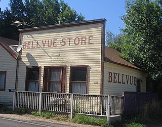
Goat Hill—also called Bellvue Dome—is a dome in Larimer County, Colorado near Bellvue.

References

International Standard Book Number Unique numeric book identifier

The International Standard Book Number (ISBN) is a numeric commercial book identifier which is intended to be unique. Publishers purchase ISBNs from an affiliate of the International ISBN Agency.