Related Research Articles

A phantom island is a purported island which was included on maps for a period of time, but was later found not to exist. They usually originate from the reports of early sailors exploring new regions, and are commonly the result of navigational errors, mistaken observations, unverified misinformation, or deliberate fabrication. Some have remained on maps for centuries before being "un-discovered."

The Arctic Archipelago, also known as the Canadian Arctic Archipelago, is an archipelago lying to the north of the Canadian continental mainland, excluding Greenland and Iceland.
Torch Lake Township is a civil township of Houghton County in the U.S. state of Michigan. As of the 2010 census, the population of the township was 1,880. The township was established in 1886 and is one of the largest townships in Houghton County by area. It is surrounded by the Torch Lake, the Portage Lake, and Lake Superior. As well as a large number of unincorporated communities, the township also includes a portion of the Baraga State Forest which lies along the shores of Keweenaw Bay. The township borders Schoolcraft Township to the north, Osceola Township to the northwest, and Chassell Township to the southwest. The community of Hubbell serves as the major population center of the township, as well as hosting the Township Hall itself. The mostly uninhabited 91-acre Rabbit Island, located offshore in Lake Superior, is a part of the township.

Fairhaven Township is a civil township of Huron County in the U.S. state of Michigan. The population was 1,259 at the 2000 census.
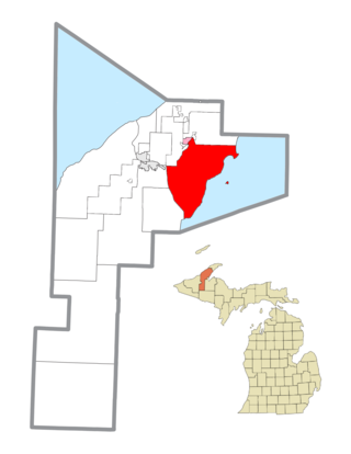
Grant Township is a civil township of Keweenaw County in the U.S. state of Michigan. The population was 275 at the 2020 census. Grant Township is one of the most isolated municipalities in Michigan, as it forms the tip of the Keweenaw Peninsula, which projects into Lake Superior.

Vigor Shipyards is the current entity operating the former Todd Shipyards after its acquisition in 2011. Todd Shipyards was founded in 1916, which owned and operated shipyards on the West Coast of the United States, East Coast of the United States and the Gulf. Todd Shipyards were a major part of the Emergency Shipbuilding Program for World War II.

The South Orkney Islands are a group of islands in the Southern Ocean, about 604 km (375 mi) north-east of the tip of the Antarctic Peninsula and 844 km (524 mi) south-west of South Georgia Island. They have a total area of about 620 km2 (240 sq mi). The islands are claimed both by Britain, and by Argentina as part of Argentine Antarctica. Under the 1959 Antarctic Treaty, sovereignty claims are held in abeyance.

The Republic of Canada was a government proclaimed by William Lyon Mackenzie on December 5, 1837. The self-proclaimed government was established on Navy Island in the Niagara River in the latter days of the Upper Canada Rebellion.

Navy Island is a small, uninhabited island in the Niagara River in the province of Ontario, managed by Parks Canada as a National Historic Site of Canada. It is located about 4.5 kilometres upstream from Horseshoe Falls, and has an area of roughly 1.2 km2. It is across from the town of Grand Island, New York, US. It was designated a national historic site in 1921 in recognition of its role in shipbuilding and the location of the short-lived Republic of Canada. The island is the only island in the Niagara River located within Canadian territory and is the second largest Island in the Niagara River. The site is closed to the public, has no visitor facilities, and has not allowed camping since the expiration of a lease with the Niagara Parks Commission.

The United States Exploring Expedition of 1838–1842 was an exploring and surveying expedition of the Pacific Ocean and surrounding lands conducted by the United States. The original appointed commanding officer was Commodore Thomas ap Catesby Jones. Funding for the original expedition was requested by President John Quincy Adams in 1828; however, Congress would not implement funding until eight years later. In May 1836, the oceanic exploration voyage was finally authorized by Congress and created by President Andrew Jackson.

South Bass Island is a small island in western Lake Erie, and a part of Ottawa County, Ohio, United States. It is the southernmost of the three Bass Islands and located 3 miles (4.6 km) from the south shore of Lake Erie. It is the third largest island in the Lake Erie Islands, and is part of Put-in-Bay Township. In the bay of South Bass is Gibraltar Island, home to the Ohio State University's Stone Laboratory.
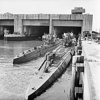
A submarine pen is a type of submarine base that acts as a bunker to protect submarines from air attack.

Ernst Jakob Henne was a German motorcycle racer and racecar driver.

Rich Passage is a tidal strait in Puget Sound, allowing access to Bremerton, Washington, the Puget Sound Naval Shipyard, Sinclair Inlet, and Dyes Inlet. It separates Bainbridge Island from the Manchester area of Kitsap Peninsula. The Seattle–Bremerton ferry, part of the Washington State Ferries, travels the length of Rich Passage on its route.

The borders of the oceans are the limits of Earth's oceanic waters. The definition and number of oceans can vary depending on the adopted criteria. The principal divisions of the five oceans are the Pacific Ocean, Atlantic Ocean, Indian Ocean, Southern (Antarctic) Ocean, and Arctic Ocean. Smaller regions of the oceans are called seas, gulfs, bays, straits, and other terms. Geologically, an ocean is an area of oceanic crust covered by water.
Ketron Island is an island and a census-designated place (CDP) in Pierce County, Washington, United States. The island had a population of 24 persons according to the 2000 census, and 17 persons at the 2010 census.

Pee Pee Island is a small island located in the province of Newfoundland and Labrador in the far east of Canada. It is the smallest of the four islands in the Witless Bay Ecological Reserve, which it became a part of in 1983. It serves as a breeding place for Atlantic puffins.
References
- ↑ "The Phantom Isles of the Pacific". New York Times. May 15, 1904. p. 11.
- ↑ Various; Authors, Various (1838). The Nautical Magazine and Naval Chronicle for 1838. Cambridge University Press. p. 366. ISBN 9781108053945.
| | This article about a specific oceanic location or ocean current is a stub. You can help Wikipedia by expanding it. |