
Rajasthan is a state in northern India. The state covers an area of 342,239 square kilometres (132,139 sq mi) or 10.4 percent of the total geographical area of India. It is the largest Indian state by area and the seventh largest by population. Rajasthan is located on the northwestern side of India, where it comprises most of the wide and inhospitable Thar Desert and shares a border with the Pakistani provinces of Punjab to the northwest and Sindh to the west, along the Sutlej-Indus river valley. Elsewhere it is bordered by five other Indian states: Punjab to the north; Haryana and Uttar Pradesh to the northeast; Madhya Pradesh to the southeast; and Gujarat to the southwest.

The Thar Desert, also known as the Great Indian Desert, is a large arid region in the northwestern part of the Indian subcontinent that covers an area of 200,000 km2 (77,000 sq mi) and forms a natural boundary between India and Pakistan. It is the world's 17th largest desert, and the world's 9th largest subtropical desert.

The Permian Basin is a large sedimentary basin in the southwestern part of the United States. The basin contains the Mid-Continent Oil Field province. This sedimentary basin is located in western Texas and southeastern New Mexico. It reaches from just south of Lubbock, past Midland and Odessa, south nearly to the Rio Grande River in southern West Central Texas, and extending westward into the southeastern part of New Mexico. It is so named because it has one of the world's thickest deposits of rocks from the Permian geologic period. The greater Permian Basin comprises several component basins; of these, the Midland Basin is the largest, Delaware Basin is the second largest, and Marfa Basin is the smallest. The Permian Basin covers more than 86,000 square miles (220,000 km2), and extends across an area approximately 250 miles (400 km) wide and 300 miles (480 km) long.

The Niger Delta Basin, also referred to as the Niger Delta province, is an extensional rift basin located in the Niger Delta and the Gulf of Guinea on the passive continental margin near the western coast of Nigeria with suspected or proven access to Cameroon, Equatorial Guinea and São Tomé and Príncipe. This basin is very complex, and it carries high economic value as it contains a very productive petroleum system. The Niger delta basin is one of the largest subaerial basins in Africa. It has a subaerial area of about 75,000 km2, a total area of 300,000 km2, and a sediment fill of 500,000 km3. The sediment fill has a depth between 9–12 km. It is composed of several different geologic formations that indicate how this basin could have formed, as well as the regional and large scale tectonics of the area. The Niger Delta Basin is an extensional basin surrounded by many other basins in the area that all formed from similar processes. The Niger Delta Basin lies in the south westernmost part of a larger tectonic structure, the Benue Trough. The other side of the basin is bounded by the Cameroon Volcanic Line and the transform passive continental margin.
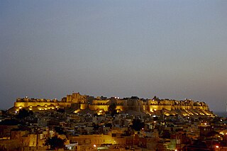
Jaisalmerpronunciation (help·info), nicknamed "The Golden city", is a city in the Indian state of Rajasthan, located 575 kilometres (357 mi) west of the state capital Jaipur. Once known as Jaisalmer state it is a World Heritage Site. The town stands on a ridge of yellowish sandstone, and is crowned by the ancient Jaisalmer Fort. This fort contains a royal palace and several ornate Jain temples. Many of the houses and temples of both the fort, and of the town below, are built of finely sculptured sandstone. The town lies in the heart of the Thar Desert and has a total population, including the residents of the fort, of about 78,000. It is the administrative headquarters of Jaisalmer District.

Barmer District is a district in Rajasthan state of India. It is located in the western part of Rajasthan state forming a part of the Thar Desert. Barmer is the third largest district by area in Rajasthan and fifth largest district in India. Occupying an area of 28,387 km2. Being in the western part of the state, it includes a part of the Thar Desert. Jaisalmer is to the north of this district while Jalore is in its south. Pali and Jodhpur form its eastern border and it shares a border with Pakistan in the west. Partially being a desert, this district has a large variation in temperature. The temperature in summer can rise up to 51 °C and falls near to 0 °C in winter. Luni is the longest river in Barmer district. After travelling a length of almost 500 km, it passes through Jalore and merges in the marshy land of Runn of Kutch. District headquarters is in the town of Barmer. The other major towns in the district are: Balotra, Guda Malani, Baytoo, Siwana, and Chohatan. Recently, a large onshore oil field has been discovered and made functional in Barmer district.

Jaisalmer Fort is situated in the city of Jaisalmer, in the Indian state of Rajasthan. It is believed to be one of the very few "living forts" in the world, as nearly one fourth of the old city's population still resides within the fort. For the better part of its 800-year history, the fort was the city of Jaisalmer. The first settlements outside the fort walls, to accommodate the growing population of Jaisalmer, are said to have come up in the 17th century.

The San Juan Basin is a geologic structural basin located near the Four Corners region of the Southwestern United States. The basin covers 7,500 square miles and resides in northwestern New Mexico, southwestern Colorado, and parts of Utah and Arizona. Specifically, the basin occupies space in the San Juan, Rio Arriba, Sandoval, and McKinley counties in New Mexico, and La Plata and Archuleta counties in Colorado. The basin extends roughly 100 miles N-S and 90 miles E-W.

The Piceance Basin is a geologic structural basin in northwestern Colorado, in the United States. It includes geologic formations from Cambrian to Holocene in age, but the thickest section is made up of rocks from the Cretaceous Period. The basin contains reserves of coal, natural gas, and oil shale. The name likely derives from the Shoshoni word /piasonittsi/ meaning “tall grass”.
In petroleum geology, source rock refers to rocks from which hydrocarbons have been generated or are capable of being generated. They form one of the necessary elements of a working petroleum system. They are organic-rich sediments that may have been deposited in a variety of environments including deep water marine, lacustrine and deltaic. Oil shale can be regarded as an organic-rich but immature source rock from which little or no oil has been generated and expelled. Subsurface source rock mapping methodologies make it possible to identify likely zones of petroleum occurrence in sedimentary basins as well as shale gas plays.

The Cardium Formation is a stratigraphic unit of Late Cretaceous age in the Western Canada Sedimentary Basin. It takes the name from the fossilized Cockle (Cardiidae) shells that it contains, and it was first described along the Bow River banks by James Hector in 1895. It is present throughout western Alberta and in northeastern British Columbia, and it is a major source of petroleum and natural gas.
The New Albany Shale is an organic-rich geologic formation of Devonian and Mississippian age in the Illinois Basin of the United States. It is a major source of hydrocarbons.
The Rajasthan Basin is a sedimentary basin located in the north west part of India. This sedimentary basin is one of India’s major sources of petroleum and natural gas and has a geographical extent of about 126,000 square kilometres (49,000 sq mi). The Rajasthan Basin unconfirmably lies over a pre-Cambrian basement..
Lanela is a village located in the district of Jaisalmer in the state of Rajasthan in India. It has a population of about 1049 persons living in around 194 households.

The West Siberian petroleum basin is the largest hydrocarbon basin in the world covering an area of about 2.2 million km2.

The Persian Gulf Basin, is found between the Eurasian and the Arabian Plates. The Persian Gulf is described as a shallow marginal sea of the Indian Ocean that is located between the south western side of Iran and the Arabian Peninsula and south and southeastern side of Oman and the United Arab Emirates. Other countries that border the Persian Gulf basin include; Saudi Arabia, Qatar, Kuwait, Bahrain and Iraq. The Gulf extends a distance of 1000 km with an area of 240,000 square km. The Persian Gulf basin is a wedge-shaped foreland basin which lies beneath the western Zagros thrust and was created as a result of the collision between the Arabian and Eurasian plates.

The offshore Indus Basin is one of the two basins in offshore Pakistan, the other one being the offshore Makran Basin. The Murray Ridge separates the two basins. The offshore Indus basin is approximately 120 to 140 kilometers wide and has an areal extent of ~20,000 square km.

The Delta Field is located offshore from Nigeria on Oil Mining Leases (OML) 49 and 95. This is located within the Niger Delta Basin and sits in 12 feet of water. In 1965, the Delta 1 well was completed and the Delta Field opened in 1968 for production.
The geology of Nigeria formed beginning in the Archean and Proterozoic eons of the Precambrian. The country forms the Nigerian Province and more than half of its surface is igneous and metamorphic crystalline basement rock from the Precambrian. Between 2.9 billion and 500 million years ago, Nigeria was affected by three major orogeny mountain-building events and related igneous intrusions. Following the Pan-African orogeny, in the Cambrian at the time that multi-cellular life proliferated, Nigeria began to experience regional sedimentation and witnessed new igneous intrusions. By the Cretaceous period of the late Mesozoic, massive sedimentation was underway in different basins, due to a large marine transgression. By the Eocene, in the Cenozoic, the region returned to terrestrial conditions.
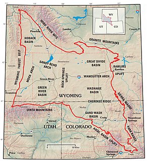
The Greater Green River Basin (GGRB) is a 21,000 square mile basin located in Southwestern Wyoming. The Basin was formed during the Cretaceous period sourced by underlying Permian and Cretaceous deposits. The GGRB is host to many anticlines created during the Laramide Orogeny trapping many of its hydrocarbon resources. It is bounded by the Rawlins Uplift, Uinta Mountains, Sevier overthrust belt, Sieria Madre Mountains, and the Wind River Mountain Range. The Greater Green River Basin is subdivided into four smaller basins the Green River Basin, Great Divide Basin, Washakie Basin, and Sand Wash Basin. Each of which possesses hydrocarbons that have been economically exploited. There are 303 named fields throughout the basin the majority of which produce natural gas, the largest of these gas fields is the Jonah Field.


