
Māʻili is a census-designated place (CDP) in the Waiʻanae District on the island of Oʻahu, City & County of Honolulu, Hawaiʻi, United States. In Hawaiian, māʻili means "pebbly", referring to rounded stones at the shore. Māʻili is located along Farrington Highway on Oʻahu's Leeward Coast, between Māʻili Beach Park to the west and Lualualei Valley to the east. It is located 1.4 miles south of the town of Waianae, separated by the Māʻiliʻili Stream, and 1.5 miles north of Nanakuli. As of the 2020 census, the town population was 11,535. Māʻili has one 7-Eleven, a gas station, and a few residential developments. The town is also home to several dairy farms and vegetable plots. Two tall, red antennae near the mouth of the Lualualei Valley are parts of the Navcom Radio Transmitting Facility, and were the tallest man-made structures in the Western Hemisphere at 1,503 feet when they were built in 1972. The town has an elevation of 20 feet (6.1 m).

Makapuʻu is the extreme eastern end of the Island of Oʻahu in the Hawaiian Islands, comprising the remnant of a ridge that rises 647 feet (197 m) above the sea. The cliff at Makapuʻu Point forms the eastern tip and is the site of a prominent lighthouse. The place name of this area, meaning "bulging eye" in Hawaiian, is thought to derive from the name of an image said to have been located in a cave here called Keanaokeakuapōloli. The entire area is quite scenic and a panoramic view is presented at the lookout on Kalanianaole Highway where the roadway surmounts the cliff just before turning south towards leeward Oʻahu and Honolulu.
Jonah Kūhiō Kalanianaʻole was a prince of the Kingdom of Hawaiʻi until it was overthrown by a coalition of American and European businessmen in 1893. He later went on to become a representative in the Territory of Hawaii as delegate to the United States Congress, and as such is the only royal-born member of Congress.

James Kimo Kealoha was an American politician who served as the first lieutenant governor of Hawaii in the administration of Governor of Hawaiʻi William F. Quinn. Prior to his election as Lieutenant Governor, Kealoha served a number of years as a legislator on Hawaii island, distinguishing himself as a respected leader.

Punaluʻu Beach is a beach between Pāhala and Nāʻālehu on the Big Island of the U.S. state of Hawaii. The beach has black sand made of basalt and created by lava flowing into the ocean which explodes as it reaches the ocean and cools. This volcanic activity is in the Hawaiʻi Volcanoes National Park. Punaluʻu is frequented by endangered hawksbill and green turtles, which can often be seen basking on the black sand.

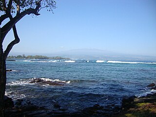
Kealakekua Bay is located on the Kona coast of the island of Hawaiʻi about 12 miles (19 km) south of Kailua-Kona. Settled over a thousand years ago, the surrounding area contains many archeological and historical sites such as religious temples (heiaus) and also includes the spot where the first documented European to reach the Hawaiian islands, Captain James Cook, was killed. It was listed in the National Register of Historic Places listings on the island of Hawaii in 1973 as the Kealakekua Bay Historical District. The bay is a marine life conservation district, a popular destination for kayaking, scuba diving, and snorkeling.

Hāpuna Beach State Recreation Area is a large park and sandy beach on the Big Island of Hawaii. The Hapuna Beach Prince Hotel is also located adjacent to the beach. Hāpuna is popular with residents and visitors.

Hāʻena State Park is a state park on the north shore of the Hawaiian island of Kauaʻi. It is often called the "end of the road" and marks the endpoint of the Kuhio Highway. The park provides access to beaches, trails, and several ancient Hawaiian sites, including sea caves estimated to be more than 4,000 years old. Archaeological sites associated with the hula, including a heiau (shrine) dedicated to Laka, are above the park's beaches.

Papakōlea Beach is a green sand beach located near South Point, in the Kaʻū district of the island of Hawaiʻi. It is one of only four green sand beaches in the world, the others being Talofofo Beach, Guam; Punta Cormorant on Floreana Island in the Galapagos Islands; and Hornindalsvatnet, Norway. It gets its distinctive coloring from olivine sand eroded out of the enclosing volcanic cone.
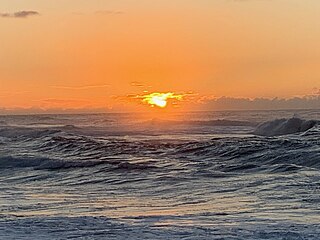
Sunset Beach is on the North Shore of Oahu in Hawaii and known for big wave surfing during the winter season. The original Hawaiian name for this place is Paumalū. It is a two-mile stretch of mostly beige sand located at 59-104 Kamehameha Highway in Pupukea, 39 miles driving distance from Waikiki. Lifeguards are usually present.

Polihale State Park is a remote wild beach on the western side of the Hawaiian island of Kauai. It is the most western publicly accessible area in Hawaii, although the privately owned island of Niihau is farther west. The park is miles away from the town of Kekaha, and it can only be reached via a poorly marked, dirt sugarcane road, making a four-wheel drive vehicle preferable. The beach is several miles long, yet only the area known as "Queen's Pond" offers safe swimming.
The Hawaiʻi Belt Road is a modern name for the Māmalahoa Highway and consists of Hawaiʻi state Routes 11, 19, and 190 that encircle the Island of Hawaiʻi. The southern section, between Hilo and Kailua-Kona is numbered as Route 11. The section between Hilo and Waimea is Route 19. Between Waimea and Kailua-Kona, the road is split in two: the original "mauka" route and a "makai" Route 19, completed in 1975, which serves as access to the Kona and Kohala Coast resorts. In the Hawaiian language, mauka means "towards the mountain" and makai means "towards the sea". These terms are commonly used in travel directions.

Samuel Mahuka Spencer was a Hawaiʻi island politician.

Liliʻuokalani Park and Gardens is a 24.14-acre (97,700 m2) park with Japanese gardens, located on Banyan Drive in Hilo on the island of Hawaiʻi.
Richardson Beach is a Hawaii County park located just east of Hilo, Hawaii, on the Big Island of Hawaii. Adjacent is the Lele'iwi Beach Park.

Old Kona Airport State Recreation Area is a park built on the site of an old landing strip just north of Kailua, Hawaii County, Hawaii.

Māhukona is a former settlement on the island of Hawaiʻi. The extinct submerged volcano Māhukona, off shore and to the south, is named for this area. The settlement was once the terminus of the Hawaiian Railroad.

The Royal Coconut Coast is the designation given to Kauai’s east side, defined as the area between the Wailua Golf Course, heading north along the coast to Kealia Beach, and extending inland toward the center of the island, to Mount Waialeale. The Royal Coconut Coast includes the sacred Wailua River area and the large towns of Wailua and Kapaa. The area's name derives from the acres of coconut trees along the coast and highway. It also has many places of historical and cultural significance. Some of the land is held as sacred and was once reserved for the royalty of Hawaii.

Waiākea-Uka (IPA:/'waj.ə.kei.ə.'u.kə/) is an ancient subdivision (ahupuaʻa) in the Hilo District of the Big Island of Hawaiʻi, located mauka (mountain-side) of the Waiākea ahupua'a; its location is on the lower flanks of the volcano Mauna Loa. Because of this, one meaning of the name 'Waiākea-Uka' can be translated from 'Olelo Hawai'i as '(the) mountain-side (of) Waiākea'. Many ahupua'a have this -uka appellation, as the directions 'mountain-side' and 'sea-side' (makai) are the two best ways of orientating something in space on any of the islands.

William Justin Mullahey was an American airline executive who was a long-time employee of Pan American Airways, helping the company expand its presence across the Pacific. He also played a large role in developing tourism throughout the Pacific Islands, including leading the development of the Pacific Asia Travel Association.


