
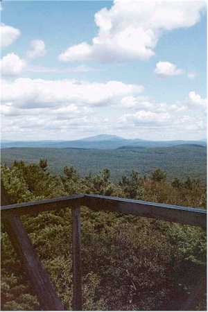
Mount Adams is a 3,520-foot-tall (1,070 m) mountain located in Essex County of New York. Atop the mountain is the Mount Adams Fire Observation Station, added to the National Register of Historic Places in 2006.
Mount Grace State Forest is a publicly owned forest with recreational features located in the town of Warwick. The state forest centers around Mount Grace, which at 1,621 feet (494 m) is the third highest point in Massachusetts east of the Connecticut River after Mount Wachusett and Mount Watatic. It is bordered by portions of Warwick State Forest to the east and west and is managed by the Massachusetts Department of Conservation and Recreation.

The Watchman Lookout Station No. 168 is one of two fire lookout towers in Crater Lake National Park in southern Oregon. For many years, National Park Service personnel used the lookout to watch for wildfires during the summer months. It is also a common hiking destination because of its views of Crater Lake and the surrounding area. The building is unusual because it serves the dual purpose of fire lookout and museum. The Watchman Lookout Station is listed on the National Register of Historic Places.

Harney National Forest was established by the U.S. Forest Service in South Dakota and Wyoming on July 1, 1911, with 642,550 acres (2,600.3 km2) from part of Black Hills National Forest and other lands. On July 1, 1954, the entire forest was added to Black Hills and the name was discontinued.

Blue Mountain is a peak in the Adirondack Mountains of New York State in the United States. Located east of Blue Mountain Lake, Hamilton County, the peak reaches a height of 3,750 ft (1,140 m). For hiking, the elevation gain is 1,559 feet and the trail length is four miles. The trailhead elevation is 2,200 feet. It is the location of the Blue Mountain Fire Observation Station, listed on the National Register of Historic Places in 2001.
Azure Mountain is a 2,323-foot-tall (708 m) mountain near Blue Mountain Road in the Adirondack Park town of Waverly in Franklin County, New York. Azure Mountain is the site of the Azure Mountain Fire Observation Station, a 35-foot-tall (11 m) steel tower that was built in 1918 and later restored in 2002. The fire tower was listed on the National Register of Historic Places in 2001.
The Huckleberry Mountain Fire Overlook is a fire lookout station in northern Bridger–Teton National Forest. The rustic two-story log structure was built in 1938 by the Civilian Conservation Corps to a standard U.S. Forest Service design. The lookout was used for fire surveillance until 1957.
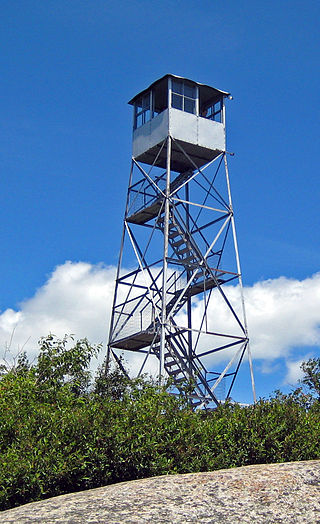
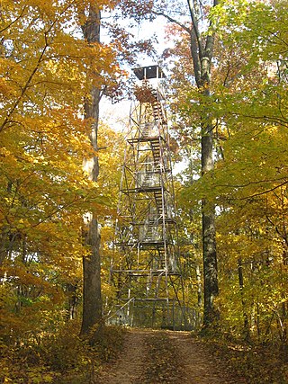
The Poke-O-Moonshine Mountain Fire Observation Station is a historic fire lookout tower on Poke-O-Moonshine Mountain at Chesterfield in Essex County, New York. The station and contributing resources include a 40-foot-tall (12 m), steel-frame lookout tower erected in 1917, a jeep trail that extends from the base of the mountain to a point below its summit, the remains of an observer's cabin possibly built by the Civilian Conservation Corps in 1936, and a spring house. The tower is a prefabricated structure built by the Aermotor Windmill Company.
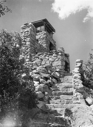
Monjeau Lookout was completed in 1940 by the Civilian Conservation Corps to serve as a fire lookout tower within Lincoln National Forest, New Mexico, United States, and remains in active use as a destination for forest visitors. The structure is a 14-by-14-foot native stone tower which contains living quarters, and is topped with a 7 ft × 7 ft metal-frame cab.

The Unity Ranger Station is a United States Forest Service compound consisting of five buildings and a lookout tower in the Wallowa-Whitman National Forest of northeastern Oregon. It was previously the administrative headquarters for the Unity Ranger District. It is located in the small unincorporated community of Unity, Oregon. The historic structures were built in the rustic style by the Civilian Conservation Corps between 1936 and 1938. Today, the ranger station is only used during the summer months to house Forest Service fire crews. The ranger station is listed on the National Register of Historic Places.
Union Lookout is a lookout tower located within Trail of Tears State Forest in Union County, Illinois, United States. The Civilian Conservation Corps built the tower circa 1934 as part of a network of fire lookout towers in Shawnee National Forest; the fire towers were one of many CCC conservation projects in the forest, which also included planting trees, constructing bridges and trails, and preventing erosion. The tower was used through the 1960s, by which time airplanes had largely replaced towers as a means of detecting fires; it is now the only remaining lookout tower in the forest. On February 5, 2003, Union Lookout was added to the National Register of Historic Places.

The Clay Butte Lookout is a forest fire lookout in Park County, Wyoming. It was listed on the National Register of Historic Places in 2014.

The Bishop Mountain Lookout, located in Island Park, Idaho, was created between 1936 and 1938 by the Civilian Conservation Corps (CCC) in the Caribou-Targhee National Forest. It was listed on the National Register of Historic Places in 1986, and its cabin is currently available as reserved accommodations through the United States Forest Service.
Page Pond Hill is a mountain in the Southern Tier of New York. It is located north-northwest of Sanford in Broome County. In 1935, a 79-foot-6-inch-tall (24.23 m) steel fire lookout tower was built on the mountain. The tower ceased fire lookout operations at the end of the 1988 fire lookout season, and later closed. The site is on private property and is not open to the public.

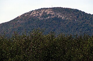
Utsayantha Mountain is a 3,209-foot-tall (978 m) mountain in the Catskill Mountains of New York. It is located east-southeast of Stamford in Delaware County. Variant names include Utsayanthe Mountain, Utsayanthia Mountain, Utsayantho Mountain, and Utsyantha Mountain. McGregor Mountain is located southeast of Utsayantha Mountain and Churchill Mountain is located southwest. Utsayantha Mountain is named after Utsayantha, the daughter of Chief Ubiwacha, chief of the Lenape Indians.
Jackie Jones Mountain is a 1,253-foot-tall (382 m) mountain in the state of New York. It is located west of Stony Point in Rockland County. In 1928, a 60-foot-tall (18 m) steel fire lookout tower was built on the mountain. The tower ceased fire lookout operations at the end of the 1988 fire lookout season, and was officially closed in early 1989. The tower is listed on the National Historic Lookout Register, and is open to the public.
Mount Nimham is a 1,273-foot-tall (388 m) mountain in Hudson Highlands of New York. It is located northwest of Carmel in Putnam County. Nimham Mountain is named after Chief Daniel Nimham of the Wappinger tribe. In 1940, an 82-foot-6-inch-tall (25.15 m) steel fire lookout tower was built on the mountain. The tower ceased fire lookout operations at the end of the 1988 fire lookout season and was officially closed the next year. The tower appears on the National Historic Lookout Register and is still open to the public.

Rock Rift Fire Observation Tower, also known as the Rock Rift Fire Tower, is a historic fire observation station located in the Town of Tompkins, Delaware County, New York. The tower stands at the summit of Tower Mountain at an elevation of 2,376 ft (724 m) and rises above the Cannonsville Reservoir, part of New York City’s extensive water supply system. It was built in 1934 and listed on the National Register of Historic Places # 100003231 in 2018. The Rock Rift Fire Tower is also listed on the National Historic Lookout Register of the Forest Fire Lookout Association. Its listing numbers are US 1183, NY 41. The tower was transferred to the Town of Tompkins from New York State Department of Environmental Conservation in 2017. The land that the tower rests on is owned by New York City as part of their West of Hudson Watershed. The tower was decommissioned from active use in 1989.

Goodnow Mountain is a 2,664-foot-tall (812 m) peak in the Adirondack Mountains of New York in the United States. It is the location of the Goodnow Mountain Fire Observation Station. In 1922, the Civilian Conservation Corps built a 60-foot-tall fire tower on the mountain. The tower closed at the end of the 1979 season. The tower was later transferred to SUNY College of Forestry and is now open to the public.
Berry Hill is a 1,962-foot-tall (598 m) mountain in the Central New York region of New York. It is located west-northwest of Norwich in Chenango County. The Berry Hill Fire Observation Station is located on top of the mountain. The fire tower was built by the Civilian Conservation Corps in 1934. The tower ceased operation in 1988 and was officially closed early in 1989. In 1993, the tower was placed on the National Historic Lookout Register. The tower was refurbished and opened to the public on September 13, 2021.


