
Bolinas Bay is a small bay, approximately 5 miles (8 km) wide, on the Pacific coast of California in the United States. It is in Marin County, north of the Golden Gate, approximately 15 miles (25 km) northwest of San Francisco. The town of Bolinas is at its shore.

Bolinas Lagoon is a tidal estuary, approximately 1,100 acres (4.5 km2) in area, located in the West Marin region of Marin County, California, United States, adjacent to the town of Bolinas. It is a part of the Greater Farallones National Marine Sanctuary and is considered to be among the possible landing spots of Sir Francis Drake on the west coast of North America in 1579.

Mount Eden was an unincorporated agricultural district in Eden Township, Alameda County, California, United States of America. It was annexed by the City of Hayward. It lies at an elevation of 43 feet.
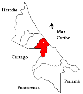
Matina is the fifth canton in the province of Limón in Costa Rica. The canton covers an area of 576.48 km², and has a population of 37,549. Its capital city is also called Matina.

Año Nuevo State Marine Conservation Area (SMCA) is one of two adjoining marine protected areas off the coast of San Mateo and Santa Cruz Counties, on California’s central coast.The area is approximately 55 miles south of San Francisco. The SMCA is 11.07 square miles. Except for limited taking of giant kelp, all living marine resources are protected.
Hopewell is a former community in Pike County, Arkansas, United States. It lay at an elevation of 423 feet.

Merrills Landing is an unincorporated community in Butte County, California, on the Sacramento River. It lies at an elevation of 177 feet.
Mowry Landing is an unincorporated community in Alameda County, California. It is located 2 miles (3.2 km) southeast of Newark. It lies at an elevation of 10 feet.
Mulford Gardens is a neighborhood in San Leandro in Alameda County, California. It lies at an elevation of 20 feet. It was formerly an unincorporated community. It is between Mulford and Mulford Landing.
Larkin's Landing is a former settlement in Alameda County, California. It is located along Mowry Slough east of Mowry Landing. The name is in honor of Stephen Larkin, a farmer from Nova Scotia, who settled here in 1851.
Eden Landing is a former settlement in Alameda County, California. Eden Landing was located west-southwest of Mount Eden. Its site is now located within the corporate limits of Hayward. Eden Landing was established in 1854 by farmers who were dissatisfied with the freight charges at Allen's Landing, which was a quarter of a mile west. The place was bought by Richard Barron in 1855, and renamed Barrons Landing. Henry Louis Petermann and Mary F. Petermann operated their salt works here. Stokes Landing was located east of Eden Landing on Alameda Creek.
Stokes Landing is a ghost town in Alameda County, California, United States. Stokes Landing was located along Alameda Creek east of Eden Landing. The name is in honor of James Johnstone Stokes, who founded the place in 1858. Today the area lies within the city of Hayward, California.
Duxbury Reef State Marine Conservation Area (SMCA) is a marine protected area located about 1 mile (2 km) west of Bolinas in Marin County on California’s north central coast. This marine protected area covers 0.66 square miles (1.7 km2). Duxbury Reef SMCA prohibits the take of all living marine resources, except the recreational take of finfish from shore only and the recreational take of abalone.

Montara State Marine Reserve (SMR) and Pillar Point State Marine Conservation Area (SMCA) are two adjoining marine protected areas that extend offshore from Montara to Pillar Point in San Mateo County on California’s north central coast. The combined area of these marine protected areas is 18.42 square miles (47.7 km2), with 11.76 square miles (30.5 km2) in the SMR and 6.66 in the SMCA. Montara SMR prohibits the take of all living marine resources. Pillar Point SMCA prohibits the take of all living marine resources, except the recreational and commercial take of pelagic finfish by trolling or seine, the commercial or recreational take of Dungeness crab by trap and the commercial or recreational take or market squid by hand-held dip net or round haul net.
Greyhound Rock State Marine Conservation Area (SMCA) is one of two adjoining marine protected areas off the coast of San Mateo County and Santa Cruz County, on California’s central coast. The area is approximately 55 miles (89 km) south of San Francisco. The SMCA is 11.81 square miles (30.6 km2). Within the SMCA fishing and take of all living marine resources is prohibited except the recreational take of giant kelp, squid, salmon, and other finfish, subject to various conditions. Also permitted is the commercial take of giant kelp, salmon, and squid, subject to various conditions.
Rancho Ex-Mission San José was a 30,000-acre (120 km2) Mexican land grant in present-day Alameda County, California given in 1846 by Governor Pio Pico to Andrés Pico and Juan B. Alvarado. The grant derives its name from the secularized Mission San José, and was called ex-Mission because of a division made of the lands held in the name of the Mission—the church retaining the grounds immediately around, and all of the lands outside of this are called ex-Mission lands. The grant extended to the lands of present-day Fremont including the former towns, now districts of Centerville, Irvington and Mission San Jose.
Union Landing Shopping Center is an open-air shopping mall in the 100-acre redevelopment Dyer Triangle in Union City, California, adjacent to Interstate 880, between Alvarado-Niles Road and Dyer Street and the largest shopping center in the city. The majority of this area was occupied by Union City Drive-In Theater between 1966 and 1998. The Center has two large Pylon signs near 880 and is in the process in the future to be rebranded by City Of Union City.
Sir Francis Drake's landing on the west coast of North America in 1579 has drawn the attention of scores of historians, geographers, linguists, anthropologists and other professionals. In addition, many history buffs have sought to locate Drake's New Albion. More than a score of ideas have been put forth—covering the coast from Alaska to Southern California. These ideas span the eighteenth through the early twenty-first centuries.
Tuckahoe is an unincorporated community in Jasper County, in the U.S. state of Missouri.
Walnut Creek is a stream in Polk County the Ozarks of southwest Missouri. It is a tributary of the Little Sac River.


