
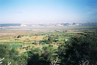
Saguia el-Hamra was, with Río de Oro, one of the two territories that formed the Spanish province of Spanish Sahara after 1969. Its name comes from a waterway that goes through the capital. The wadi is inhabited by the Oulad Tidrarin Sahrawi tribe.
The Bou Regreg is a river located in western Morocco which discharges to the Atlantic Ocean between the cities of Rabat and Salé. The estuary of this river is termed Wadi Sala.

High Atlas, also called the Grand Atlas Mountains is a mountain range in central Morocco, North Africa.

The Moulouya River is a 520 kilometers long river in Morocco. Its sources are located in the Ayashi mountain in the Middle Atlas. It empties into the Mediterranean Sea near Saïdia, in northeast Morocco at about 35.1228°N 2.3367°W.

The Al Hamra Tower is a skyscraper in Kuwait City, Kuwait. It is the tallest building in Kuwait.
Gzennya or Igzennayen is the name of many Berber tribes and places in the mountainous Rif region in northern Morocco.

The Arraya Tower is a skyscraper completed in 2009 in Kuwait City, Kuwait. The tower serves as a grade-A office structure. With sixty storeys, and 300 metres high, the building was the tallest tower in Kuwait until the construction of Al Hamra Tower in 2011. On January 19, 2010, The Council on Tall Buildings and Urban Habitat (CTBUH) announced that Arraya Tower was the 4th-tallest building completed in 2009.

The Anti-Atlas, Lesser Atlas or Little Atlas is a mountain range in Morocco, a part of the Atlas Mountains in the northwest of Africa. The Anti-Atlas extends from the Atlantic Ocean in the southwest toward the northeast, to the heights of Ouarzazate and further east to the city of Tafilalt, altogether a distance of approximately 500 km. The range borders on the Sahara to the south.

The Middle Atlas is a mountain range in Morocco. It is part of the Atlas mountain range, a vast mountainous region with more than 100,000 km2, 15 percent of its landmass, rising above 2,000 metres. The Middle Atlas is the northernmost and second highest of three main Atlas Mountains chains of Morocco. To south, separated by the Moulouya and Um Er-Rbiâ rivers, lies the High Atlas. The Middle Atlas form the westernmost end of a large plateaued basin extending eastward into Algeria, also bounded by the Tell Atlas to the north and the Saharan Atlas to the south, both lying largely in Algeria. North of the Middle Atlas and separated by the Sebou River, lie the Rif mountains which are an extension of the Baetic System, which includes the Sierra Nevada in the south of Spain. The basin of the Sebou is not only the primary transportation route between Atlantic Morocco and Mediterranean Morocco but is an area, watered by the Middle Atlas range, that constitutes the principal agricultural region of the country.
Jbel Ayachi is one of the highest mountains in North Africa, and anchors the Eastern High Atlas in central Morocco. Jbel Ayachi rises to a height of 3,757 m above sea level.
Boujdour is a province in the Moroccan economic region of Laâyoune-Sakia El Hamra. Its population in 2004 was 46,129. Its major town is Boujdour.

Laâyoune is a delineated province in the north-west of Moroccan economic region of Laâyoune-Sakia El Hamra, which is situated within the northern part of the disputed territory of Western Sahara. Its population in 2004 was 210,023. In today's limits of the province the population was 199,603. Its main town is Laayoune.

Al-Hamra, was a Palestinian Arab village in the District of Baysan. It was located 7.5 kilometres south of Baysan. It was depopulated by the Israeli Army during the 1948 Arab-Israeli War. The village was named after the Bedouin tribe who settled in the village lands centuries ago. The population in 1945 was 730, expanding to 847 in 1948.
Al-Hamra' was a Palestinian Arab village in the Safad Subdistrict. It was depopulated during the 1947–1948 Civil War in Mandatory Palestine on May 1, 1948, by the Palmach's First Battalion of Operation Yiftach. It was located 24.5 km northeast of Safad, 1 km northwest of Wadi al-Dufayla.

Tighassaline is a town in Khénifra Province, Béni Mellal-Khénifra, Morocco. According to the 2004 census it has a population of 7336.
Boumalne Dades is a town in Tinghir Province, Drâa-Tafilalet, Morocco. According to the 2014 census, it had a population of 12,328.

The Jbel Saghro or Djebel Sahrho is a mountain range in southern Morocco. It is located south of the High Atlas and east of the Anti-Atlas in the northwest of Africa, northeast of Taliouine and southwest of Ouarzazate.

Tarfaya is a province in the Moroccan economic region of Laâyoune-Sakia El Hamra, which includes the southwestern part of the territory of Morocco as of before 1975, and the northern part of the disputed territory of Western Sahara. Its population in 2004 was 10420. Its main town is Tarfaya.

Mount Kissane(Jbel Kissane) is a mountain in southeastern Morocco, in the region of Drâa-Tafilalet. It is a distinctive mountain located in the Anti-Atlas range along the valley of the Draa River.


