Homewood is a city in southeastern Jefferson County, Alabama, United States. It is a suburb of Birmingham, located on the other side of Red Mountain due south of the city center. The population was 26,414 at the 2020 census.

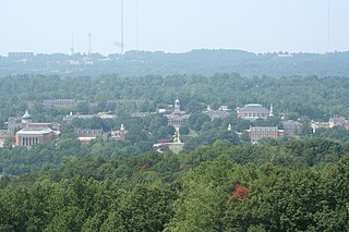
Augusta, officially the City of Augusta, is a city on the central eastern border of the U.S. state of Georgia. The city lies directly across the Savannah River from North Augusta, South Carolina at the head of its navigable portion. Augusta, the third most populous city in Georgia, is situated in the Fall Line region of the state.
The Greater Richmond, Virginia area has many neighborhoods and districts.
Jefferson Avenue is a 63.71-mile-long (102.53 km) scenic road along the eastern part of the Detroit metropolitan area in the southeastern part of the U.S. state of Michigan. It travels alongside Lake Erie, the Detroit River, and Lake St. Clair. This road also provides access to many recreational facilities in the area. West Jefferson Avenue is primarily commercial, while East Jefferson Avenue contains a historic residential district.
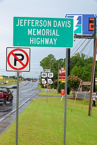
The Jefferson Davis Highway, also known as the Jefferson Davis Memorial Highway, was a transcontinental highway in the United States in the 1910s and 1920s that began in Arlington County, Virginia, and extended south and west to San Diego, California; it was named for Jefferson Davis, President of the Confederate States, United States senator, and Secretary of War. Because of unintended conflict between the National Auto Trail movement and the federal government, it is unclear whether it ever really existed in the complete form that its United Daughters of the Confederacy (UDC) founders originally intended.

Hurontario Street is a roadway running in Ontario, Canada between Lake Ontario at Mississauga and Lake Huron's Georgian Bay at Collingwood. Within Peel Region, it is a major urban thoroughfare within the cities of Mississauga and Brampton, which serves as the divide from which cross-streets are split into East and West, except at its foot in the historic Mississauga neighbourhood of Port Credit. Farther north, with the exception of the section through Simcoe County, where it forms the 8th Concession, it is the meridian for the rural municipalities it passes through. In Dufferin County, for instance, parallel roads are labelled as EHS or WHS for East of Hurontario Street.

U.S. Highway 1 (US 1) in the U.S. state of Georgia, which is concurrent for almost its entire length with State Route 4 (SR 4), is a highway traversing south–north through portions of Charlton, Ware, Bacon, Appling, Toombs, Emanuel, Jefferson, and Richmond counties in the southeastern and east-central parts of the state. In Georgia, the highway originates at US 1/US 23/US 301/State Road 15 (SR 15) at the St. Marys River and the Florida state line, where SR 4 reach their southern terminus. It travels to the Savannah River at the South Carolina state line in Augusta where the route continues to North Augusta, South Carolina. Here, SR 10 reaches its eastern terminus.

State Route 11 (SR 11) is a 376-mile-long (605 km) state highway in the U.S. state of Georgia, traveling through portions of Echols, Lanier, Berrien, Irwin, Ben Hill, Wilcox, Pulaski, Houston, Peach, Bibb, Jones, Jasper, Newton, Walton, Barrow, Jackson, Hall, White, Lumpkin, and Union counties. It travels the entire length of the state from south to north, connecting the Florida state line with the North Carolina state line, roughly bisecting the state into two equal parts. It travels through Warner Robins, Macon, and Gainesville. It is the longest route in the state. The portion from the southeastern city limits of Monticello to the Jasper–Newton county line is included in the Monticello Crossroads Scenic Byway.

U.S. Route 90 (US 90) in the state of Florida is the northernmost east–west United States Numbered Highway in the state. US 90 not only passes through the county seats of all the 16 counties it runs through on its course in Florida and is also the road upon which many of the county courthouses are located, but it was the first paved road in Florida. It is never more than six miles (9.7 km) from Interstate 10 (I-10) throughout the state. It runs as a two-lane highway through most of the sparsely populated inland areas of the Florida Panhandle, widening to four lanes through and near several towns. The speed limit is 55 mph (89 km/h) for all rural points west of Monticello, and it is 60 mph (97 km/h) on all rural points from where it enters Madison County as far as Glen St. Mary.

U.S. Route 221 (US 221) in Florida is a north–south United States Highway. It runs 40 miles (64 km) from Perry northwest to the Georgia State Line in Taylor, Madison and Jefferson Counties. The entire route is inventoried by FDOT as the northern section of unsigned State Road 55. A short overlap with US 90 exists in Greenville.
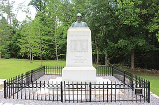
Jefferson Davis Memorial Historic Site is a 12.668-acre (5.127 ha) state historic site located in Irwin County, Georgia that marks the spot where Confederate States President Jefferson Davis was captured by United States Cavalry on Wednesday, May 10, 1865. The historic site features a granite monument with a bronze bust of Davis that is located at the place of capture. The memorial museum, built in 1939 by the Works Progress Administration, features Civil War era weapons, uniforms, artifacts and an exhibit about the president's 1865 flight from Richmond, Virginia to Irwin County, Georgia.

U.S. Route 129 (US 129) is a 375-mile-long (604 km) U.S. Highway in the U.S. state of Georgia. It travels south-to-north from the Florida state line, south of Statenville, to the North Carolina state line, northwest of Blairsville.
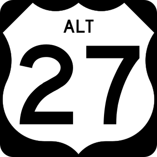
U.S. Highway 27 Alternate is an alternate route of US 27. It travels from the northwestern corner of Columbus northeast to just before Shiloh, north to Greenville, and northwest to Carrollton.

State Route 82 (SR 82) is a 36.1-mile-long (58.1 km) arc-shaped state highway in the Piedmont region in the U.S. state of Georgia. The highway connects Winder to a point east of Gainesville, via Arcade and Jefferson.
Several special routes of U.S. Route 129 exist, most of which are in the state of Georgia.


