Jelinak | |
---|---|
Village | |
Coordinates: 44°09′N17°53′E / 44.150°N 17.883°E | |
Country | |
Entity | Federation of Bosnia and Herzegovina |
Municipality | Busovača |
Time zone | CET (UTC+1) |
• Summer (DST) | CEST (UTC+2) |
Jelinak is a village in the municipality of Busovača, Bosnia and Herzegovina. [1]
A village is a clustered human settlement or community, larger than a hamlet but smaller than a town, with a population ranging from a few hundred to a few thousand. Though villages are often located in rural areas, the term urban village is also applied to certain urban neighborhoods. Villages are normally permanent, with fixed dwellings; however, transient villages can occur. Further, the dwellings of a village are fairly close to one another, not scattered broadly over the landscape, as a dispersed settlement.
In Bosnia and Herzegovina the smallest administrative unit is the municipality. Prior to the 1992–95 Bosnian War there were 109 municipalities in what was then Socialist Republic of Bosnia and Herzegovina. Ten of these formed the area of the capital Sarajevo.
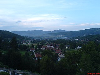
Busovača is a town and municipality located in Central Bosnia Canton of the Federation of Bosnia and Herzegovina, an entity of Bosnia and Herzegovina. It is located 60 km (37 mi) from Sarajevo, 21 km (13 mi) from Zenica, and 30 km (19 mi) from Travnik.
Bosanska Krupa is a town and municipality located in Una-Sana Canton of the Federation of Bosnia and Herzegovina, an entity of Bosnia and Herzegovina. As of 2013, it has a population of 29,659 inhabitants.
Ravno is a village and municipality located in Herzegovina-Neretva Canton of the Federation of Bosnia and Herzegovina, an entity of Bosnia and Herzegovina. Ravno was a separate county until 1963, when it became a part of the Trebinje municipality. In 1994, the border changed and Ravno became a municipality again. This time however, part of the frontier lands of Trebinje municipality were added as part of Ravno. When Ravno inherited part of the former Trebinje municipality it had an area of 447 km2 (173 sq mi). These added borderlands went under the title Travunian Marches and were mostly inhabited by Serbs. The settlement of Ivanica has an unobstructed view of the Adriatic sea.
Ugorsko is a village in Vogošća municipality, near Sarajevo, Federation of Bosnia and Herzegovina, Bosnia and Herzegovina.
Bočac is a village in the municipality of Banja Luka, Republika Srpska, Bosnia and Herzegovina.
Krupa na Vrbasu is a village in the municipality of Banja Luka, Republika Srpska, Bosnia and Herzegovina.
Brekovica is a village in the municipality of Bihać, Bosnia and Herzegovina.
Arapuša is a village in the municipality of Bosanska Krupa, Bosnia and Herzegovina.
Donji Dubovik is a village in the municipality of Krupa na Uni, Bosnia and Herzegovina.
Donji Rahić is a village in the municipality of Brčko, Bosnia and Herzegovina.
Kaonik is a village in the municipality of Busovača, Bosnia and Herzegovina.
Skradno is a village in the municipality of Busovača, Bosnia and Herzegovina.
Majevac is a village in the municipality of Doboj, Bosnia and Herzegovina.
Ostružnja Gornja is a village in the municipality of Stanari, Bosnia and Herzegovina.
Boždarevići is a village in the municipality of Konjic, Bosnia and Herzegovina.
Boljkovići is a village in the municipality of Kiseljak, Bosnia and Herzegovina.
Milačevići is a village in the municipality of Srebrenica, Bosnia and Herzegovina.
Pećišta is a village in the municipality of Srebrenica, Bosnia and Herzegovina.
Čobe is a village in the municipality of Maglaj, Bosnia and Herzegovina.
Vukšić Gornji is a village in the municipality of Brčko, Bosnia and Herzegovina.
Coordinates: 44°09′N17°53′E / 44.150°N 17.883°E
A geographic coordinate system is a coordinate system that enables every location on Earth to be specified by a set of numbers, letters or symbols. The coordinates are often chosen such that one of the numbers represents a vertical position and two or three of the numbers represent a horizontal position; alternatively, a geographic position may be expressed in a combined three-dimensional Cartesian vector. A common choice of coordinates is latitude, longitude and elevation. To specify a location on a plane requires a map projection.
This Central Bosnia Canton geography article is a stub. You can help Wikipedia by expanding it. |