Great Barrier Island lies in the outer Hauraki Gulf, New Zealand, 100 kilometres (62 mi) north-east of central Auckland. With an area of 285 square kilometres (110 sq mi) it is the sixth-largest island of New Zealand and fourth-largest in the main chain. Its highest point, Mount Hobson, is 627 metres (2,057 ft) above sea level. The local authority is the Auckland Council.

Coromandel Town is a town on the Coromandel Harbour, on the western side of the Coromandel, which is in the North Island of New Zealand. It is 75 kilometres east of the city of Auckland, although the road between them, which winds around the Firth of Thames and Hauraki Gulf coasts, is 190 km long. The population was 1,750 as of June 2018.
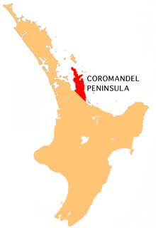
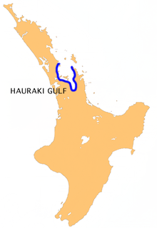
The Coromandel Peninsula on the North Island of New Zealand extends 85 kilometres north from the western end of the Bay of Plenty, forming a natural barrier to protect the Hauraki Gulf and the Firth of Thames in the west from the Pacific Ocean to the east. It is 40 kilometres wide at its broadest point. Almost the entire population lies on the narrow coastal strips fronting the Hauraki Gulf and the Bay of Plenty. In clear weather the peninsula is clearly visible from Auckland, the country's biggest city, which lies on the far shore of the Hauraki Gulf, 55 kilometres to the west. The peninsula is part of the Thames-Coromandel District of the Waikato Region.

Cape Colville is the northernmost point of the Coromandel Peninsula in New Zealand's North Island. It lies 85 kilometres north of Thames, and 70 kilometres northeast of the city of Auckland, on the other side of the Hauraki Gulf.

Mercury Bay is a large V-shaped bay on the eastern coast of the Coromandel Peninsula on the North Island of New Zealand. This bay was named by the English navigator Captain James Cook during his exploratory expeditions. It was first named Te-Whanganui-a-Hei, the great bay of Hei, by the Māori.
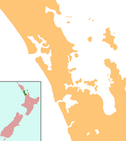
Clevedon, previously known as Wairoa South, is a rural town in Auckland, New Zealand, located in the Franklin ward, one of the thirteen administrative divisions of Auckland city. The town is governed by the Auckland Council. The town and surrounding rural area has a population of 2,508, and is the centre of an administrative ward of Manukau which takes in much of the largely rural area to the east of the urban heart of the city.

The Whangaehu River is a large river in central North Island of New Zealand. Its headwaters are the crater lake of Mount Ruapehu on the central plateau, and it flows into the Tasman Sea eight kilometres southeast of Whanganui. Water is diverted from the headwaters for the Tongariro Power Scheme.

SS Wairarapa was a New Zealand ship of the late 19th century plying the route between Auckland, New Zealand and Australia. It came to tragic fame when it hit a reef at the northern edge of Great Barrier Island, about 100 km out from Auckland, and sank. The death toll of around 140 people remains one of the largest such losses in the country's history. The ship was named for the Wairarapa region.

Blackpool is a settlement on Waiheke Island in northern New Zealand. It was named after Blackpool, which is a large town in England.

Princes Wharf is a former commercial wharf on the Auckland waterfront, in Auckland City, New Zealand, which has been redeveloped into a multi-story high-class mixed-use development and cruise ship terminal.

The Wynyard Quarter is a reclaimed piece of land on the Waitematā Harbour at the western edge of the Auckland waterfront, New Zealand.

The Auckland waterfront is a city-side stretch of the southern Waitematā Harbour coastline in Auckland, New Zealand. Previously mostly dominated by Ports of Auckland uses, from the 2000s on it is becoming increasingly open to recreational public use, with a number of former wharves being converted to office, entertainment, and later also some residential uses.
Sea Scouts New Zealand are part of the New Zealand Scouts Association. There are around 900 Sea Scouts in New Zealand in 53 troops around the country.

Kennedy Bay is a locality in the north eastern Coromandel Peninsula of New Zealand. The Harataunga and Omoho Streams flow from the Coromandel Range past the settlement and into the bay to the east.
Pukekohe High School is a high school in Pukekohe in the Auckland Region of New Zealand.

The Orere River is a river of the Auckland Region of New Zealand's North Island. It flows generally northeast from the Hunua Ranges, reaching the Firth of Thames at Orere Point, close to the point where the firth widens into the Hauraki Gulf.

Waitawa Regional Park is an Auckland regional park that opened in 2014 in New Zealand. The land was purchased in 2004 by the former Auckland Regional Council and the park is administered by the Auckland Council. The park is on the coastline in the Auckland Region, near Kawakawa Bay and Clevedon, and is about 50 km from central Auckland.