Related Research Articles

The Saybrook Colony was a short-lived English colony established in New England in 1635 at the mouth of the Connecticut River in what is today Old Saybrook, Connecticut. Saybrook was founded by a group of Puritan noblemen as a potential political refuge from the personal rule of Charles I. They claimed possession of the land via a deed of conveyance from Robert Rich, 2nd Earl of Warwick, which granted the colony the land from the Narragansett Bay to the Pacific Ocean. Saybrook was named in honor of two of its primary investors, the Lords Saye and Sele and Brooke. John Winthrop the Younger was contracted as the colony's first governor, but quickly left Saybrook after failing to enforce its authority over Connecticut's settlers. With Winthrop gone, Lion Gardiner was left in charge of Saybrook's considerable fort, defending it when it was besieged during the Pequot War. Governor George Fenwick arrived in the colony in 1639, but quickly saw it as a lost cause. Fenwick negotiated the colony's sale to Connecticut in 1644 after interest in colonization dried up due to the investors' involvement in the English Civil War. The colony's founding document, the Warwick Patent, was used to justify the existence of the Connecticut Colony, which lacked a formal charter until 1662.

The Hockanum River is a river in Connecticut. Hockanum is derived from the Native American Podunk people Algonquin language word meaning "hook-shaped", so named because of the course of the river. The Hockanum neighborhood in East Hartford is named after it.

The Scantic River is a river that flows through the states of Massachusetts and Connecticut. It is a tributary to the Connecticut River.

The Quaboag River is a 25.7-mile-long (41.4 km) river in Massachusetts that heads at Quaboag Pond in Brookfield at an elevation of 594 feet (181 m) above sea level. It flows west to the village of Three Rivers, Massachusetts, at an elevation of 290 feet (88 m).

The source of the Eightmile River is a swampy, undeveloped region in the town of East Haddam, Connecticut, centered between Ackley Road, Hall Kilbourne Road, Usher Swamp Road, and Miles Standish Road. The Eightmile River runs for 13.4 miles (21.6 km) to Hamburg Cove in the town of Lyme, Connecticut.

The Blackledge River is a tributary of the Salmon River which courses 16.4 miles (26.4 km) through eastern Connecticut in the United States.

The Salmon River is formed at the confluence of the Blackledge and Jeremy rivers about one mile west of North Westchester, Connecticut. It drains 96,000 acres and courses for 10.4 miles (16.7 km) to Salmon Cove near Moodus where it flows into the Connecticut River. The Salmon River is probably the largest stream and watershed whose sources and mouth are entirely within the limits of Connecticut.

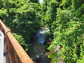
The Jeremy River, named after Jeremy Adams, begins at a drainage just north of Holbrook Pond about 1.5 miles (2.4 km) east of Gilead, Connecticut, and runs for 10.7 miles (17.2 km) to the Salmon River in Colchester, Connecticut. There are many swamps and marshes along the banks of its northern end, the largest of which is 1.5 miles (2.4 km) long.

The Hammonasset River is formed about 4 miles (6.4 km) southeast of Durham, Connecticut along a gully on the north end of Bunker Hill at about a half mile northeast of the junction of Route 148 and Bunker Hill Road. The river travels for 21.0 miles (33.8 km) to Clinton Harbor on Long Island Sound just east of Hammonasset Beach State Park. A popular paddling route runs for about 10 miles (16 km) starting along Summer Hill Road about 2.5 miles (4.0 km) south on Route 79 from North Madison, Connecticut. This is a scenic river run with mostly flat and quickwater, but with a few Class I-II whitewater areas.

The Ten Mile River is a 15.4-mile-long (24.8 km) river that flows through Dutchess County, New York, into westernmost Connecticut. The river is formed in the town of Amenia, New York, at the confluence of Webatuck Creek and Wassaic Creek. The Ten Mile River runs south through the town of Dover, New York before turning east and crossing into Connecticut, where it forms the boundary between the towns of Kent and Sherman for one-half mile before flowing into the Housatonic River. This is a popular whitewater paddling destination with mostly quickwater and a few whitewater areas reaching up to Class III.

The Mattabesset River as delineated on present-day maps flows out of Harts Ponds in the town of Berlin and travels 16.1 miles (25.9 km) east to the Connecticut River, passing Kensington and later forming the boundary between Middletown and Cromwell.
The Mill River is a 1.25-mile-long (2.01 km) tributary of the Connecticut River in Springfield, Massachusetts. It flows from Watershops Pond to its confluence with the Connecticut River. It is referred to as "The Miracle Mile" in a 2009 master's thesis that outlines possibilities for reclaiming the river's mouth as a recreational area. As of 2011, the final 350 feet (110 m) of the river, including its mouth, is confined in a pipe underneath Interstate 91, railroad tracks and a car dealership. Many Springfield residents have bemoaned the loss of the Mill River as a recreational area, and hope to gain greater access to both it and the Connecticut River in upcoming years. As it has for over a century, today the Mill River serves as a barrier between Springfield neighborhoods. Surrounding it are some of the most densely urbanized locations in Springfield.
The SS Narragansett was a passenger paddle steamer of the Stonington Line that burned and sank on June 11, 1880, after a collision with her sister ship the SS Stonington in Long Island Sound.
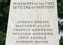
Jeremy Adams, also known as Jeremiah Adams, was one of the first settlers of Hartford, Connecticut. He was also the founder and first proprietor of Colchester, Connecticut, which was established on land owned by Adams, known as "Jeremiah's Farme".

The Duck River is a short, partly tidal stream in Old Lyme, Connecticut. It joins the Connecticut River in the estuary at Watch Rock Park, just above the point where the Connecticut flows into Long Island Sound.

The Pequabuck River is a river, approximately 19 miles (30.6 km) in length, which rises in Litchfield County, Connecticut, and courses through neighboring Hartford County before emptying into the Farmington River in Farmington. The river has played a crucial role in the development of Plainville, Connecticut, in particular. The river's lower drainage basin consists of industrial and urban areas, and effluents from these areas pollute the river's waters. The Pequabuck drove a water wheel that provided 8 horsepower to the Upper Lock Shop in Plymouth, Connecticut, a facility which would eventually become the Lewis Lock Company in 1851 and, finally, the once-renowned Eagle Lock Company. The river banks were historically the site of one of United States' first malleable iron-producing units, known as Malleable Iron Works.
Burdickville is a village and former mill town located within the town of Hopkinton in the U.S. state of Rhode Island. The village is located in the southeastern part of town and is near the border with Charlestown at the Pawcatuck River. Burdickville Road runs through it.
Grannis Island is an uninhabited island in the Quinnipiac River in New Haven, Connecticut. It is owned by the New Haven Land Trust as part of the Eugene B. Fargeorge Nature Preserve at Quinnipiac Meadows.
The Podunk River is a stream in Hartford County, Connecticut. It is a tributary to the Connecticut River.

Kings Island is the largest island in the Connecticut River and is located between Enfield and Suffield, Connecticut in Hartford County. Other names include Colonel John Pynchon's Island, Copper Island, Devotion Island, General Lyman Island, Great Island, Lyman Island, and Terry's Island The island is nearly a mile long and contains 104 Acres.