Centrum is a station on Line M1 of the Warsaw Metro, located under Plac Defilad, a square in the borough of Śródmieście, next to the Dmowski roundabout, where the two main streets, Marszałkowska and Aleje Jerozolimskie, intersect. It is located close to the Palace of Culture and Science and connections can be made, via Pasaż Wisławy Szymborskiej and Aleje Jerozolimskie at ground level, to Warszawa Śródmieście railway station which is in turn directly connected to Warszawa Centralna railway station. It has two levels: the lower one contains the platforms and the upper one is a shopping mall.

Jewish cemeteries of Warsaw refers to a number of Jewish necropolises in the city.
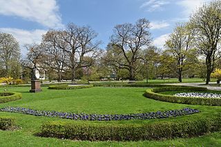
Ujazdów Park is one of the most picturesque parks of Warsaw, Poland. It borders Aleje Ujazdowskie, with its many embassies and Sejm building.

Marszałkowska Street, also known by its English name Marshal Street, is one of the main thoroughfares of Warsaw, Poland, located in the district of Downtown (Śródmieście). It runs along the north–south axis, from Bank Square in the north to the Union of Lublin Square in the south.

Wesoła is one of the districts of Warsaw, and has been as such since October 27, 2002. Wesoła is located in the south-eastern part of city.

Czysta is one of the neighborhoods of the Wola district of Warsaw, Poland. It is limited by Wolska and Towarowa streets from the north and east and by railway lines from the west and south.
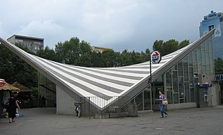
Warsaw Ochota is a railway station in Warsaw, Poland, located in the district of Ochota at Plac Zawiszy on the corner of Aleje Jerozolimskie and Towarowa Street. The station lies in a cutting. It has two island platforms, one on the suburban tracks of the Warsaw Cross-City Line for the regional trains run by Koleje Mazowieckie and Szybka Kolej Miejska and one for the Warszawska Kolej Dojazdowa light railway. The station building, at the street level, was constructed in 1963: it has a saddle roof in a distinct shape of a hyperbolic paraboloid. It was including escalator then. The location allows for convenient interchange with city trams and buses serving the western part of the city centre.

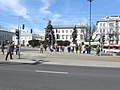
Parade Square is a square in downtown Warsaw, laying between Świętokrzyska Street to the north, Aleje Jerozolimskie to the south, Marszałkowska Street to the east and the monumental Palace of Culture and Science to the west. With 147,000 m2 (1,580,000 sq ft) of extension, it is the largest city square in Europe and one of the largest in the world.

The Zesłańców Syberyjskich Roundabout is a roundabout in western Warsaw's Ochota district, named after Poles who have been exiled to Siberia.
Ujazdów Avenue is a major thoroughfare parallel to the Vistula River in the downtown district of Warsaw, Poland.

Młynów is a neighbourhood of the western borough of Wola in Warsaw, the capital of Poland.

Artur Zawisza Square is a public square in Warsaw's borough of Ochota. It is named after Artur Zawisza, a 19th-century Polish revolutionary who was executed on the spot by Russians in 1833.
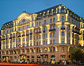
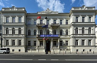
The Polonia Palace Hotel is a historic four-star hotel opened in 1913 and located in the heart of Warsaw on Jerusalem Avenue. It is the capital’s second oldest hotel after the Hotel Bristol, Warsaw. Together with the adjacent Metropol Hotel and the MDM Hotel, it is managed by the Syrena Hotel Group. It was declared an architectural monument of Poland's history and culture on July 1, 1965.

Silesian–Dąbrowa Bridge is a bridge over the Vistula River in Warsaw. It was built from 1947 to 1949 on the pillars which remained from the Kierbedzia Bridge which had been destroyed in World War II. Due to the bridge's completely different structure, it is recognized as a new bridge, not a rebuilt one.
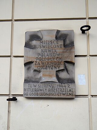
Massacre on Bracka Street - a series of murders, arson and other serious violations of the wartime law committed by soldiers of the German Wehrmacht during attempts to unblock the section of Jerozolimskie Avenue held by the insurgents in Warsaw.

Ujazdów is a prominent neighbourhood situated in central Warsaw, the capital of Poland. It is the southernmost part of the Downtown (Śródmieście) district, next to Solec and historical Frascati. The main thoroughfare passing through the neighbourhood is Ujazdów Avenue; the Chancellery of the Prime Minister of Poland, the Foreign Ministry and the Belweder Palace are located on or in the vicinity of the street. Ujazdów is an affluent neighbourhood, with villas, palaces and parks comprising most of its area. The most notable landmarks are the Łazienki Park and Palace on the Isle, the 18th century summer residence of Poland's last monarch Stanisław II Augustus.

Blue City is a postmodernist shopping centre in Warsaw, Poland, located at 179 Jerusalem Avenue within the district of Ochota. It was opened in 2004.

Reduta, formerly known as Atrium Reduta, is a shopping centre in Warsaw, Poland, located at 148 Jerusalem Avenue within the district of Ochota. It was opened in 1999.
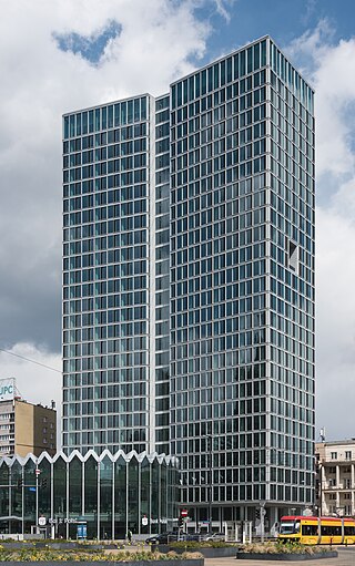
Widok Towers is an office skyscraper in Warsaw, Poland, located at 44 Jerusalem Avenue, in the Downtown district. It was designed by Piotr Bujnowski and Martin Tröthan, and opened in 2020.