Related Research Articles

Lebanon, officially the Republic of Lebanon, is a country in the Levant region of West Asia. It is bordered by Syria to the north and east, by Israel to the south, and by the Mediterranean Sea to the west; Cyprus lies a short distance away from the country's coastline. Lebanon's location at the crossroads of the Mediterranean Basin and the Arabian hinterlands has contributed to the country's rich history and shaped a unique cultural identity shaped by religious diversity. Lebanon has a population of more than five million people and covers an area of 10,452 square kilometres (4,036 sq mi). Lebanon's capital and largest city is Beirut, followed by Tripoli and Jounieh. While Arabic is the official language, French is also recognized in a formal capacity; Lebanese Arabic is the country's vernacular, though French and English play a relatively significant role in everyday life, with Modern Standard Arabic being limited to news and government matters.

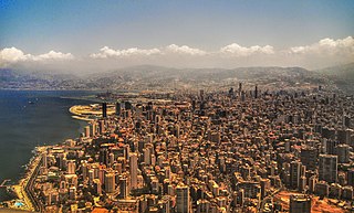
Beirut is the capital and largest city of Lebanon. As of 2014, Greater Beirut has a population of 2.5 million, which makes it the third-largest city in the Levant region and the thirteenth-largest in the Arab world. The city is situated on a peninsula at the midpoint of Lebanon's Mediterranean coast. Beirut has been inhabited for more than 5,000 years, making it one of the oldest cities in the world.

Achrafieh is an upper-class area in eastern Beirut, Lebanon. In strictly administrative terms, the name refers to a sector (secteur) centred on Sassine Square, the highest point in the city, as well as a broader quarter (quartier). In popular parlance, however, Achrafieh refers to the whole hill that rises above Gemmayze in the north and extends to Badaro in the south, and includes the Rmeil quarter.

Martyrs' Square, historically known as "Al Burj" or "Place des Cannons", is the historical central public square of Beirut, Lebanon.

Aley is a major city in Lebanon. It is the capital of the Aley District and fourth largest city in Lebanon.

Haret Hreik is a mixed Shia and Maronite Christian municipality, in the Dahieh suburbs, south of Beirut, Lebanon. It is part of the Baabda District. Once an agricultural village, Haret Hreik lost its rural identity due to the wave of refugees from Southern Lebanon who settled in the town and made it another urban neighborhood of Dahieh.

The Beirut Central District is the historical and geographical core of Beirut, the capital of Lebanon. Also called downtown Beirut, it has been described as the “vibrant financial, commercial, and administrative hub of the country.” It is thousands of years old, with a traditional focus of business, finance, culture, and leisure.

Beirut, the capital of Lebanon, is home to two hippodromes, a historic one from the Roman era and a modern one that was built in the late 19th century.

The Holy Spirit University of Kaslik is a private, non-profit, Catholic university in Jounieh, Lebanon. The university was founded in 1950 and ratified under the new Higher Education Law of 1962. USEK is the first university in Lebanon to be established by Lebanese citizens.

The Beirut River is a river in Lebanon separating the city of Beirut from its eastern suburbs, primarily Bourj Hammoud and Sin el Fil. The river flows mostly east to west from snow drains and springs on the western slopes of Mount Kneisseh and the southern end of Mount Sannine near the towns of Hammana and Falougha, before curving north and emptying at Beirut's northern Mediterranean coast, east of the Port of Beirut. According to popular legend, St. George slew the dragon in a spot near the mouth of the river.

Beirut Souks is a major commercial district in Beirut Central District. With over 200 shops, 25 restaurants and cafes, an entertainment center, a 14 cinema complex, periodic street markets and an upcoming department store, it is Beirut's largest and most diverse shopping and leisure area. Beirut Souks also features piazzas and public space. Designed in five separate commissions by international and Lebanese architects, Beirut Souks offer 128,000 sq. m of built-up area interspersed with landscaped pedestrian zones.
Badaro is a residential neighborhood and business hub in the heart of Beirut, Lebanon. The neighborhood is roughly bounded by the Pierre Gemayel avenue on the north, the Hippodrome on the west, Sami el Solh avenue on the east, Beirut's pine forest on the southeast, and the Tayyouneh roundabout on the south. Badaro is the common name of Beirut's "Horsh" (park) administrative district, which also includes three parks: a75 acres (30 ha) pine forest known as Horsh Beirut, the Beirut Hippodrome and the Pine Residence, the French ambassador's residence.
The Archeparchy of Beirut and Byblos is a metropolitan eparchy of the Melkite Greek Catholic Church since 1881, an Eastern Catholic church in communion with the Roman Catholic Church. Located in Lebanon, it includes the cities of Beirut and Byblos, and in terms of population, it is the largest Melkite eparchy in the Middle East. Its current Eparch, Georges Wadih Bacouni, S.M.S.P., was elected in November 2018.

The architecture of Lebanon embodies the historical, cultural and religious influences that have shaped Lebanon's built environment. It has been influenced by the Phoenicians, Romans, Byzantines, Umayyads, Crusaders, Mamluks, Ottomans and French. Additionally, Lebanon is home to many examples of modern and contemporary architecture. Architecturally notable structures in Lebanon include ancient thermae and temples, castles, churches, mosques, hotels, museums, government buildings, souks, residences and towers.
The Phoenician port of Beirut, also known as the Phoenician Harbour of Beirut and archaeological site BEY039 is located between Rue Allenby and Rue Foch in Beirut, Lebanon. Studies have shown that the Bronze Age waterfront lay around 300 metres (330 yd) behind the modern port due to coastal regularisation and siltation. It was excavated and reported on by Josette Elayi and Hala Sayegh in 2000 and determined to date to the Iron Age III and Persian periods. Two nineteenth-century Ottoman docks were also unearthed during construction, just to the north of this area at archaeological sites BEY018 and BEY019.
The Association for the Protection of the Lebanese Heritage or APLH is a cultural heritage, non-governmental organization based in Zouk Mosbeh, Keserwan District of Mount Lebanon, Lebanon.
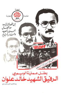
The Wimpy Operation was an attack on Israeli soldiers in Hamra, a neighbourhood in the west of the Lebanese capital Beirut on September 24, 1982 during the 1982 Lebanon War. The Wimpy Operation has a strong symbolic significance, as it marked the start of the campaign against Israeli forces in Beirut.
The Beirut Heritage Trail is a project undertaken by Solidere with the support of the Ministry of Culture and the Municipality of Beirut. Marked out by bronze medallions grouted into the sidewalk, the trail will link archeological sites, historic public spaces and heritage buildings over a 2.5 km walking circuit in the historic core of Beirut.
The earliest settlement of Beirut was on an island in the Beirut River, but the channel that separated it from the banks silted up and the island ceased to be. Excavations in the downtown area have unearthed layers of Phoenician, Hellenistic, Roman, Byzantine, Arab, Crusader, and Ottoman remains.

The 17 October Protests, commonly referred to as the 17 October Revolution or as Hirak were a series of civil protests in Lebanon that began after the Lebanese cabinet announced financial measures on 17 October 2019. These national protests were triggered by planned taxes on gasoline, tobacco, and VoIP calls on applications such as WhatsApp, but quickly expanding into a country-wide condemnation of sectarian rule, the stagnation of the economy, unemployment, endemic corruption in the public sector, legislation that was perceived to shield the ruling class from accountability and failures of the government to provide basic services such as electricity, water, and sanitation.
References
- 1 2 "The Jesuit Garden in Geitawi". Beirut.com. Archived from the original on 2019-02-26. Retrieved 2017-09-18.
- ↑ Lutz, Meris., Residents, activists fight to preserve Ashrafieh’s Jesuit Garden, Daily Star, June 10, 2013
- ↑ Duplan, Charlie., "Le Jardin des Jésuites n'est pas à vendre", L'Orient Le Jour, 16/06/2013
- ↑ The Jesuit Garden [129 D2] (Moscou St, o Charles Malek Av, Achraeh; 07.00–17.00 daily)
- 1 2 Anderson, Brook., Protest over parking garage plans at Beirut Jesuit Garden, Daily Star (Lebanon), June 15, 2013.
- ↑ Karam, Michael., Green space losing out to the obsession to drive everywhere, The National, Jun 14, 2013