
Manang District (Nepali: मनाङ जिल्ला, in Gandaki Province, is one of the seventy-seven districts of Nepal. The district, with Chame as its district headquarters, covers an area of 2,246 km2 and in 2011 had a population of 6,538.

Mustang District is one of the eleven districts of Gandaki Province and one of seventy-seven districts of Nepal which was a Kingdom of Lo-Manthang that joined the Federation of Nepal in 2008 after abolition of the Shah dynasty. The district covers an area of 3,573 km2 (1,380 sq mi) and in 2011 had a population of 13,452. The headquarters is located at Jomsom. Mustang is the fifth largest district of Nepal in terms of area.

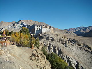
Lomanthang is a rural municipality in Mustang district in Gandaki Province of western Nepal. It is located at the northern end of the district, bordering the Tibet Autonomous Region of China to the north and Dalome rural municipality of Mustang in the south.

Jomsom, also known as Dzongsam, is the centre of Gharapjhong rural municipality in Mustang district and a former independent village development committee situated at an altitude of about 2,700 metres (8,900 ft) in Gandaki Province of western Nepal. The soaring peaks of Dhaulagiri and Nilgiri form a backdrop to the town straddling the Kali Gandaki River, which flows right through the centre of Jomsom. Along the banks of the Kali Gandaki, black fossilised stones called shaligram, considered as an iconic symbol and reminder of the god Vishnu in the Hindu culture, can be found. Such stones are believed to be found only in the Kali Gandaki, and are considered holy by Hindus.

A village development committee in Nepal was the lower administrative part of its Ministry of Federal Affairs and Local Development. Each district had several VDCs, similar to municipalities but with greater public-government interaction and administration. There were 3,157 village development committees in Nepal. Each village development committee was further divided into several wards depending on the population of the district, the average being nine wards.
The 1991 Nepal census was a widespread national census conducted by the Nepal Central Bureau of Statistics.
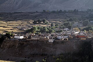
Charang (Tsarang) is a village development committee in Mustang District in the Dhawalagiri Zone of northern Nepal. At the time of the 1991 Nepal census it had a population of 682 people living in 130 individual households.
Chhonhup is a village development committee in Mustang District in the Dhawalagiri Zone of northern Nepal. At the time of the 1991 Nepal census it had a population of 1047 people living in 192 individual households.

Chhoser (also known as Garphu) is a village development committee in Mustang District in the Dhawalagiri Zone of northern Nepal. At the time of the 1991 Nepal census it had a population of 728 people living in 168 individual households.

Chhusang is a village development committee in Mustang District in the Dhawalagiri Zone of northern Nepal. It is located on the Upper Mustang trekking route, between Tangbe and Chele, about an hour's walk north of Tangbe. It lies at the junction of the Narshing river and the Kali Gandaki.
Dhami, Nepal is a village development committee in Mustang District in the Dhawalagiri Zone of northern Nepal. At the time of the 1991 Nepal census it had a population of 850 people living in 158 individual households.
Kowang is a village in Mustang District and former village development committee (VDC) in the Dhawalagiri Zone of northern Nepal. At the time of the 1991 Nepal census it had a population of 659 people living in 170 individual households.
Kunjo is a village development committee in Mustang District in the Dhawalagiri Zone of northern Nepal. At the time of the 2011 Nepal census it had a population of 711 people living in 174 individual households. The split per gender was approximately 52,6% male population and 47,4% female population.

Lete is a village development committee in Mustang District in the Dhawalagiri Zone of northern Nepal. At the time of the 1991 Nepal census it had a population of 914 people living in 189 individual households. It is a scenic village surrounded by Dhawalagiri, Annapurna and Nilgiri. This village is governed by chairman the, Ama-Samuha, and other members.
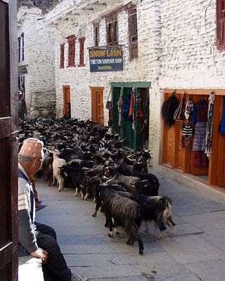
Marpha is a village in Mustang District in the Dhawalagiri Zone of northern Nepal. At the time of the 1991 Nepal census it had a population of 1630 people living in 434 individual households.
Surkhang is a village development committee in Mustang District in the Dhawalagiri Zone of northern Nepal. At the time of the 1991 Nepal census it had a population of 651 people living in 130 individual households.

Tukuche, sometimes spelt Tukche, is a village development committee in Mustang District in the Dhawalagiri Zone of northern Nepal. At the time of the 1991 Nepal census it had a population of 652 people living in 166 individual households.

Ngawal (Nawal) is a village development committee in Manang District in the Gandaki Zone of northern Nepal. At the time of the 2011 Nepal census it had a population of 274. Ngawal VDC is one of the Seven Village Development Committee in Upper Manang. One of the main attraction of this village is a centuries-old cave of Guru Rinpoche that is on the hills overlooking Ngawal village. The local people believes the cave leads to Mustang. And a monastery in Tibetan Nyingma pa sect which is called Portoche Monastery. 16
Lo-Ghekar Damodarkunda (earlier:Dalome) is a rural municipality situated in Mustang District of Gandaki Province of Nepal. The municipality is situated on the northern part of the Mustang, surrounded by Lomanthang rural municipality on the north, Barhagaun Muktichhetra on the south, Manang District on the south-east and Dolpa District on the west, while the north-eastern border of the rural municipality touches the border of Tibet in southwest China.


