Related Research Articles

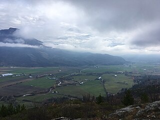
Salmon Arm is a city in the Columbia Shuswap Regional District of the Southern Interior of the Canadian province of British Columbia that has a population of 17,706 (2016). Salmon Arm was incorporated as a municipal district on May 15, 1905. The city of Salmon Arm separated from the district in 1912, but was downgraded to a village in 1958. In 1970, the city of Salmon Arm once again reunited with the District Municipality. Salmon Arm once again became a city in 2005, and is now the location of the head offices of the Columbia-Shuswap Regional District. It is a tourist town in the summer, with many beaches, camping facilities and house boat rentals. Salmon Arm is home to the longest wooden freshwater wharf in North America.

The Thompson River is the largest tributary of the Fraser River, flowing through the south-central portion of British Columbia, Canada. The Thompson River has two main branches, the South Thompson River and the North Thompson River. The river is home to several varieties of Pacific salmon and trout. The area's geological history was heavily influenced by glaciation, and the several large glacial lakes have filled the river valley over the last 12,000 years. Archaeological evidence shows human habitation in the watershed dating back at least 8,300 years. The Thompson was named by Fraser River explorer, Simon Fraser, in honour of his friend, Columbia Basin explorer David Thompson. Recreational use of the river includes whitewater rafting and angling.

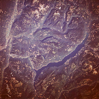
Shuswap Lake is a lake located in the southern interior of British Columbia, Canada that drains via the Little Shuswap River into Little Shuswap Lake. Little Shuswap Lake is the source of the South Thompson River, a branch of the Thompson River, a tributary of the Fraser River. It is at the heart of a region known as the Columbia Shuswap or "the Shuswap", noted for its recreational lakeshore communities including the city of Salmon Arm. The name "Shuswap" is derived from the Shuswap or Secwepemc First Nations people, the most northern of the Interior Salish peoples, whose territory includes the Shuswap. The Shuswap call themselves /ʃǝxwépmǝx/ in their own language, which is called /ʃǝxwepmǝxtʃín/.
The British Columbia Hockey League (BCHL) is a Junior A ice hockey league from British Columbia under Hockey Canada and BC Hockey. Founded in Vernon in 1961, the BCHL now includes 18 teams.

The City of Enderby is in the North Okanagan region of the Canadian province of British Columbia, between Armstrong and Salmon Arm. It is approximately 80 km north of Kelowna and 130 km east of Kamloops. Highway 97A passes through Enderby and the Shuswap River marks the eastern and northeastern limits of the City. There are two major schools in Enderby: M.V. Beattie Elementary School and A.L. Fortune Secondary School. M.V. Beattie Elementary School was rebuilt in 2012.
Adams Lake is a deep, cold-water lake in south-central British Columbia, which separates the Thompson and Shuswap regions and the Thompson–Nicola and Columbia–Shuswap regional districts. The upper reaches lie in the northern Monashee Mountains, while the lower end penetrates the Shuswap Highland. The southern end is by road about 79 kilometres (49 mi) northeast of Kamloops.
The basin of the Shuswap River lies northeast of the Okanagan Valley in British Columbia, originating in the central Monashee Mountains. It is the upper part of the drainage better known to British Columbians as belonging to Shuswap Lake and the South Thompson River. The river's drainage basin is over 1,969 square kilometres (760 sq mi) in area.
Porcupine Meadows Provincial Park is a 2,704 hectare provincial park in British Columbia, Canada, located north of Tranquille Lake to the northwest of Kamloops. Its name is a direct translation of the Shuswap word for this area, "pisitsoolsia", named so for the numerous porcupine in the area.

Tsútswecw Provincial Park is a provincial park in British Columbia, Canada, located northeast of Kamloops and northwest of Salmon Arm. It stretches along the banks of the Adams River, between the south end of Adams Lake and the western portion of Shuswap Lake.

Shuswap Lake Provincial Park is a provincial park in British Columbia, Canada.

The Secwépemc, known in English as the Shuswap people, are a First Nations people residing in the interior of the Canadian province of British Columbia. They speak one of the Salishan languages, known as Secwepemc or Shuswap.

The British Columbia Interior, popularly referred to as the BC Interior or simply the Interior, is a geographic region of the Canadian province of British Columbia. While the exact boundaries are variously defined, the British Columbia Interior is generally defined to include the 14 regional districts that do not have coastline along the Pacific Ocean or Salish Sea, and are not part of the Lower Mainland. Other boundaries may exclude parts of or even entire regional districts, or expand the definition to include the regional districts of Fraser Valley, Squamish–Lillooet, and Kitimat–Stikine.
The Little Shuswap Indian Band is a First Nations band government of a community of the Secwepemc (Shuswap) Nation, located in the Central Interior region of British Columbia, Canada. Its main Indian reserve is in Chase, British Columbia, sometimes marked Squilax on maps is properly called Quaaout, and is on the shore of Little Shuswap Lake. It was created when the government of the then-Colony of British Columbia established an Indian Reserve system in the 1860s. It is a member government of the Shuswap Nation Tribal Council.

Thompson Country, also referred to as The Thompson and sometimes as the Thompson Valley and historically known as the Couteau Country or Couteau District, is a historic geographic region of the Southern Interior of British Columbia, more or less defined by the basin of the Thompson River. This is a tributary of the Fraser; the major city in the area is Kamloops.

The Adams River is a tributary to the Thompson and Fraser Rivers in British Columbia, Canada. Beginning in the Monashee Mountains to the north, the Upper Adams River flows mainly southward and eventually reaches Adams Lake. The Lower Adams River begins at the southern end of the lake and flows into the extreme western end of Shuswap Lake. The river is one of the most important sockeye salmon breeding areas in North America. The run occurs in mid-October and can bring millions of fish to a concentrated area near the river mouth. Excavations of Secwepemc villages on the river have shown a long tradition of habitation and salmon fishing in the area. The river also served as an important transportation route for early logging operations in the watershed.
The Salmon River is a river in the Shuswap region of British Columbia, Canada.
The Salmon Arm Roots and Blues Festival is a three-day music festival that occurs every third weekend in August. It has four - six stages and features an international roster of artists as well as a strong contingent of Canadian talent. The event takes place at the Salmon Arm Fair Grounds, an 18-acre site at the base of Mount Ida in Salmon Arm, a town located on the shores of the Shuswap Lake in British Columbia.
The Anstey River is a 30-kilometre-long (19 mi) river in the Interior region of British Columbia, Canada. It flows roughly north to south from the Monashee range of the Columbia Mountains, and drains into Anstey Arm on Shuswap Lake. The Anstey River drainage covers 24,000 hectares and is uninhabited. The river was named for Francis Senior Anstey, who operated one of the first major logging operations in the area. The lower river and its delta are protected within Anstey Hunakwa Provincial Park.
The Perry River, sometimes referred to as the North Fork of the Eagle River, is a mountain river in the interior of British Columbia, Canada. It flows out of the Monashee Mountains and joins the Eagle River near the town of Malakwa. It is part of the Thompson River system, which drains into the Fraser River. The river's watershed area is 43,646 hectares (169 sq mi), and major tributaries to the river include Bews and Rocky creeks.

Mount Ida, also known as Kela7scen, is a 1,574 m (5,164 ft) high mountain of Shuswap Highland located in the southern portion of Columbia-Shuswap Regional District. The mountain resembles a defensive palisade and overlooks the city of Salmon Arm from the south.
References
- ↑ Forsythe, Mark. "#157 Shuswap gets its due | BC Booklook". bcbooklook.com. Retrieved 2018-03-18.
- ↑ "Jim Cooperman | Ricochet". Ricochet. Retrieved 2018-03-18.
- ↑ Brouwer, Barb (2014-10-07). "25 years of environmental action - Salmon Arm Observer". Salmon Arm Observer. Retrieved 2018-03-18.
- ↑ Fortems, Cam (2017-07-20). "Review: Author's passion for area evident in Everything Shuswap - Kamloops This Week". Kamloops This Week. Retrieved 2018-03-18.
- ↑ Sandborn, Tom (2018-01-16). "A love letter to one of B.C.'s magical, lesser-known regions". Vancouver Sun. Retrieved 2018-03-18.