Related Research Articles

Mount Garibaldi is a dormant stratovolcano in the Garibaldi Ranges of the Pacific Ranges in southwestern British Columbia, Canada. It has a maximum elevation of 2,678 metres and rises above the surrounding landscape on the east side of the Cheakamus River in New Westminster Land District. Mount Garibaldi contains three summits, two of which are individually named. Atwell Peak is a sharp, conical summit slightly higher than the more rounded summit of Dalton Dome. Both summits were volcanically active at different times throughout Mount Garibaldi's eruptive history. The northern and eastern flanks of Mount Garibaldi are obscured by the Garibaldi Névé, a large snowfield containing several radiating glaciers. Flowing from the steep western face of Mount Garibaldi is the Cheekye River, a tributary of the Cheakamus River. Opal Cone on the southeastern flank is a small volcanic cone from which a lengthy lava flow descends. The western face is a landslide feature that formed in a series of collapses between 12,800 and 11,500 years ago. These collapses resulted in the formation of a large debris flow deposit that fans out into the Squamish Valley.

Garibaldi Provincial Park, also called Garibaldi Park, is a wilderness park located on the coastal mainland of British Columbia, Canada, 70 kilometres (43.5 mi) north of Vancouver. It was established in 1920 and named a Class A Provincial Park of British Columbia in 1927. The park is a popular destination for outdoor recreation, with over 30,000 overnight campers and over 106,000 day users in the 2017/2018 season.
Haberl is a surname. Notable people with the surname include:

The Tantalus Range is a subrange of the Pacific Ranges of the Coast Mountains in southern British Columbia, Canada. The range is easily viewed from the "Sea to Sky Highway" that travels from Vancouver to Squamish and Whistler. To Squamish people, the local indigenous people of the area, the name of the Tantalus Range is Tsewílx’.

The Tonquin Valley is located in Jasper National Park, Alberta, Canada, next to the border of the provinces of Alberta and British Columbia, an area which is also the continental divide, running along the peaks of the South Jasper Range which rise above Amethyst Lake. Tonquin Creek drains Moat Lake and flows west into Mount Robson Provincial Park in British Columbia, and empties into the Fraser River. The Astoria River drains south and east into the Athabasca River.
The Alpine Club of Canada (ACC) is an amateur athletic association with its national office in Canmore, Alberta that has been a focal point for Canadian mountaineering since its founding in 1906. The club was co-founded by Arthur Oliver Wheeler, who served as its first president, and Elizabeth Parker, a journalist for the Manitoba Free Press. Byron Harmon, whose 6500+ photographs of the Canadian Rockies in the early 20th century provide the best glimpse of the area at that time, was official photographer to the club at its founding. The club is the leading organization in Canada devoted to climbing, mountain culture, and issues related to alpine pursuits and ecology. It is also the Canadian regulatory organization for climbing competition, sanctioning local, regional and national events, and assembling, coaching and supporting the national team.
The Stanley Mitchell hut is an alpine hut located at an altitude of 2,060 metres (6,759 ft) in the Little Yoho Valley in Yoho National Park, British Columbia. It sits in a small meadow not far from the base of a mountain called The President. It serves as a base for hiking, scrambling, ski-touring and climbing the nearby mountains. The hut is maintained by the Alpine Club of Canada.

The Elizabeth Parker hut is an alpine hut located in Yoho National Park near Lake O'Hara in British Columbia. The hut is maintained by the Alpine Club of Canada.
The Elk Lakes cabin is an alpine hut located between the French and Italian Military Groups in the Canadian Rockies. It resides near the Continental Divide in Elk Lakes Provincial Park, British Columbia. It is 62 km south of the Trans-Canada Highway in Kananaskis Country, Alberta and 104 km north of Sparwood, British Columbia. The area has hiking trails, and provides access to mountaineering objectives. In winter, ice climbs and skiing terrain with much powder abound. Elk Lakes terrain is similar to that near the Elizabeth Parker hut. The hut is maintained by the Alpine Club of Canada.

The Arthur O. Wheeler hut is an alpine hut located four km southwest of Rogers Pass in Glacier National Park, British Columbia. Although not truly a backcountry hut, this log cabin is situated conveniently close to the Trans-Canada Highway in the Selkirk Mountains, west of the Rocky Mountains. It is often used as a base for mountaineering, hiking, and ski touring into the Asulkan Range and Illecillewaet Glacier areas south of the highway, and the Hermit Range north of the highway. The hut is maintained by the Alpine Club of Canada (ACC). It is the only ACC hut which can be reached by vehicle.
The Abbot Pass hut was an alpine hut located at an altitude of 2,925 metres (9,596 ft) in Abbot Pass in the Rocky Mountains in Alberta, Canada. It was nestled between Mount Victoria and Mount Lefroy, straddling the Great Divide, which, in this region, defines the boundary between Banff National Park in Alberta and Yoho National Park in British Columbia. While close to the border, the hut lay entirely in Banff National Park, and was the second-highest permanently habitable structure in Canada. The hut was maintained by the Alpine Club of Canada.
The Fay hut was an alpine hut located above Prospectors Valley in Kootenay National Park, British Columbia. Although the higher Neil Colgan hut superseded it as a base for climbs in the Valley of the Ten Peaks area, it still served as a convenient base for hikers and skiers doing day trips in the area, and as an overnight stop for mountaineers continuing on to the Neil Colgan hut. A new hut was built in 2005 to replace the original Fay hut, which was destroyed by a forest fire in 2003. The Fay hut was maintained by the Alpine Club of Canada (ACC).

The Bill Putnam hut is an alpine hut located in the Adamant range of the Selkirk mountains in British Columbia. It is set on a knoll at the edge of a high mountain meadow and provides access to a great array of mountaineering objectives, but is best known for its spectacular skiing terrain. The hut is maintained by the Alpine Club of Canada.

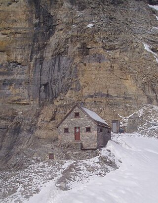
Serratus Mountain is a jagged, ridge-like mountain between Mount Tantalus (North) and Lake Lovely Water (South). Like most other peaks in the Tantalus Range, it is composed of loose rock. Most routes here are scrambles. The mountain is a standard single-day destination from the Jim Haberl hut.
The Bow Hut is an alpine hut located at an elevation of 2,350 metres (7,710 ft) on the eastern edge of the Wapta Icefield in Banff National Park. It is the largest, best equipped, and most accessible of the four alpine huts on the Wapta Icefield, and serves as the base for a wide variety of ski tours and mountaineering ascents to half a dozen peaks on the Wapta. It is the easiest and safest starting point for the Wapta traverse; and Balfour Hut, the next hut on the traverse, can easily be reached from it in a day. It can also serve as an intermediate stop in a longer traverse which starts at the less easily accessible Peyto Hut. The hut is maintained by the Alpine Club of Canada.

The R.J. Ritchie Hut is an alpine hut located at an altitude of 2,470 metres (8,100 ft) between the southern tip of the Wapta Icefield and the northern tip of the Waputik Icefield in Banff National Park. The hut is at the half-way mark for the Wapta traverse and is usually used in conjunction with the other huts in this chain while attempting a cross-glacier ski trip. The hut is maintained by the Alpine Club of Canada.
The Neil Colgan Hut is an alpine hut located at an altitude of 2,957 metres (9,701 ft) on the Fay Glacier in Kootenay National Park in British Columbia, Canada. It is in a col between Mount Little and Mount Bowlen, one of the peaks overlooking the Valley of the Ten Peaks. The hut is maintained by the Alpine Club of Canada and is the highest permanent structure in Canada. It is named for hiker and adventurer Neil M. Colgan (1953–1979).

Mount Tantalus is a 2,608-metre (8,556-foot) mountain in southwestern British Columbia, Canada, located 24 km (15 mi) southeast of Falk Lake and 134 km (83 mi) south of Monmouth Mountain. It is the highest mountain in the Tantalus Range of the Pacific Ranges and is famous for its snow-covered face.
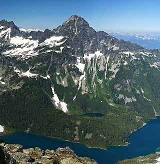
Alpha Mountain is a 2,302-metre (7,552-foot) summit located in the Tantalus Range, in Tantalus Provincial Park, in southwestern British Columbia, Canada. It is situated 14 km (9 mi) northwest of Squamish, and 4.6 km (3 mi) southeast of Mount Tantalus, which is the highest peak in the Tantalus Range. Its nearest higher peak is Serratus Mountain, 1.9 km (1 mi) to the west. The Serratus Glacier lies to the west of Alpha, unnamed glaciers lie on the northern and eastern slopes, and Lake Lovely Water lies below the south slope. Precipitation runoff from the peak drains into tributaries of the Squamish River.

Mount Dione is a 2,589-metre (8,494-foot) summit located in the Tantalus Range, in Tantalus Provincial Park, in southwestern British Columbia, Canada. It is situated 17 km (11 mi) northwest of Squamish, and 0.24 km (0 mi) north of Mount Tantalus, which is its nearest higher peak and the highest peak in the Tantalus Range. The Dione Glacier lies on the southern slope, and the Rumbling Glacier lies to the northeast. Precipitation runoff from the peak drains east into tributaries of the Squamish River, or west into tributaries of the Clowhom River. The first ascent of the mountain was made in 1916 by Tom Fyles and his brother, John Fyles, via the southeast ridge. The mountain names in the Tantalus Range have a Greek mythology theme, and Mount Dione was named for Dione, the wife of Tantalus. The mountain's name was submitted by Neal Carter of the British Columbia Mountaineering Club, and was officially adopted on June 6, 1957, by the Geographical Names Board of Canada.
References
- ↑ Westwide Avalanche Network accident report Archived 2006-01-06 at the Wayback Machine , seen 2006-10-11
- ↑ Jim Haberl fund's hut announcement Archived 2006-09-02 at the Wayback Machine
49°47′57″N123°18′35″W / 49.79917°N 123.30972°W