
Alagoas is one of the 27 federative units of Brazil and is situated in the eastern part of the Northeast Region. It borders: Pernambuco ; Sergipe (S); Bahia (SW); and the Atlantic Ocean (E). Its capital is the city of Maceió. It has 1.6% of the Brazilian population and produces 0.8% of the Brazilian GDP. It is made up of 102 municipalities and its most populous cities are Maceió, Arapiraca, Palmeira dos Índios, Rio Largo, Penedo, União dos Palmares, São Miguel dos Campos, Santana do Ipanema, Delmiro Gouveia, Coruripe, Marechal Deodoro, and Campo Alegre.

The São Francisco River is a large river in Brazil. With a length of 2,914 kilometres (1,811 mi), it is the longest river that runs entirely in Brazilian territory, and the fourth longest in South America and overall in Brazil. It used to be known as the Opara by the indigenous people before colonisation, and is today also known as "Velho Chico".

Maceió, formerly sometimes Anglicised as Maceio, is the capital and the largest city of the coastal state of Alagoas, Brazil. The name "Maceió" is an Indigenous term for a spring. Most maceiós flow to the sea, but some get trapped and form lakes.

Alagoa is a city in the Brazilian state of Minas Gerais. In 2020 its population was estimated to be 2,665.

Coruripe is a municipality located in the southern coast of the Brazilian state of Alagoas. Its population is 57,294 (2020) and its area is 913 km². It is the largest municipality in Alagoas by area, but among the largest municipalities of each Brazilian state, it is the smallest. It is situated at the edge of Coruripe river.

Maragogi is a municipality in the Brazilian state of Alagoas, 125 km north of the capital city of Maceió. It has 33,032 inhabitants, a city situated on the northern coast of Alagoas state, Brazil, being the easternmost city of that state.
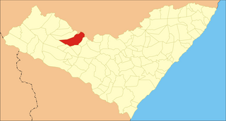
Santana do Ipanema is a municipality in the western half of the Brazilian state of Alagoas. It was founded in 1875 on the banks of the Ipanema river.

Piaçabuçu is a municipality located in the Brazilian state of Alagoas. It is the southernmost municipality in Alagoas, and lies near both São Francisco River and the Atlantic Ocean. Its population was 17,848 (2020) and its area is 240 km².
The Mundaú River is a river in northeastern Brazil. The Mundaú originates in the Borborema Plateau of Pernambuco state, and flows southeast through Pernambuco and Alagoas states to empty into the Mundaú Lagoon at Maceió, Alagoas' capital. Mundaú Lagoon is an estuary, connected to the Atlantic Ocean and Manguaba Lagoon to the south by a network of channels.
The Paraíba do Meio River is a river in Alagoas state of northeastern Brazil. It flows southeast to empty into Manguaba Lagoon, an estuarine lake connected to the Atlantic Ocean by a network of channels.

The Moxotó River is a tributary of the São Francisco River in northeastern Brazil. The Moxotó originates on the Borborema Plateau in Pernambuco state, and flows southwest to join the São Francisco. The lower portion of the river forms the border between Pernambuco state to the west and Alagoas state to the east.
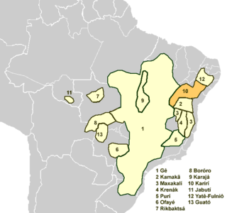
The Karirí languages, generally considered dialects of a single language, were a group of languages formerly spoken by the Kiriri people of Brazil. It was spoken until the middle of the 20th century; the 4,000 ethnic Kiriri are now monolingual Portuguese speakers, though a few know common phrases and names of medicinal plants.
Manari is a city established in 1997 in the state of Pernambuco, Brazil. The population in 2020, according to the Brazilian Institute of Geography and Statistics, was 21,776 and the area is 344.73 km². In 2000, Manari had the lowest HDI of any municipality in the state.
Tacaratu is a municipality in the state of Pernambuco, Brazil. The population in 2020, according with IBGE is 26,106 and the area is 1264.5 km2.
Maraial is a city in Pernambuco, Brazil. It is located in Zona da mata Pernambucana, 154 km from the state capital, Recife.
Itaíba is a city located in the state of Pernambuco, Brazil. It is located 306 km away from Recife, the capital of the state of Pernambuco. It has an estimated population of 26,308 inhabitants.

Glória is a municipality in the state of Bahia in the North-East region of Brazil. Glória covers 1,255.56 km2 (484.77 sq mi), and has a population of 15,234 with a population density of 13 inhabitants per square kilometer. It is located on the border of the states of Bahia, Pernambuco, and Alagoas on the banks of the Moxito River, now a lake as the result of the construction of Moxito Hydroelectric Power Plant.
The 2010 Northeastern Brazil rains caused widespread flooding in the second half of June 2010. The flooding mainly hit Alagoas and Pernambuco, where entire villages were carried away, killing dozens and causing hundreds to disappear.
Xocó is a dead and poorly attested language or languages of Brazil that is not known to be related to other languages. It is known from three populations: Xokó (Chocó) in Sergipe, Kariri-Xocó in Alagoas, and Xukuru-Kariri in Alagoas. It is not clear if these were one language or three. It is only known from a few dozen words from one Kariri-Xoco elder and three Xukuru-Kariri elders in 1961.