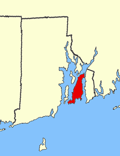
Aquidneck Island, officially Rhode Island, is an island in Narragansett Bay and in the State of Rhode Island and Providence Plantations, which is partially named after the island. The total land area is 97.9 km2 (37.8 sq mi), which makes it the largest island in the bay. The 2000 United States Census reported its population as 60,870.
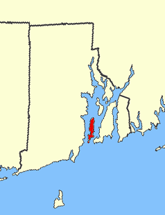
Conanicut Island is the second largest island in Narragansett Bay in the US state of Rhode Island. It is connected on the east by the Claiborne Pell Bridge to Newport on Aquidneck Island, and on the west by the Jamestown-Verrazano Bridge to North Kingstown on the mainland. The island comprises the town of Jamestown, Rhode Island. The United States Census Bureau reported a land area of 24.46 km2 (9.44 sq mi) and a population of 5,622 as of the 2000 census.
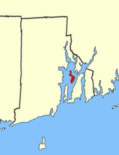
Prudence Island is the third-largest island in Narragansett Bay in the state of Rhode Island and part of the town of Portsmouth, Rhode Island. It is located near the geographical center of the bay. It is defined by the United States Census Bureau as Block Group 3, Census Tract 401.03 of Newport County, Rhode Island. As of the 2000 census, the population was 88 people living on a land area of 14.43 km².

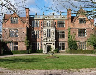
Hammersmith Farm is a Victorian mansion and estate located at 225 Harrison Avenue in Newport, Rhode Island, United States. It was the childhood home of First Lady Jacqueline Bouvier Kennedy, and the site of the reception for her 1953 wedding to U.S. Senator John F. Kennedy. During his presidency, it was referred to as the "Summer White House".

Prescott Farm is a historic preservation of a colonial farm in Middletown, Rhode Island. It spans 40 acres, and was in danger of demolition before Doris Duke, through the Newport Restoration Foundation bought it in 1973 and began restoration of the historical site. Notable features of it include an operational windmill, British General Prescott's Guard House, a county store, and a University of Rhode Island Master Gardener project with the purpose of simulating a historical vegetable garden through careful research on what crops where grown during that time period. The farm itself is typical of the farms on Aquidneck Island.
Ann Smith Franklin was an American colonial newspaper printer and publisher. She inherited the business from her husband, James Franklin, brother of Benjamin Franklin. She published the Newport, Rhode Island Mercury, printed an almanac series, and printed Rhode Island paper currency. She was the country’s first female newspaper editor, the first woman to write an almanac, and the first woman inducted into the University of Rhode Island's Journalism Hall of Fame.

Mason's Island is an inhabited island at the mouth of the Mystic River, in Stonington, Connecticut. The island was named after Major John Mason who was granted the island in recognition for his military services in the 1637 Pequot War in nearby Mystic. This island remained in the Mason family for over 250 years, from 1651 to 1913. Since then the Allyn family have been stewards of it, and most of the island is owned by the Mason's Island Company and regulated by property deeds under the Mason's Island Property Owners Association. The Mason's Island Marina and the Mystic River Marina are located on the north end of the island. Mason's Island is connected to the mainland by a causeway.

The Rhode Island Supreme Court is the court of last resort in the U.S. State of Rhode Island and Providence Plantations. The Court consists of a Chief Justice and four Associate Justices, all selected by the Governor of Rhode Island from candidates vetted by the Judicial Nominating Commission. Each justice enjoys lifetime tenure and no mandatory retirement age, similar to Federal judges. Justices may be removed only if impeached for improper conduct by a vote of the Rhode Island House of Representatives and convicted by trial in the Rhode Island Senate.
Greene Island is a small island in Narragansett Bay, Warwick, Rhode Island. The island was named after Captain John Greene who purchased the island in 1642 from Native Americans as part of a larger purchase of 660 acres around Occupaspatuxet Cove. Occupaspatuxet means where “meadows cut through by a river,” and the area was also known as Greene's Hold. Chief Miantonomi was one of the Indian witnesses on the deed to Greene, which referenced the "little island." The Greenes were followers of Samuel Gorton, a radical Christian philosopher and theologian, who sought refuge in the Warwick area. Greene Island features shallow tidal flats and marsh grasses.

Rose Island is an 18.5-acre (7.5 ha) island in Narragansett Bay off Newport, Rhode Island, United States. It is allegedly named "Rose Island" because at low tide the island appears to be shaped like a rose. The Island is only accessible by boat. The island and its lighthouse are run by the private, non-profit Rose Island Lighthouse Foundation.

The Battle of Rhode Island Site is the partially preserved location of the Battle of Rhode Island, fought August 29, 1778 during the American Revolutionary War. The battle took place in the town of Portsmouth, Rhode Island, located on Aquidneck Island north of Newport, and was the only major action of the war that took place in Rhode Island. It was also significant as the only battle of the war in which an entirely segregated unit of African-American soldiers fought. At the time of the action, the 1st Rhode Island Regiment consisted of companies of locally recruited African Americans with white officers. The two main areas associated with the battle were designated a National Historic Landmark in 1974.

The Point is one of the oldest neighborhoods in Newport, Rhode Island and has one of the highest concentrations of colonial houses in the United States. The neighborhood sits between Washington Street and Farewell Street/America's Cup in Newport looking out on Goat Island, former home to the U.S. Naval Torpedo Station.

Newport Art Museum, founded in 1912, is located on 76 Bellevue Avenue in Newport, Rhode Island. The museum operates a gallery in the John N. A. Griswold House, a National Historic Landmark that is the premier American Stick Style building.
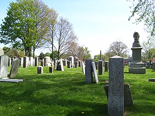
The Common Burying Ground and Island Cemetery are a pair of separate cemeteries on Farewell and Warner Street in Newport, Rhode Island. Together they contain over 5,000 graves, including a colonial-era slave cemetery and Jewish graves. The pair of cemeteries was added to the National Register of Historic Places as a single listing in 1974.

Arnold Burying Ground is a historic cemetery on Pelham Street just east of Spring Street in Newport, Rhode Island. It is the burial place of Benedict Arnold, Rhode Island's first governor under the Royal Charter of 1663.
Interstate 895 was a proposed Interstate Highway in Rhode Island and Massachusetts that would have supplemented Interstate 295 to create a full beltway around Providence.

The Coddington Cemetery is an early colonial cemetery located in Newport, Rhode Island, USA. It is sometimes called the Friends' Burial Ground, and has more colonial governors buried in it than any other cemetery in the state.

The United Baptist Church, John Clarke Memorial is a historic Baptist church in Newport, Rhode Island, USA that was founded in 1638-1644. It is one of the two oldest Baptist congregations in the United States and is currently affiliated with the American Baptist Church. The current meeting house of the church was constructed in 1846.


