
Death Valley National Park is a national park of the United States that straddles the California–Nevada border, east of the Sierra Nevada. The park boundaries include Death Valley, the northern section of Panamint Valley, the southern section of Eureka Valley and most of Saline Valley.

Death Valley is a desert valley in Eastern California, in the northern Mojave Desert, bordering the Great Basin Desert. It is thought to be the hottest place on Earth during summer.

The Amargosa River is an intermittent waterway, 185 miles (298 km) long, in southern Nevada and eastern California in the United States. The Amargosa River is one out of two rivers located in the California portion of the Mojave Desert with perennial flow. It drains a high desert region, the Amargosa Valley in the Amargosa Desert northwest of Las Vegas, into the Mojave Desert, and finally into Death Valley where it disappears into the ground aquifer. Except for a small portion of its route in the Amargosa Canyon in California and a small portion at Beatty, Nevada, the river flows above ground only after a rare rainstorm washes the region. A 26-mile (42 km) stretch of the river between Shoshone and Dumont Dunes is protected as a National Wild and Scenic River. At the south end of Tecopa Valley the Amargosa River Natural Area protects the habitat.

The California Trail was an emigrant trail of about 1,600 mi (2,600 km) across the western half of the North American continent from Missouri River towns to what is now the state of California. After it was established, the first half of the California Trail followed the same corridor of networked river valley trails as the Oregon Trail and the Mormon Trail, namely the valleys of the Platte, North Platte, and Sweetwater rivers to Wyoming. The trail has several splits and cutoffs for alternative routes around major landforms and to different destinations, with a combined length of over 5,000 mi (8,000 km).
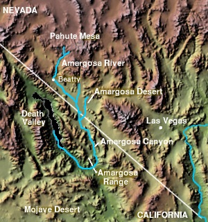
The Amargosa Valley is the valley through which the Amargosa River flows south, in Nye County, southwestern Nevada and Inyo County in the state of California. The south end is alternately called the "Amargosa River Valley'" or the "Tecopa Valley." Its northernmost point is around Beatty, Nevada and southernmost is Tecopa, California, where the Amargosa River enters into the Amargosa Canyon.
The exposed geology of the Death Valley area presents a diverse and complex set of at least 23 formations of sedimentary units, two major gaps in the geologic record called unconformities, and at least one distinct set of related formations geologists call a group. The oldest rocks in the area that now includes Death Valley National Park are extensively metamorphosed by intense heat and pressure and are at least 1700 million years old. These rocks were intruded by a mass of granite 1400 Ma and later uplifted and exposed to nearly 500 million years of erosion.

The Hastings Cutoff was an alternative route for westward emigrants to travel to California, as proposed by Lansford Hastings in The Emigrant's Guide to Oregon and California. The ill-fated Donner Party infamously took the route in 1846.

The Old Spanish Trail is a historical trade route that connected the northern New Mexico settlements of Santa Fe, New Mexico with those of Los Angeles, California and southern California. Approximately 700 mi (1,100 km) long, the trail ran through areas of high mountains, arid deserts, and deep canyons. It is considered one of the most arduous of all trade routes ever established in the United States. Explored, in part, by Spanish explorers as early as the late 16th century, the trail was extensively used by traders with pack trains from about 1830 until the mid-1850s. The area was part of Mexico from Mexican independence in 1821 to the Mexican Cession to the United States in 1848.

The Death Valley '49ers were a group of pioneers from the Eastern United States that endured a long and difficult journey during the late 1840s California Gold Rush to prospect in the Sutter's Fort area of the Central Valley and Sierra Nevada in California. Their route from Utah went through the Great Basin Desert in Nevada, and Death Valley and the Mojave Desert in Southern California, in attempting to reach the Gold Country.

Freeman Junction, a ghost town in Kern County, California, USA, was first homesteaded in the early 1870s. Freeman S. Raymond built a stage coach station here to accommodate travelers between the desert mines and Los Angeles. A group of Native Americans who were defending their homes and families in 1909 killed off the homesteaders and burned the stage station, after which the property lay dormant for several years. It was re-homesteaded in the 1920s by Clare C. Miley, who was born in 1900, and his wife. By the 1930s their small stone cabin became a gas station/car repair and later, a restaurant and some mining activities dominated the site. In 1953 a post office was planned, but never materialized and residents had to travel seven miles to Inyokern to collect their mail. By June, 1978, the town had died once again and the remains of the town have since been removed by passersby. Today, the site has reverted to its natural state and nothing remains.
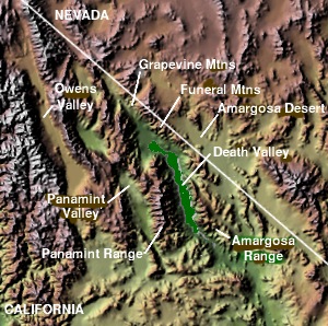
The Panamint Valley is a long basin located east of the Argus and Slate ranges, and west of the Panamint Range in the northeastern reach of the Mojave Desert, in eastern California, United States.
Caleb Greenwood was a Western U.S. fur trapper and trail guide.

William Lewis Manly was an American pioneer of the mid-19th century. He was first a fur hunter, a guide of westward bound caravans, a seeker of gold, and then a farmer and writer in his later years.
In the history of the American frontier, pioneers built overland trails throughout the 19th century, especially between 1840 and 1847 as an alternative to sea and railroad transport. These immigrants began to settle much of North America west of the Great Plains as part of the mass overland migrations of the mid-19th century. Settlers emigrating from the eastern United States did so with various motives, among them religious persecution and economic incentives, to move from their homes to destinations further west via routes such as the Oregon, California, and Mormon Trails. After the end of the Mexican–American War in 1849, vast new American conquests again encouraged mass immigration. Legislation like the Donation Land Claim Act and significant events like the California Gold Rush further encouraged settlers to travel overland to the west.
John Goller was an American pioneer and the first blacksmith in Los Angeles, California. He owned a blacksmith and carriage-making business and was a member of the governing body of Los Angeles as well as a founder of the city's first gas company.

Lake Manly was a pluvial lake in Death Valley, California. It forms occasionally in Badwater Basin after heavy rainfall, but at its maximum extent during the so-called "Blackwelder stand," ending approximately 120,000 years before present, the lake covered much of Death Valley with a surface area of 1,600 square kilometres (620 sq mi). Water levels varied through its history, and the chronology is further complicated by active tectonic processes that have modified the elevations of the various shorelines of Lake Manly; during the Blackwelder stage they reached 47–90 metres (154–295 ft) above sea level. The lake received water mainly from the Amargosa River and at various points from the Mojave River and Owens River. The lake and its substantial catchment favoured the spread of a number of aquatic species, including some lizards, pupfish and springsnails. The lake probably supported a substantial ecosystem, and a number of diatoms developed there.

Lake Panamint is a former lake that occupied Panamint Valley in California during the Pleistocene. It was formed mainly by water overflowing through the Owens River and which passed through Lake Searles into the Panamint Valley. At times, Lake Panamint itself overflowed into Death Valley and Lake Manly.

The Harry Wade Exit Route was discovered and made by Harry Wade from Illinois in 1849. Harry Wade, his wife and children were in the Bennett-Arcan party caravan emigrating west. At the direction of guide Jefferson Hunt the caravan took a poorly planned turn and descended into Death Valley, California while looking for a shortcut off the Old Spanish Trail. The caravan of a 100 wagons were looking for the shortcut to get to the California Gold Rush sooner. Several in the group died while there, affording the valley its namesake. Harry Wade found a path out of the Valley, the trail he made is today called the Harry Wade Road, a dirt road. After departing Death Valley Wade found the Old Spanish Trail and came to Southern California though the Cajon Pass. Many in the party also suffered but nonetheless made it out of Death Valley. Harry Wade Exit Route was designated a California Historic Landmark (No.622) on October 9, 1957. A marker was placed about 30 miles north of Baker, California, on the Harry Wade Exit Route, to designate where his family escaped. The marker is at the southern end of Death Valley National Park.

Bennett-Arcane Long Camp was a 1849er camp set up in December 1849 in Death Valley as they traveled to the California Gold Rush. They were emigrants crossing the harsh desert to get to California. The camp was located just west of valley's Badwater Basin in present-day Death Valley National Park. Badwater Basin is lowest point in North America and the United States, at a depth of 282 ft (86 m) below sea level. The Bennett-Arcane party became known as the Death Valley '49ers. The Death Valley '49ers were pioneers from the Eastern United States travelling west to prospect in the Sutter's Fort area of the Central Valley and Sierra Nevada in California. The wagon train crossed Utah across the Great Basin Desert in Nevada. They made a wrong turn on got trapped in Death Valley. After exiting they crossed the Mojave Desert into Southern California. Still wanting to go to the California Gold Country, the group used the southern Desert part of the Old Spanish Trail, after hearing about the death of the Donner Party. Allegedly, the Bennett-Arcane group coined the name Death Valley.

Rogers Peak is a 9,991-foot-elevation (3,045-meter) summit in Inyo County, California, United States.