Related Research Articles

Texas County is a county located in the panhandle of the U.S. state of Oklahoma. Its county seat is Guymon. As of the 2010 census, the population was 20,640. It is the second-largest county in the state, based on land area, and is named for Texas, the state that adjoins the county to its south. Texas County comprises the Guymon, OK Micropolitan Statistical Area. The county economy is largely based on farming and cattle production. It is one of the top-producing counties in the U.S. for wheat, cattle, and hogs. It also lies within the noted Hugoton-Panhandle natural gas field.

Harper County is a county located in the U.S. state of Oklahoma. As of the 2010 census, the population was 3,685, making it the fourth-least populous county in Oklahoma. The county seat is Buffalo. It was created in 1907 from the northwestern part of Woodward County, and named for Oscar Green Harper, who was clerk of the Oklahoma Constitutional Convention.

Cimarron County is the westernmost county in the U.S. state of Oklahoma. Its county seat is Boise City. As of the 2010 census, its population was 2,475, making it the least-populous county in Oklahoma; and indeed, throughout most of its history, it has had both the smallest population and the lowest population density of any county in Oklahoma. Located in the Oklahoma Panhandle, Cimarron County contains the only community in the state (Kenton) that observes the Mountain Time Zone. Black Mesa, the highest point in the state, is in the northwest corner of the county. The Cimarron County community of Regnier has the distinction of being the driest spot in Oklahoma ranked by lowest annual average precipitation, at just 15.62 inches; but at the same time, Boise City is the snowiest location in Oklahoma ranked by highest annual average snowfall, at 31.6 inches.

Beaver County is a county located in the U.S. state of Oklahoma. As of the 2010 census, the population was 5,636. The county seat is Beaver. The name was given because of the presence of many beaver dams on the Beaver River, which runs through the area. It is located in the Oklahoma Panhandle.

Beaver is a town and county seat in Beaver County, Oklahoma, United States. The community is in the Oklahoma Panhandle. As of the 2010 census, the town population was 1,515, a 3.5 percent decrease from 1,570 at the 2000 census. The city is host to the annual World Cow Chip Throwing Championship. Held in April, "Cow Chip" brings attention from nearby cities with a parade, carnival, and cowchip throwing.
Guymon is a city and county seat of Texas County, in the Oklahoma Panhandle, United States. As of the 2020 census, the city population was 12,965, an increase of 13.3% from 11,442 in 2010, and represents more than half of the population of the county. Cattle feedlots, corporate pork farms, and natural gas production dominate its economy, with wind energy production and transmission recently diversifying landowners' farms.

Mobeetie is a city in northwestern Wheeler County, Texas, United States, located on Sweetwater Creek and State Highway 152. Its population was 101 at the 2010 census, six below the 2000 figure.

The Arkansas River is a major tributary of the Mississippi River. It generally flows to the east and southeast as it traverses the U.S. states of Colorado, Kansas, Oklahoma, and Arkansas. The river's source basin lies in the western United States in Colorado, specifically the Arkansas River Valley. The headwaters derive from the snowpack in the Sawatch and Mosquito mountain ranges. It flows east into the Midwest via Kansas, and finally into the South through Oklahoma and Arkansas.
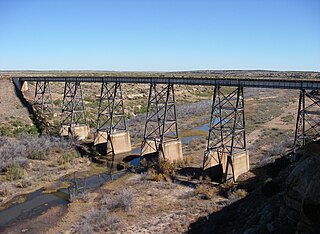
The Canadian River is the longest tributary of the Arkansas River in the United States. It is about 906 miles (1,458 km) long, starting in Colorado and traveling through New Mexico, the Texas Panhandle, and Oklahoma. The drainage area is about 47,700 square miles (124,000 km2).

The Cherokee Outlet, or Cherokee Strip, was located in what is now the state of Oklahoma in the United States. It was a 60-mile-wide (97 km) parcel of land south of the Oklahoma-Kansas border between 96 and 100°W. The Cherokee Outlet was created in 1836. The United States forced the Cherokee Nation of Indians to cede to the United States all lands east of the Mississippi River in exchange for a reservation and an "outlet" in Indian Territory. At the time of its creation, the Cherokee Outlet was about 225 miles (360 km) long. The cities of Enid, Woodward, Ponca City, and Perry were later founded within the boundaries of what had been the Cherokee Outlet.
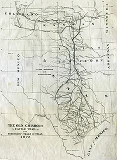
The Chisholm Trail was a trail used in the post-Civil War era to drive cattle overland from ranches in Texas to Kansas railheads. The trail was established by Black Beaver, a Lenape guide and rancher, and his friend Jesse Chisholm, a merchant. They collected and drove numerous cattle along the trail to Kansas, where they could be shipped east to achieve higher prices. The southern terminus was Red River Station, a trading post near the Red River along the northern border of Texas. The northern terminus was a trading post near Kansas City, Kansas. Chisholm owned both of these posts. In the years of the cattle drives, cowboys would drive large herds from ranches across Texas to the Red River Station and then north to Kansas City.

The Oklahoma Panhandle is the extreme northwestern region of the U.S. state of Oklahoma, consisting of Cimarron County, Texas County and Beaver County, from west to east. As with other salients in the United States, its name comes from the similarity of its shape to the handle of a pan.

The Cimarron River extends 698 miles (1,123 km) across New Mexico, Oklahoma, Colorado, and Kansas. The headwaters flow from Johnson Mesa west of Folsom in northeastern New Mexico. Much of the river's length lies in Oklahoma, where it either borders or passes through eleven counties. There are no major cities along its route. The river enters the Oklahoma Panhandle near Kenton, Oklahoma, crosses the southeastern corner of Colorado into Kansas, reenters the Oklahoma Panhandle, reenters Kansas, and finally returns to Oklahoma where it joins the Arkansas River at Keystone Reservoir west of Tulsa, Oklahoma, its only impoundment. The Cimarron drains a basin that encompasses about 18,927 square miles (49,020 km2).
The term Cross Timbers, also known as Ecoregion 29, Central Oklahoma/Texas Plains, is used to describe a strip of land in the United States that runs from southeastern Kansas across Central Oklahoma to Central Texas. Made up of a mix of prairie, savanna, and woodland, it forms part of the boundary between the more heavily forested eastern country and the almost treeless Great Plains, and also marks the western habitat limit of many mammals and insects.
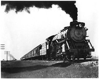
The Fort Worth and Denver Railway, nicknamed "the Denver Road", was a class I American railroad company that operated in the northern part of Texas from 1881 to 1982, and had a profound influence on the early settlement and economic development of the region.

Cattle drives were a major economic activity in the 19th and early 20th century American West, particularly between 1850s and 1910s. In this period, 27 million cattle were driven from Texas to railheads in Kansas, for shipment to stockyards in Louisiana and points east. The long distances covered, the need for periodic rests by riders and animals, and the establishment of railheads led to the development of "cow towns" across the frontier.

The Great Western Cattle Trail was used during the late 19th century for movement of cattle and horses to markets in eastern and northern states. It is also known as the Western Trail, Fort Griffin Trail, Dodge City Trail, Northern Trail and Texas Trail. It replaced the Chisholm trail when that closed. While it wasn't as well known, it was greater in length, reaching railheads up in Kansas and Nebraska and carried longhorns and horses to stock open-range ranches in the Dakotas, Wyoming, Montana, and two provinces in Canada. It took almost one hundred days to reach their destination.

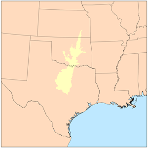
Northwestern Oklahoma is the geographical region of the state of Oklahoma which includes the Oklahoma Panhandle and a majority of the Cherokee Outlet, stretching to an eastern extent along Interstate 35, and its southern extent along the Canadian River to Noble County. Northwest Oklahoma is also known by its Oklahoma Department of Tourism designation, Red Carpet Country, which is named after the region's red soil and alludes to the metaphor that the panhandle is a "red carpet" into Oklahoma. The region consists of Cimarron, Texas, Beaver, Harper, Woods, Alfalfa, Grant, Kay, Ellis, Woodward, Major, Garfield, Noble, Dewey, Blaine, and Kingfisher counties.

The Anchor D Ranch in Guymon, Oklahoma was one of the largest cattle ranches in the No Man's Land section of the Oklahoma/Texas Panhandle area. It was created around 1878 by Ezra Dudley, an investor from Newton, Massachusetts and his son, John. The ranch was headquartered on the Beaver River, in what is now Texas County, Oklahoma. After buying his first herd of cattle in south Texas, he hired experienced cowboys to drive them to the ranch. He continued to add more cattle, until he eventually he was feeding around thirty thousand cattle on an estimated 960,000 acres (1,500 sq mi).

Black Beaver or Se-ket-tu-may-qua was a trapper and interpreter who worked for the American Fur Company. He served as a scout and guide as he was fluent in English, as well as several European and Native American languages. He is credited with establishing the California and Chisholm trails.
References
- 1 2 "Jones and Plummer Trail". C. Robert Haywood, Encyclopedia of Oklahoma History and Culture. Retrieved October 21, 2020.
- ↑ Rathjen, Frederick W. (1998). Texas Panhandle Frontier. Texas Tech University Press. p. 132. ISBN 0-89672-399-2.
- ↑ Maddux, Vernon R. (2003). In Dull Knife's Wake: The True Story of the Northern Cheyenne Exodus of 1878. Horse Creek Publications. p. 54. ISBN 0-9722217-1-9.
- ↑ "Beaver". V. Pauline Hodges, Encyclopedia of Oklahoma History and Culture. Retrieved October 21, 2020.