
In topography, jut is a measure of the base-to-peak rise of a mountain summit or other landform. It describes how sharply a location rises above surrounding terrain by factoring both height above surroundings and steepness of ascent. [1]
In topography, jut is a measure of the base-to-peak rise of a mountain summit or other landform. It describes how sharply a location rises above surrounding terrain by factoring both height above surroundings and steepness of ascent. [1]
A mountain with a jut of X can be interpreted to rise as sharply or impressively as a vertical cliff of X. For example, a vertical cliff of height 100 meters, a 45° slope of height 141 meters, and a 30° slope of height 200 meters all measure a jut of 100 meters and can be interpreted to rise equally sharply. Jut can be further decomposed into base-to-peak height and base-to-peak steepness, where jut equals base-to-peak height multiplied by the sine of base-to-peak steepness.
Jut is the maximum angle-reduced height (symbol H'), which can be defined as the vector projection, in the line of sight, of the peak's height (or vertical separation), H: [2] [3]
where e is the summit's elevation angle. Height, angle-reduced height, and jut have unit of length (meter or feet). While height and angle-reduced height depend on the viewing location around the peak, jut is a constant value for a given peak. [1] Base is the location where angle-reduced height is maximized.
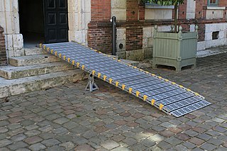
An inclined plane, also known as a ramp, is a flat supporting surface tilted at an angle from the vertical direction, with one end higher than the other, used as an aid for raising or lowering a load. The inclined plane is one of the six classical simple machines defined by Renaissance scientists. Inclined planes are used to move heavy loads over vertical obstacles. Examples vary from a ramp used to load goods into a truck, to a person walking up a pedestrian ramp, to an automobile or railroad train climbing a grade.

In geography and geology, a cliff or rock face is an area of rock which has a general angle defined by the vertical, or nearly vertical. Cliffs are formed by the processes of weathering and erosion, with the effect of gravity. Cliffs are common on coasts, in mountainous areas, escarpments and along rivers. Cliffs are usually composed of rock that is resistant to weathering and erosion. The sedimentary rocks that are most likely to form cliffs include sandstone, limestone, chalk, and dolomite. Igneous rocks such as granite and basalt also often form cliffs.

A trajectory or flight path is the path that an object with mass in motion follows through space as a function of time. In classical mechanics, a trajectory is defined by Hamiltonian mechanics via canonical coordinates; hence, a complete trajectory is defined by position and momentum, simultaneously.

Mount Whitney is the highest mountain in the contiguous United States, with an elevation of 14,505 feet (4,421.2 m). It is in East–Central California, in the Sierra Nevada, on the boundary between California's Inyo and Tulare counties, and 84.6 miles (136.2 km) west-northwest of North America's lowest topographic point, Badwater Basin in Death Valley National Park, at 282 ft (86 m) below sea level. The mountain's west slope is in Sequoia National Park and the summit is the southern terminus of the John Muir Trail, which runs 211.9 mi (341.0 km) from Happy Isles in Yosemite Valley. The eastern slopes are in Inyo National Forest in Inyo County. Mount Whitney is ranked 18th by topographic isolation.

The grade (US) or gradient (UK) of a physical feature, landform or constructed line refers to the tangent of the angle of that surface to the horizontal. It is a special case of the slope, where zero indicates horizontality. A larger number indicates higher or steeper degree of "tilt". Often slope is calculated as a ratio of "rise" to "run", or as a fraction in which run is the horizontal distance and rise is the vertical distance.
Projectile motion is a form of motion experienced by an object or particle that is projected in a gravitational field, such as from Earth's surface, and moves along a curved path under the action of gravity only. In the particular case of projectile motion on Earth, most calculations assume the effects of air resistance are passive.

Mount Stuart is a mountain in the Cascade Range, in the U.S. state of Washington. It is the second highest non-volcanic peak in the state, after Bonanza Peak and seventh-highest overall. Mount Stuart is the highest peak in the Stuart Range, and it is located in the central part of the Washington Cascades, south of Stevens Pass and east of Snoqualmie Pass in the Alpine Lakes Wilderness.

Hunter Mountain is in the towns of Hunter and Lexington, just south of the village of Hunter, in Greene County, New York, United States. At approximately 4,040 feet (1,231 m) in elevation, it is the highest peak in the county and the second-highest peak in the Catskill Mountains.

Telescope Peak is the highest point within Death Valley National Park, in the U.S. state of California. It is also the highest point of the Panamint Range, and lies in Inyo County. From atop this desert mountain one can see for over one hundred miles in many directions, including west to Mount Whitney, and east to Charleston Peak. The mountain was named for the great distance visible from the summit.

Notch Peak is a distinctive summit located on Sawtooth Mountain in the House Range, west of Delta, Utah, United States. The peak and the surrounding area are part of the Notch Peak Wilderness Study Area (WSA). Bristlecone pines, estimated to be 3,000 to 4,000 years old, are located on the ridges surrounding Notch Peak.

Kaaterskill High Peak is one of the Catskill Mountains, located in the Town of Hunter in Greene County, New York, United States. It was once believed to be the highest peak in the entire range, but its summit, at 3,655 feet (1,114 m) in elevation, places it only 23rd among the Catskill High Peaks. It is, however, the fourth most prominent peak in the range. Due to its situation as the easternmost High Peak, its summit is just outside the watersheds of New York City's reservoirs in the region.

Pigeon Peak, elevation 13,978 ft (4,260 m), is a summit in the Needle Mountains, a subrange of the San Juan Mountains in the southwestern part of the US State of Colorado. It rises dramatically on the east side of the Animas River, 1.5 miles (2.4 km) west of the fourteener Mount Eolus. It is located in the Weminuche Wilderness, part of the San Juan National Forest.

Mount Hood, also known as Hood Mountain, is a mountain near the southeastern edge of Santa Rosa, California, at the northeast of the Sonoma Valley and attains a height of 2,733 feet (833 m). The original name was Mount Wilikos, an Indian name meaning "willows." Most of the drainage from Mount Hood contributes to the headwaters of Sonoma Creek. A prominent feature is the extensive rock face visible on the upper half of the mountain as viewed from State Route 12. The habitats on the mountain include mixed oak forest, pygmy forest, chaparral and riparian zones. In prehistoric times the slopes of Mount Hood were inhabited by a division of the Yuki tribe. Most of Mount Hood is within the Hood Mountain Regional Park maintained by Sonoma County. Mount Hood is part of the inner coast Mayacamas Range, and lies mostly within Sonoma County, with a part of the mountain geographically within Napa County. Mount Hood affords overlooks of the Pacific Ocean, San Francisco Bay and "a spectacular view east to the Sierra Nevada Range."

Rusk Mountain is a peak located in the towns of Jewett and Lexington in Greene County, New York, United States. At 3,680 feet (1,120 m) in elevation, it is the 20th-highest peak in the Catskill Mountains and considered a member of the Catskill High Peaks. While there is no maintained trail, a bushwhack to the summit is considered relatively easy, and required for membership in the Catskill Mountain 3500 Club.
Panther Mountain is one of the Catskill High Peaks, located in the Town of Shandaken in Ulster County, New York. At approximately 3,720 feet (1,130 m) in elevation, it is the 18th highest in the range. A combination of factors has led some geologists to believe the mountain is on the site of an ancient meteorite impact crater.

The Black Buttes, also known historically as the Sawtooth Rocks, make up an extinct stratovolcano in the Cascade Volcanic Arc in Whatcom County, Washington, United States. Glacially eroded remnants of this volcano rise above the Deming Glacier, part of the glacier system of the nearby volcano, Mount Baker. There are three major peaks — Colfax, Lincoln, and Seward — all of which can be climbed.

Mount Baldy is an extinct stratovolcano in eastern Arizona in the United States. With a summit elevation of 11,409 feet (3,477 m), the peak of Mount Baldy rises above the tree line and is left largely bare of vegetation, lending the mountain its current name. The Mount Baldy Wilderness occupies the eastern slope of the mountain and is managed by the Apache-Sitgreaves National Forest.

Graham Mountain is the seventh highest of the Catskill High Peaks and the highest privately owned mountain in the range. It is located in the town of Hardenburgh, New York, United States.
Tule Peak is a summit located in the northwest part of the state of Nevada, United States in the county region of Washoe. It is the highest peak in the Virginia Mountains with a height of 2659.7m.
Haystack Peak is a 12,020-foot elevation (3,664 m) mountain summit located in Juab County, Utah, United States.

