Related Research Articles

The Black Sea is a marginal sea of the Atlantic Ocean lying between Europe and Asia; east of the Balkans, south of the East European Plain in Eastern Europe, west of the Caucasus, and north of Anatolia in Western Asia. It is supplied by major rivers, principally the Danube, Dnieper, and Don. The watersheds of many countries drain into the sea beyond the six that share its coast.

The Balkans, also known as the Balkan Peninsula, are a geographic area in southeastern Europe with various definitions and meanings, including geopolitical and historical. The region takes its name from the Balkan Mountains that stretch throughout the whole of Bulgaria. The Balkan Peninsula is bordered by the Adriatic Sea in the northwest, the Ionian Sea in the southwest, the Aegean Sea in the south, the Turkish Straits in the east, and the Black Sea in the northeast. The northern border of the peninsula is variously defined. The highest point of the Balkans is Mount Musala, 2,925 metres (9,596 ft), in the Rila mountain range, Bulgaria.

The Dardanelles, also known as Strait of Gallipoli from Gallipoli Peninsula or from Classical Antiquity as the Hellespont (; Classical Greek: Ἑλλήσποντος, romanized: Hellēspontos, lit. 'Sea of Helle'), is a narrow, natural strait and internationally significant waterway in northwestern Turkey that forms part of the continental boundary between Europe and Asia, and separates Asian Turkey from European Turkey. One of the world's narrowest straits used for international navigation, the Dardanelles connects the Sea of Marmara with the Aegean and Mediterranean Seas, while also allowing passage to the Black Sea by extension via the Bosphorus. The Dardanelles is 61 kilometres (38 mi) long, and 1.2 to 6 kilometres wide, averaging 55 metres (180 ft) deep with a maximum depth of 103 metres (338 ft) at its narrowest point abreast the city of Çanakkale.

This article is about telecommunications systems in Armenia.

Constanța, historically known as Tomis, is the oldest continuously inhabited city in Romania. It was founded around 600 BC. The city is located in the Northern Dobruja region of Romania, on the Black Sea coast. It is the capital of Constanța County and the largest city in the historical region of Dobruja.
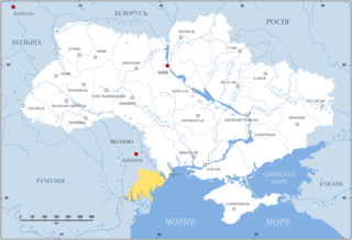
Budjak or Budzhak, historically known as Bessarabia until 1812, is a historical region in Ukraine and Moldova. Lying along the Black Sea between the Danube and Dniester rivers, this sparsely populated multi-ethnic 600,000-people region of 13,188 km2 is located in the southern part of historical Bessarabia. Nowadays, the larger part of the region is included in Ukraine's Odessa Oblast, while the rest is included in the southern districts of Moldova. The region is bordered to the north by the rest of Moldova, to the west and south by Romania, and to the east by the Black Sea and the rest of Ukraine.

Nikopol is a town in northern Bulgaria, the administrative center of Nikopol Municipality, part of Pleven Province, on the right bank of the Danube river, 4 kilometres downstream from the mouth of the Osam river. It spreads at the foot of steep chalk cliffs along the Danube and up a narrow valley. As of December 2009, the town has a population of 3,892 inhabitants.

Balchik is a Black Sea coastal town and a seaside resort in the Southern Dobruja area of northeastern Bulgaria. It is located in Dobrich Province, 35 km southeast of Dobrich and 42 km northeast of Varna. The town sprawls scenically along hilly terraces descending from the Dobruja plateau to the sea. It is often called "The white city" because of the white color of the hills.

The Bulgarian Black Sea Coast, also known as the Bulgarian Riviera, covers the entire eastern bound of Bulgaria stretching from the Romanian Black Sea resorts in the north to European Turkey in the south, along 378 km of coastline. White and golden sandy beaches occupy approximately 130 km of the 378 km long coast. The region is an important center of tourism during the summer season (May–October), drawing millions of foreign and local tourists alike and constituting one of the country's most popular tourist destinations. Prior to 1989 the Bulgarian Black Sea coast was internationally known as the Red Riviera. Since the fall of the Iron Curtain, however, its nickname has been changed to the Bulgarian Riviera.
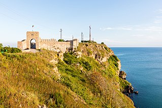
Kaliakra is a long and narrow headland in the Southern Dobruja region of the northern Bulgarian Black Sea Coast, 12 kilometres (7 mi) east of Kavarna, 60 kilometres (37 mi) northeast of Varna and 65 kilometres (40 mi) southwest of Mangalia. The coast is steep with vertical cliffs reaching 70 metres (230 ft) down to the sea. Kaliakra is a nature reserve, where dolphins and cormorants can be observed. It sits on the Via Pontica, a major bird migration route from Africa into Eastern and Northern Europe. Many rare and migrant birds can be seen here in spring and autumn and, like much of this coastline, is home to several rare breeding birds. The rest of the reserve also has unusual breeding birds; saker falcon, lesser grey shrike and a host of others.

The Black Sea Fiber-Optic Cable System (BSFOCS) is a 1,300 km (808 mi) submarine telecommunications cable system linking three countries bordering the Black Sea. It went into operation in September 2001, and has a total capacity of 20 Gbit/s along 2 fiber pairs.

ITUR or Italy - Turkey - Ukraine - Russia is a submarine telecommunications cable system linking the aforementioned countries.

European route E 87 is part of the United Nations international E-road network. It is an important north–south road on the coast of Black Sea, running from Odessa (Ukraine), Tulcea (Romania), Constanţa (Romania), Varna (Bulgaria) south through Burgas (Bulgaria) via Çanakkale to Antalya (Turkey).

The Danube is Europe's second-longest river after the Volga, flowing through much of Central and Southeastern Europe, from the Black Forest into the Black Sea. Its longest headstream Breg rises in Furtwangen im Schwarzwald, while the river carries its name from its source confluence in Donaueschingen onwards.
The CS Chamarel, originally CS Vercors was a cable layer owned by France Telecom Marine, laying submarine communications cables around the world. It was built in 1974 and destroyed by a fire in August 2012. As the Vercors, the ship laid cables on and between all continents except Antarctica, including numerous trans-Atlantic cables and the first ever Israeli-made cable, and set the record for the deepest submarine buried cable lay in 2000. The ship was badly damaged by a fire in August 2012.

The Black Sea trade and economy provide an integral part in the connection between Asia and Europe. In addition to sea ports and fishing, key activities include hydrocarbons exploration for oil and natural gas, and tourism. According to NATO, the Black sea is a strategic corridor that provides smuggling channels for moving legal and illegal goods including drugs, radioactive materials, and counterfeit goods that can be used to finance terrorism.
References
- https://web.archive.org/web/20070930122255/http://foptnet.ge/map2eng.htm Map of the cable system (3 Systems BSFOCS, KAFOS, & ITUR)