Kablovi

Last updated
Kablovi
Village
Bosnia and Herzegovina location map.svg
Red pog.svg
Kablovi
Coordinates: 44°40′N17°16′E / 44.667°N 17.267°E / 44.667; 17.267
Country Bosnia and Herzegovina
Entity Republika Srpska
Municipality Čelinac
Time zone CET (UTC+1)
  Summer (DST) CEST (UTC+2)

Kablovi (Cyrillic: Каблови) is a village in the municipality of Čelinac, Republika Srpska, Bosnia and Herzegovina. [1]

Village Small clustered human settlement smaller than a town

A village is a clustered human settlement or community, larger than a hamlet but smaller than a town, with a population ranging from a few hundred to a few thousand. Though villages are often located in rural areas, the term urban village is also applied to certain urban neighborhoods. Villages are normally permanent, with fixed dwellings; however, transient villages can occur. Further, the dwellings of a village are fairly close to one another, not scattered broadly over the landscape, as a dispersed settlement.

Municipalities of Republika Srpska

Under the "Law on Territorial Organization and Local Self-Government" adopted in 1994, Republika Srpska was divided into 80 municipalities. After the conclusion of the Dayton Peace Agreement, the law was amended in 1996 to reflect the changes to the entity's borders and now provides for the division of Republika Srpska into 64 municipalities.

Čelinac Town and municipality in Republika Srpska, Bosnia and Herzegovina

Čelinac is a town and municipality located in north-west Republika Srpska, an entity of Bosnia and Herzegovina. As of 2013, it has a population of 15,548 inhabitants.

Related Research Articles

Janja Place in Republika Srpska, Bosnia and Herzegovina

Janja is a town in the municipality of Bijeljina, Republika Srpska, Bosnia and Herzegovina. Janja is located in the Podrinje region of Bosnia and Herzegovina. Janja is famous for the rivers Janja and Drina. It is the only Bosniak community in the Municipality and consists of many displaced persons from other parts of Bosnia and Herzegovina.

Letka Village in Federation of Bosnia and Herzegovina, Bosnia and Herzegovina

Letka is a village in the municipality of Tomislavgrad, Bosnia and Herzegovina.

Zvirovići Village in Federation of Bosnia and Herzegovina, Bosnia and Herzegovina

Zvirovići is a village in Herzegovina, in Čapljina municipality, Federation of Bosnia and Herzegovina, Bosnia and Herzegovina.

Dazdarevo Village in Republika Srpska, Bosnia and Herzegovina

Dazdarevo is a village in the municipality of Bijeljina, Republika Srpska, Bosnia and Herzegovina.

Medeno Polje Village in Bosanski Petrovac, Bosnia and Herzegovina

Medeno Polje is a village in the municipality of Bosanski Petrovac, Bosnia and Herzegovina.

Vođenica Village in Bosanski Petrovac, Bosnia and Herzegovina

Vođenica is a village in the municipality of Bosanski Petrovac, Bosnia and Herzegovina.

Glogova, Bratunac Village in Republika Srpska, Bosnia and Herzegovina

Glogova is a village in the municipality of Bratunac, Bosnia and Herzegovina, where on 8 May 1992, in the early days of the Bosnian War (1992–95), 65 Bosnian Muslim civilians were killed in a massacre ordered by Miroslav Deronjić, President of the Bratunac Municipal Board of the Serbian Democratic Party (SDS) of Bosnia and Herzegovina.

Ćoseti Village in Brčko, Bosnia and Herzegovina

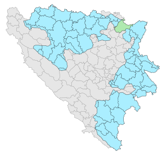
Ćoseti is a village in the municipality of Brčko, Bosnia and Herzegovina. A small village just outside Čande and Maoča which are also in the Brcko District. The population for Ćoseti is estimated around 150 or less. The village during the 1992-1995 war was not hit as hard as the surrounding cities of Brcko District. New government funding as been asked in order to create better roads and support the new school that was built back in 2009. There are a few people that are from the United States that live there due to them coming to America during the warfare starting in 1992.

Sutješćica Village in Breza, Bosnia and Herzegovina

Sutješćica is a village in the municipality of Breza, Bosnia and Herzegovina.

Mehovci Village in Republika Srpska, Bosnia and Herzegovina

Mehovci is a village in the municipality of Čelinac, Republika Srpska, Bosnia and Herzegovina.

Gornji Bogovići Village in Federation of Bosnia and Herzegovina, Bosnia and Herzegovina

Gornji Bogovići is a village in the municipality of Goražde, Bosnia and Herzegovina.

Podborje Village in Kakanj, Bosnia and Herzegovina

Podborje is a village in the municipality of Kakanj, Bosnia and Herzegovina.

Vinac Village in Federation of Bosnia and Herzegovina, Bosnia and Herzegovina

Vinac is a village in the municipality of Jajce, Bosnia and Herzegovina.

Mrnjići Village in Republika Srpska, Bosnia and Herzegovina

Mrnjići is a village in the municipality of Trebinje, Republika Srpska, Bosnia and Herzegovina.

Orašje Površ Village in Republika Srpska, Bosnia and Herzegovina

Orašje Površ is a village in the municipality of Trebinje, Republika Srpska, Bosnia and Herzegovina.

Gojakovići, Kladanj Village in Tuzla Canton, Bosnia and Herzegovina

Gojakovići is a village in the municipality of Kladanj, Bosnia and Herzegovina.

Kuge (Srebrenik) Village in Tuzla Canton, Bosnia and Herzegovina

Kuge is a village in Bosnia and Herzegovina. According to the 1991 census, the village is located in the municipality of Srebrenik.

Donja Lijeska Village in Republika Srpska, Bosnia and Herzegovina

Donja Lijeska is a village in the municipality of Višegrad, Bosnia and Herzegovina.

Krnjići Village in Srebrenica, Bosnia and Herzegovina

Krnjići is a village in the municipality of Srebrenica, Bosnia and Herzegovina.

Vukšić Gornji Village in Brčko, Bosnia and Herzegovina

Vukšić Gornji is a village in the municipality of Brčko, Bosnia and Herzegovina.

References

  1. Official results from the book: Ethnic composition of Bosnia-Herzegovina population, by municipalities and settlements, 1991. census, Zavod za statistiku Bosne i Hercegovine - Bilten no.234, Sarajevo 1991.

Coordinates: 44°40′N17°16′E / 44.667°N 17.267°E / 44.667; 17.267

Geographic coordinate system Coordinate system

A geographic coordinate system is a coordinate system that enables every location on Earth to be specified by a set of numbers, letters or symbols. The coordinates are often chosen such that one of the numbers represents a vertical position and two or three of the numbers represent a horizontal position; alternatively, a geographic position may be expressed in a combined three-dimensional Cartesian vector. A common choice of coordinates is latitude, longitude and elevation. To specify a location on a plane requires a map projection.