Kabul is the capital city of Afghanistan.
Contents
Kabul may also refer to:
Kabul is the capital city of Afghanistan.
Kabul may also refer to:

Jalalabad is the fifth-largest city of Afghanistan. It has a population of about 356,274, and serves as the capital of Nangarhar Province in the eastern part of the country, about 130 kilometres (80 mi) from the capital Kabul. Jalalabad is located at the junction of the Kabul River and the Kunar River in a plateau to the south of the Hindu Kush mountains. It is linked by the Kabul-Jalalabad Road to the west and Peshawar in Khyber Pakhtunkhwa, Pakistan, to the east through Torkham and the Khyber Pass.

Kabul is the capital city of Afghanistan. Located in the eastern half of the country, it is also a municipality, forming part of the Kabul Province. The city is divided for administration into 22 municipal districts. In 2023 its population was estimated to be 4.95 million people. In contemporary times, Kabul has served as Afghanistan's political, cultural and economical center. Rapid urbanisation has made it the country's primate city and the 75th-largest city in the world.

Kandahar is a city in Afghanistan, located in the south of the country on the Arghandab River, at an elevation of 1,010 m (3,310 ft). It is Afghanistan's second largest city after Kabul, with a population of about 614,118. It is the capital of Kandahar Province and the centre of the larger cultural region called Loy Kandahar.

Transport in Afghanistan is done mostly by road, rail and air. Much of the nation's road network was built in the mid-20th century but left to ruin during the last two decades of that century due to war and political turmoil. Officials of the current Islamic Emirate have continued to improve the national highways, roads, and bridges. In 2008, there were about 700,000 vehicles registered in Kabul. At least 1,314 traffic collisions were reported in 2022.

Gardez is the capital of the Paktia Province of Afghanistan. The population of the city was estimated to be ca. 10,000 in the 1979 census and was estimated to be 70,000 in 2008. The majority of the city's native population is Pashtun. The city of Gardez is located at the junction between two important roads that cut, through a huge alpine valley. Surrounded by the mountains and deserts of the Hindu Kush, which boil up from the valley floor to the north, east and west, it is the axis of commerce for a huge area of eastern Afghanistan and has been a strategic location for armies throughout the country's long history of conflict. Observation posts built by Alexander the Great are still crumbling on the hilltops just outside the city limits. The city of Gardez has a population of 70,641. It has 13 districts and a total land area of 6,174 hectares (23.84 sq mi). The total number of dwellings in this city is 7,849.

Kunduz is one of the 34 provinces of Afghanistan, located in the northern part of the country next to Tajikistan. The population of the province is around 1,136,677, which is mostly a tribal society; it is one of Afghanistan's most ethnically diverse provinces with many different ethnicities in large numbers living there. The city of Kunduz serves as the capital of the province. It borders the provinces of Takhar, Baghlan, Samangan and Balkh, as well as the Khatlon Region of Tajikistan. The Kunduz Airport is located next to the provincial capital.

Kabul, situated in the east of the country, is one of the thirty-four provinces of Afghanistan. The capital of the province is Kabul city, which is Afghanistan's capital and largest city. The population of the Kabul Province is over 5.5 million people as of 2022, of which over 85 percent live in urban areas. The current governor of the province is Qari Baryal.

Kapisa is the smallest of Afghanistan's thirty-four provinces and is located in the north-east of the country. It has an estimated population of 496,840 people and an area of 1,842 km2 (711 sq mi), making it the most densely populated province apart from Kabul Province. It borders Panjshir Province to the north, Laghman Province to the east, Kabul Province to the south and Parwan Province to the west. Mahmud-i-Raqi is the provincial capital, while the most populous city and district of Kapisa is Nijrab.

Logar is one of the 34 provinces of Afghanistan located in the eastern section of the country. It is divided into 7 districts and contains hundreds of villages. Puli Alam is the capital of the province. As of 2021, Logar has a population of approximately 442,037 people, most of whom are ethnic Pashtuns and Tajiks.

Parwan also spelled Parvan is one of the 34 provinces of Afghanistan. It is the largest province of the Greater Parwan region and has a population of about 751,000. The province is multi-ethnic and mostly rural society. The province is divided into ten districts. The town of Imam Abu Hanifa serves as the provincial capital. The province is located north of Kabul Province and south of Baghlan Province, west of Panjshir Province and Kapisa Province, and east of Maidan Wardak Province and Bamyan Province. The province's famous tourism attraction is the Golghondi Hill, also known as “the flower hill,” located in Imam Azam about an hour away from the capital city of Kabul. After Panjshir this province has been considered as one of the main raising points of Afghanistan War against Soviets.

Paghman (Dari/Pashto:پغمان) is a town in the hills near Afghanistan's capital of Kabul. It is the seat of the Paghman District which has a population of about 120,000, mainly Pashtuns and Tajiks. The gardens of Paghman are a major tourist attraction, and why the city is also known as the garden capital of Afghanistan. The neighboring town of Qargha is to the southeast, which can be reached by several roads.

The Kabul River, the classical Cophen, is a river that emerges in the Sanglakh Range of the Hindu Kush mountains in the northeastern part of Maidan Wardak Province, Afghanistan. It is separated from the watershed of the Helmand River by the Unai Pass. The Kabul River is a tributary of the Indus River, flowing into it near Attock, Pakistan. The Kabul is the main river in eastern Afghanistan and in the Khyber Pakhtunkhwa province of Pakistan.

Baghlan is a city in northern Afghanistan, in the eponymous province, Baghlan Province. It is located three miles east of the Kunduz River, 35 miles south of Khanabad, and about 500 metres above sea level in the northern Hindu Kush. Baghlan's capital, Pul-e-Khumri, is known to be an economic hub connected to eight other provinces by the Kabul-North highway.

Lashkargāh, historically called Bost or Boost, is a city in southwestern Afghanistan and the capital of Helmand Province. It is located in Lashkargah District, where the Arghandab River merges into the Helmand River. The city has a population of 201,546 as of 2006. Lashkargah is linked by major roads with Kandahar to the east, Zaranj on the border with Iran to the west, and Farah and Herat to the north-west. It is mostly very arid and desolate. However, farming does exist around the Helmand and Arghandab rivers. Bost Airport is located on the east bank of the Helmand River, five miles north of the junction of the Helmand and Arghandab rivers. Because of the trading hubs, it is Afghanistan's second largest city in size, after Kabul and before Kandahar.
Hissar means fort or castle in Arabic, with variants adopted into Persian and Turkish (hisar).

Chaghcharān, also called Firozkoh, is a town and district in central Afghanistan, which serves as the capital of Ghor Province. It is located on the southern side of the Hari River, at an altitude of 2,230 m above sea level. Chaghcharan is linked by a 380 kilometres (240 mi) long highway with Herat to the west, and a 450 kilometres (280 mi) long highway with Kabul to the east. The town has an airport called Chaghcharan Airport.
Qadesh, Qedesh, Qetesh, Kadesh, Kedesh, Kadeš and Qades come from the common Semitic root "Q-D-Š", which means "sacred."

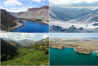
Tourism in Afghanistan is regulated by the Ministry of Information and Culture. There are at least 350 tourism companies operating in Afghanistan. Tourism was at its peak before the 1978 Saur Revolution, which was followed by the decades of warfare. Between 2013 and 2016, Afghan embassies issued between 15,000 and 20,000 tourist visas annually.

The Kabul–Jalalabad Road, also known as National Highway 08 (NH08), is a highway running between the Afghan cities of Kabul and Jalalabad, the largest city in eastern Afghanistan and capital of Nangarhar Province. A portion of the road runs through the Tang-e Gharu gorge.
The year 2021 in Afghanistan was marked by a major offensive from the Taliban beginning in May and the Taliban capturing Kabul in August.