Related Research Articles

Central Plaza is a 78-storey, 374 m (1,227 ft) skyscraper completed in August 1992 at 18 Harbour Road, in Wan Chai on Hong Kong Island in Hong Kong. It is the third tallest tower in the city after 2 International Finance Centre in Central and the ICC in West Kowloon. It was the tallest building in Asia from 1992 to 1996, until the Shun Hing Square was built in Shenzhen, a neighbouring city. Central Plaza surpassed the Bank of China Tower as the tallest building in Hong Kong until the completion of 2 IFC.

The Challenger Deep is the deepest known point of the seabed of Earth, located in the western Pacific Ocean at the southern end of the Mariana Trench, in the ocean territory of the Federated States of Micronesia. According to the GEBCO Gazetteer of Undersea Feature Names the depression's depth is 10,920 ± 10 m (35,827 ± 33 ft) at 11°22.4′N142°35.5′E, although its exact geodetic location remains inconclusive and its depth has been measured at 10,902–10,929 m (35,768–35,856 ft) by deep-diving submersibles, remotely operated underwater vehicles, benthic landers, and sonar bathymetry. The differences in depth estimates and their geodetic positions are scientifically explainable by the difficulty of researching such deep locations.

Aosta is the principal city of the Aosta Valley, a bilingual region in the Italian Alps, 110 km (68 mi) north-northwest of Turin. It is situated near the Italian entrance of the Mont Blanc Tunnel, at the confluence of the Buthier and the Dora Baltea, and at the junction of the Great and Little St Bernard Pass routes.

Broch of Mousa is a preserved Iron Age broch or round tower. It is on the island of Mousa in Shetland, Scotland. It is the tallest broch still standing and amongst the best-preserved prehistoric buildings in Europe. It is thought to have been constructed c. 300 BC, and is one of more than 500 brochs built in Scotland. The site is managed by Historic Environment Scotland as a scheduled monument.
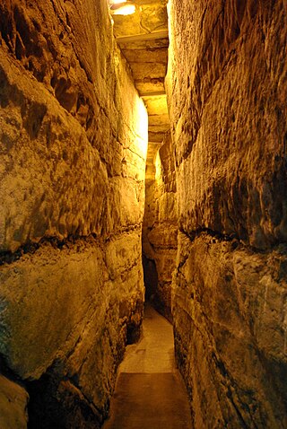
The Western Wall Tunnel is a tunnel exposing the Western Wall slightly north from where the traditional, open-air prayer site ends and up to the Wall's northern end. Most of the tunnel is in continuation of the open-air Western Wall and is located under buildings of the Muslim Quarter of the Old City of Jerusalem. While the open-air portion of the Western Wall is approximately 60 metres (200 ft) long, the majority of its original length of 488 metres (1,601 ft) is hidden underground. The tunnel allows access to the remainder of the Wall in a northerly direction.
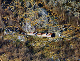
Me-Åkernes or Midtre Åkernes is a deserted fjord farm on the slopes of Åkerneset mountain along the northern shore of the Sunnylvsfjorden in Stranda Municipality in Møre og Romsdal county, Norway. It is located 13 kilometres (8 mi) northeast of the village of Hellesylt. The farm is located in the West Norwegian Fjords Norwegian World Heritage Sites and has been preserved both for its unique geologic siting and as a representative of typical Norwegian farm culture in the fjord regions. This geologically unique farm has also been identified as the model for the farm place appearing in Henrik Ibsen’s play Brand based on the similarity in the description and his visit there on 16 July 1862:

Ailladie, is an 800-metre-long (2,600 ft) west-facing limestone sea cliff, that varies in height from 8 metres (26 ft) to 35 metres (115 ft), situated on the coast of The Burren in County Clare, Ireland. Ailladie is one of Ireland's most highly regarded rock-climbing locations, particularly for high technical grade single pitch traditional climbing routes and deep-water soloing routes. It is also a location for shore-angling competitions, and, with its cliffs and view of the Aran Islands, is a popular photography stop for tourists.

Holtun, originally named La Máquina, is a Maya archaeological site located in the Petén Department of northern Guatemala on the road to Melchor de Mencos from Flores. The city had a long period of occupation that lasted from the Middle Preclassic through to the Late Classic periods. The site was officially recognized by the Guatemalan authorities in 1994 in response to reports from the local community of looting activity in the area. This looting had revealed large masks sculpted onto the side of one of the principal structures at the site. Holtun is the southernmost site in the Maya lowlands that is known to have such masks. The site is characterized by the presence of two particular architectural groups, consisting in a triadic acropolis and an E Group, which are markers of the sociocultural complexity of the Preclassic period in the Lowland Maya area. In addition, the nature of the karstic bedrock allowed for the creation of a great quantity of chultuns, which can be found in almost all of the architectural groups

The Bull Ring is a Class II henge that was built in the late Neolithic period near Dove Holes in Derbyshire, England.

Chaffey Dam is a minor ungated rock fill with clay core embankment dam with an uncontrolled morning glory spillway across the Peel River, located upstream of the city of Tamworth, in the New England region of New South Wales, Australia. The dam's purpose includes flood mitigation, irrigation, water supply, and water conservation.

Boltenhagen (GS09) was a Kondor I-class minesweeper built in East Germany. After the Volksmarine was disbanded just before the reunification of Germany, she was sold to Malta in 1997 and renamed P29 and was used as a patrol boat. After being decommissioned, she was scuttled as a dive site in 2007 off Ċirkewwa.

El Chal is a pre-Columbian Maya archaeological site located in the upper San Juan River valley of the southeastern Petén Basin region, Guatemala. The site is situated in the municipality of El Chal, lying some 600 metres (2,000 ft) to the south of the municipal seat also called El Chal.
The Breachacha crannog is a crannog located near Loch Breachacha, on the Inner Hebridean island of Coll. The crannog is recognised in the United Kingdom as a Scheduled monument. A scheduled monument is a 'nationally important' archaeological site or historic building, given legal protection against unauthorised change. There are about 8,000 such sites in Scotland.
Kikagati is a town in the Western Region of Uganda. It sits across the Kagera River from the town of Murongo, in the Kagera Region of Tanzania.

The Cemetery of Anchors is a subaquatic archaeological site, situated within the Bay of Angra, in the civil parish of Sé, municipality of Angra do Heroísmo, on the Portuguese island of Terceira, in the Azores.

The Royal Stoa was an ancient basilica constructed by Herod the Great during his renovation of the Temple Mount at the end of the first century BCE. Probably Herod's most magnificent secular construction, the three-aisled structure was described by Josephus as deserving "to be mentioned better than any other under the sun." A center of public and commercial activity, the Royal Stoa was the likely location of Jesus' cleansing of the Temple recounted in the New Testament. The Royal Stoa overlooked Jerusalem's residential and commercial quarters, and at its southwestern corner was the place from which a ram's horn was blown to announce the start of holy days.

Milecastle 30 (Limestone Corner) was a milecastle of the Roman Hadrian's Wall. Its remains exist as an outward-facing scarp with a maximum height of 0.8 metres (2.6 ft). Masonry from the east wall (both faces) remains in situ. The remaining stretch is 3.1 metres (10 ft) in length by 2.25 metres (7.4 ft) thick, and survives to a height of 0.6 metres (2.0 ft). It is located at the western part of Limestone Corner, just off the B6318 Military Road.

Chutixtiox is an archaeological site of the ancient Maya civilization near Sacapulas, in the Quiché department of modern Guatemala. The site was excavated during the 20th century by A. Ledyard Smith. Ceramic evidence excavated at the site suggests a close relationship with the K'iche' capital of Q'umarkaj. Chutixtiox may have been a settlement in a polity that included the nearby sites of Chutinamit and Xolpacol.
The Annis Mound and Village site is a prehistoric Middle Mississippian culture archaeological site located on the bank of the Green River in Butler County, Kentucky, several miles northwest of Morgantown in the Big Bend region. It was occupied from about 800 CE to about 1300 CE.
The Roberts Island complex is an archaeological site in Citrus County, Florida, near the Gulf of Mexico, dating from the late Woodland period. It is located on an island in the Crystal River midway between the springs at the head of the river and the mouth of the river on the Gulf of Mexico. The site is a geographically separate unit of the Crystal River Archaeological State Park. The site includes three shell mounds and three middens. Two of the mounds may have had stepped sides. The Roberts Island complex was developed as the Crystal River site declined and most other ceremonial sites in the region were abandoned during the 7th or 8th century.
References
- Ch.Maystre: "Fouilles américano-suisses aux églises de Kageras, Ukma Est et Sonqi Sud", in Kunst und Geschichte Nubiens in christlicher Zeit, E. Dinkler (ed.), Recklinghausen 1970, S. 181-208 (German language)
21°08′N30°42′E / 21.13°N 30.7°E
| | This article about a building or structure in Sudan is a stub. You can help Wikipedia by expanding it. |