
The Jola or Diola are an ethnic group found in Senegal, the Gambia, and Guinea-Bissau. Most Jola live in small villages scattered throughout Senegal, especially in the Lower Casamance region. The main dialect of the Jola language, Fogni, is one of the six national languages of Senegal.
Oussouye department is one of the departments of Senegal, located in the Ziguinchor region. It's situated in Basse Casamance, on the right bank of the mouth of the Casamance River.

Mpack is a village in Niaguis Arrondissement, Ziguinchor Department, Ziguinchor Region in southern Senegal. Government statistics classified it as a rural community and recorded its population as 518 people in 72 households. It is located about seven kilometres from the regional capital of Ziguinchor. It is one of the endpoints of the 90-km long Oussouye-Kabrousse-Cap Skirring-Ziguinchor-Mpack road, which is being rebuilt with 17 billion CFA francs of funding from the European Union. The village used to be on the front lines of the Casamance Conflict between the Senegalese government and the Movement of Democratic Forces of Casamance.
Jola (Joola) or Diola is a dialect continuum spoken in Senegal, the Gambia, and Guinea-Bissau. It belongs to the Bak branch of the Niger–Congo language family.

Mlomp is a rural community and village in the Ziguinchor Region of Senegal in the Casamance, situated approximately 40 km (25 mi) south-west of Ziguinchor.
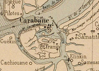
Carabane, also known as Karabane, is an island and a village located in the extreme south-west of Senegal, in the mouth of the Casamance River. This relatively recent geological formation consists of a shoal and alluvium to which soil is added by accumulation in the branches and roots of the mangrove trees which cover most of the island. Along with the rest of Ziguinchor Region, Carabane has a tropical climate, cycling between a dry season and a wet season. The island was once considered an arid location where no useful plants were likely to grow, but it now supports several types of fruit tree, the most common of which are mangos and oranges. Although the nearby Basse Casamance National Park and Kalissaye Avifaunal Reserve have been closed for years because of the Casamance Conflict, Carabane has continued to attract ornithologists interested in its wide variety of birds. Various species of fish are plentiful around the island, but there are very few mammals.

Elinkine is a town in Casamance, Senegal, located at the mouth of the Casamance River, 35 kilometres (22 mi) from Oussouye.
Cachouane is a town in Basse Casamance, southern Senegal, located in the mouth of the Casamance River, south of the island of Carabane.

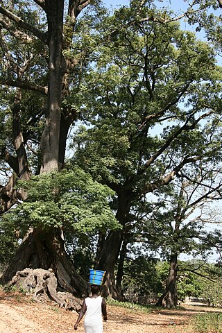
Seleki is a village in Basse Casamance in the south of Senegal. The presence of cases à impluvium, typical of Jola architecture, greatly contribute to the reputation of the village.
Emmanuel Bertrand-Bocandé (1812–1881) was an explorer, businessman, and French colonial administrator who helped spread French influence in Basse Casamance, Senegal, specifically on the island of Carabane. He left a valuable account of the French perspective on this region during colonial times.
Samatit is a village in the rural community of Mlomp, Loudia Ouoloff, Oussouye, Ziguinchor, Casamance.
Kabrousse is a village in the rural community of Diembéring, Oussouye, Ziguinchor, Casamance, Senegal. It is a coastal village located a few kilometers south of Cap Skirring. In a straight line, it is the closest place in Africa to South America. About 2 km southeast of Kabrousse is the international border with Guinea-Bissau.

Boukout is a Jola rite of passage practised in Ziguinchor, Senegal.

Baïla is a village in the rural community of Suelle, Sindian, Bignona, Ziguinchor, Casamance, Senegal.
Thionck Essyl is a small town and urban commune in Ziguinchor, Senegal, located 65 km north-west of the region capital.

Diembéring is a village in Senegal in the rural community of the same name. It is located in Cabrousse, Oussouye, Ziguinchor, Casamance, approximately 10 km north of Cap Skirring and 60 km from Ziguinchor.
Diembéring is a rural community of Senegal in Cabrousse, Oussouye, Ziguinchor, Casamance. It is situated in the west of the country along the Atlantic coast.

The Musée de la Culture Diola is a museum located in Mlomp, Casamance, Ziguinchor Region, Senegal.

Ziguinchor is the capital of the Ziguinchor Region, and the chief town of the Casamance area of Senegal, lying at the mouth of the Casamance River. It has a population of 214,874. It is the eighth largest city of Senegal, but is nearly separated from the north of the country by the nation of The Gambia.

The Villages of Senegal are the lowest level administrative division of Senegal. They are constituted "by the grouping of several families or carrés in a single agglomeration.".
