Related Research Articles

Russia, the world's largest country, comprises much of northern Eurasia, and stretches over a vast expanse of Europe and Northern Asia. Due to its size, Russia displays both monotony and diversity. As with its topography, its climates, vegetation, and soils span vast distances. From north to south the East European Plain is clad sequentially in tundra, coniferous forest (taiga), mixed and broadleaf forests, grassland (steppe), and semi-desert as the changes in vegetation reflect the changes in climate. Siberia supports a similar sequence but is predominantly taiga. The country contains forty UNESCO biosphere reserves.

Lake Baikal is a rift lake located in southern Siberia, Russia, between Irkutsk Oblast to the northwest and the Buryat Republic to the southeast.

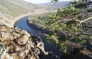
The Angara is a major river in Siberia, which traces a course through Russia's Irkutsk Oblast and Krasnoyarsk Krai. It drains out of Lake Baikal and is the headwater tributary of the Yenisey. It is 1,849 kilometres (1,149 mi) long, and has a drainage basin of 1,039,000 square kilometres (401,000 sq mi). It was formerly known as the Lower or Nizhnyaya Angara. Below its junction with the Ilim, it was formerly known as the Upper Tunguska and, with the names reversed, as the Lower Tunguska.

Irkutsk is the largest city and administrative center of Irkutsk Oblast, Russia. With a population of 617,473 as of the 2010 Census, Irkutsk is the 25th largest city in Russia by population, the 5th largest in the Siberian Federal District, and one of the largest cities in Siberia.

The Trans–Siberian Railway is a network of railways connecting Moscow with the Russian Far East. With a length of 9,289 kilometres from Moscow to Vladivostok, it is the longest railway-line in the world.

The Sayan Mountains are a mountain range in southern Siberia, Russia and northern Mongolia. In the past, it served as the border between Mongolia and Russia.

The Baikal seal, Lake Baikal seal or nerpa, is a species of earless seal endemic to Lake Baikal in Siberia, Russia. Like the Caspian seal, it is related to the Arctic ringed seal. The Baikal seal is one of the smallest true seals and the only exclusively freshwater pinniped species. A subpopulation of inland harbour seals living in the Hudson Bay region of Quebec, Canada, the Saimaa ringed seal and the Ladoga seal are found in fresh water, but these are part of species that also have marine populations.

The Selenga or Selenge is a major river in Mongolia and Buryatia, Russia. Originating from its headwater tributaries, the Ider and the Delger mörön, it flows for 992–1,024 kilometres (616–636 mi) before draining into Lake Baikal. The Selenga therefore makes up the most distant headwaters of the Yenisey-Angara river system.

Northeast Asia or Northeastern Asia is a geographical subregion of Asia; its northeastern landmass and islands are bounded by the Pacific Ocean.

The Republic of Buryatia is a federal subject of Russia, located in Siberia in Asia. Formerly part of the Siberian Federal District, it has been a part of the Russian Far East since 2018. Its capital is the city of Ulan-Ude. Its area is 351,300 square kilometers (135,600 sq mi) with a population of 972,021.

Transbaikal, Trans-Baikal, Transbaikalia, or Dauria is a mountainous region to the east of or "beyond" (trans-) Lake Baikal in Russia.

Barguzinsky Nature Reserve is the oldest of zapovedniks. It is located in Buryatia (Russia) on the west slope of the Barguzin Range, including the northeast shores of the Lake Baikal and a part of the lake itself. The name of the preserve comes from the Barguzin River. The area of the reserve is 2,482 km2 (958 sq mi). It was created in 1916 to preserve and increase the numbers of Barguzin Sable. Mountainous and taiga landscapes are also being preserved.
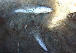
The omul, Coregonus migratorius, also known as Baikal omul, is a whitefish species of the salmon family endemic to Lake Baikal in Siberia, Russia. It is considered a delicacy and is the object of one of the largest commercial fisheries on Lake Baikal. In 2004, it was listed in Russia as an endangered species.

Severobaikalsk is a town in the Republic of Buryatia, Russia, located on the northern end of Lake Baikal at the mouth of the Tyya River, 440 kilometers (270 mi) northwest of Ulan-Ude and 490 kilometers (300 mi) northeast of Irkutsk. Population: 24,929 (2010 Census); 25,434 (2002 Census); 28,336 (1989 Census).

Lena Pillars is the name given to a natural rock formation along the banks of the Lena River in far eastern Siberia. The pillars are 150–300 metres (490–980 ft) high, and were formed in some of the Cambrian period sea-basins. The highest density of pillars is reached between the villages of Petrovskoye and Tit-Ary. The Lena Pillars Nature Park was inscribed on the World Heritage List in 2012.

Pribaikalsky National Park covers the southwest coast of Lake Baikal in southeastern Siberia. The coastal strip includes some mountain ridges to the west as well as offshore islands such as Olkhon Island to the east. It is about 50
Chikoy National Park was officially created in 2014, on the mountain-steppe border region of south-central Siberia and Mongolia. It is in the Krasnochikoysky District of the Zabaykalsky ("Trans-Baikal") administrative region of Russia. This places the park about 250 miles southeast of Lake Baikal, on the edge of the Lake Baikal ecoregion. The stated purpose for creating the park is the "preservation of unique natural complexes in the upper reaches of the river Chikoy". While tourism and sport fishing will be encouraged, hunting and roads will be prohibited.
The Trans-Baikal conifer forests ecoregion covers a 1,000 km by 1,000 km region of mountainous southern taiga stretching east and south from the shores of Lake Baikal in the Southern Siberia region of Russia, and including part of northern Mongolia. Historically, the area has been called "Dauria", or Transbaikal. It is in the Palearctic realm, and mostly in the boreal forests/taiga biome with a subarctic, humid climate. It covers 200,465 km2 (77,400 sq mi).

Baikalia is a vague geographical term referring to the region around Lake Baikal. It is less common than the concept of Transbaikalia, the area to the east of Lake Baikal. The term Baikalia is loosely defined and has no official definition.

The South Siberian Mountains are one of the largest mountain systems of the Russian Federation. The total area of the system of mountain ranges is more than 1.5 million km². The South Siberian Mountains are located in the Siberian and Far Eastern Federal Districts of Russia, as well as partly in Mongolia. The territory of the mountain system is one of the Great Russian Regions.
References
| This article about a specific sulfide mineral is a stub. You can help Wikipedia by expanding it. |