
Sabah is a state of Malaysia located on the northern portion of Borneo, in the region of East Malaysia. Sabah has land borders with the Malaysian state of Sarawak to the southwest and Indonesia's North Kalimantan province to the south. The Federal Territory of Labuan is an island just off Sabah's west coast. Sabah shares maritime borders with Vietnam to the west and the Philippines to the north and east. Kota Kinabalu is the region capital city, the economic centre of the region, and the seat of the Sabah region government. Other major towns in Sabah include Sandakan and Tawau. The 2020 census recorded a population of 3,418,785 in the state. It has an equatorial climate with tropical rainforests, abundant with animal and plant species. The state has long mountain ranges on the west side which forms part of the Crocker Range National Park. Kinabatangan River, the second longest river in Malaysia runs through Sabah. The highest point of Sabah, Mount Kinabalu is also the highest point of Malaysia.

East Malaysia, or the Borneo States, also known as Malaysian Borneo, is the part of Malaysia on and near the island of Borneo, the world's third-largest island. East Malaysia comprises the states of Sabah, Sarawak, and the Federal Territory of Labuan. The small independent nation of Brunei lies sandwiched between Sabah and Sarawak. To the south and southeast is the Indonesian portion of Borneo, Kalimantan. East Malaysia lies to the east of Peninsular Malaysia, the part of the country on the Malay Peninsula. The two are separated by the South China Sea.
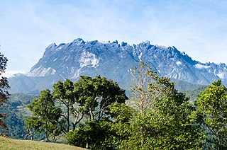
Mount Kinabalu is the highest mountain in Borneo and Malaysia. With an elevation of 13,435 feet (4,095 m), it is third-highest peak of an island on Earth, and 20th most prominent mountain in the world by topographic prominence. The mountain is located in Ranau district, West Coast Division of Sabah, Malaysia. It is protected as Kinabalu Park, a World Heritage Site.

Kota Kinabalu, colloquially referred to as KK, is the state capital of Sabah, Malaysia. It is also the capital of the Kota Kinabalu District as well as the West Coast Division of Sabah. The city is located on the northwest coast of Borneo facing the South China Sea. The Tunku Abdul Rahman National Park lies to its west and Mount Kinabalu, which gave the city its name, is located to its east. Kota Kinabalu has a population of 452,058 according to the 2010 census; when the adjacent Penampang and Putatan districts are included, the metro area has a combined population of 628,725. The 2020 Census revealed an increase in the municipal population to 500,421, while the wider area including Penampang and Putatan Districts had a population of 731,406.

Kudat is the capital of the Kudat District in the Kudat Division of Sabah, Malaysia. Its population was estimated to be around 29,025 in 2010. It is located on the Kudat Peninsula, about 190 kilometres (120 mi) north of Kota Kinabalu, the state capital, and is near the northernmost point of Borneo. It is the largest town in the heartland of the Rungus people which is a sub-ethnic group of the majority Kadazan-Dusun race and is therefore a major centre of Rungus culture. It is also notable for being one of the first parts of Sabah to be settled by Chinese Malaysians, particularly from the Hakka dialect group. It is the Northernmost Malaysian city.
Kinabalu Park, established as one of the first national parks of Malaysia in 1964, is Malaysia's first World Heritage Site designated by UNESCO in December 2000 for its "outstanding universal values" and the role as one of the most important biological sites in the world with more than 4,500 species of flora and fauna, including 326 bird and around 100 mammal species, and over 110 land snail species.

The Ranau District is an administrative district in the Malaysian state of Sabah, part of the West Coast Division which includes the districts of Kota Belud, Kota Kinabalu, Papar, Penampang, Putatan, Ranau and Tuaran. The capital of the district is in Ranau Town. The landlocked district bordering the Sandakan Division to the east until it meets the Interior Division border. Ranau sits 108 km (67 mi) east of Kota Kinabalu and 227 km (141 mi) west of Sandakan. As of the 2010 Census, the population of the district was 94,092, an almost entirely Dusun ethnic community.

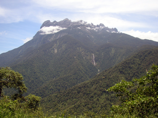
Mount Tambuyukon or Tamboyukon is a mountain located at the West Coast Division of Sabah, Malaysia. It is considered the third-highest mountain in the country with height at 2,579 metres (8,461 ft), lying north of the highest Mount Kinabalu.

Nepenthes villosa, or the villose pitcher-plant, is a tropical pitcher plant endemic to Mount Kinabalu and neighbouring Mount Tambuyukon in northeastern Borneo. It grows at higher elevations than any other Bornean Nepenthes species, occurring at elevations of over 3,200 m (10,500 ft). Nepenthes villosa is characterised by its highly developed and intricate peristome, which distinguishes it from the closely related N. edwardsiana and N. macrophylla.
Nepenthes burbidgeae, also known as the painted pitcher plant or Burbidge's Pitcher-Plant, is a tropical pitcher plant with a patchy distribution around Mount Kinabalu and neighbouring Mount Tambuyukon in Sabah, Borneo.
Datin Anthea Phillipps B.Sc. is a British botanist based in Sabah, Malaysia, specialising in pitcher plants and rhododendrons.

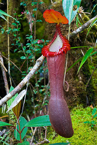
Nepenthes × kinabaluensis, or the Kinabalu pitcher-plant, is the natural hybrid between N. rajah and N. villosa. It was first collected near Kambarangoh on Mount Kinabalu, Borneo by Lilian Gibbs in 1910 and later mentioned by John Muirhead Macfarlane as "Nepenthes sp." in 1914. Although Macfarlane did not formally name the plant, he noted that "[a]ll available morphological details suggest that this is a hybrid between N. villosa and N. rajah". It was finally described in 1976 by Shigeo Kurata as N. × kinabaluensis. The name was first published in Nepenthes of Mount Kinabalu, but was a nomen nudum at the time as it lacked an adequate description and information on the type specimen. The name was subsequently published validly by Kurata in 1984.
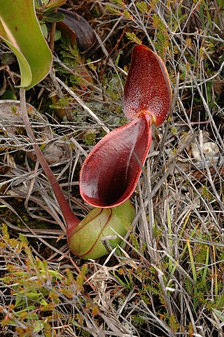
Nepenthes lowii, or Low's pitcher-plant, is a tropical pitcher plant endemic to Borneo. It is named after Hugh Low, who discovered it on Mount Kinabalu. This species is perhaps the most unusual in the genus, being characterised by its strongly constricted upper pitchers, which bear a greatly reduced peristome and a reflexed lid with numerous bristles on its lower surface.
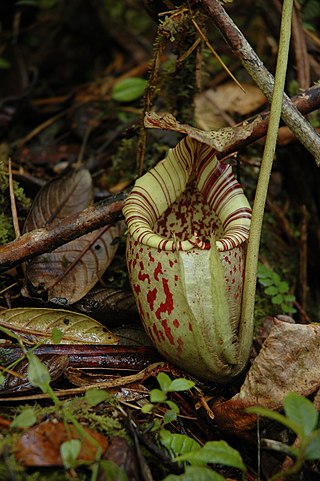
Nepenthes edwardsiana, or the splendid pitcher-plant, is a carnivorous tropical pitcher plant endemic to Mount Kinabalu and neighbouring Mount Tambuyukon in Sabah, Malaysian Borneo. It is considered one of the most spectacular of all Nepenthes, producing some of the largest pitchers and the most highly developed peristome ribs of any species in the genus.

Nepenthes fusca, or the dusky pitcher-plant, is a tropical pitcher plant endemic to Borneo. It is found throughout a wide altitudinal range and is almost always epiphytic in nature, primarily growing in mossy forest.
Nepenthes macrovulgaris, or the serpentine pitcher-plant, is a tropical pitcher plant endemic to Borneo. It is a lowland plant that typically grows at altitudes ranging from 300 to 1200 m in sub-montane forest clearings and mossy forest. Its range is restricted to ultramafic habitats, including Mount Kinabalu, Mount Tambuyukon, the Danum Valley, the Tawai Range, the Meliau Range and Mount Silam, all in Sabah, Malaysian Borneo. Pitchers grow to around 25 cm high and range in colour from green to brown, with the speckled form being the most common.

Mesilau, named after Mesilau River, is an area situated at approximately 2,000 m (6,562 ft) above sea level on the East Ridge of Mount Kinabalu in Kinabalu National Park, Sabah, Malaysian Borneo. It is the site of the Mesilau Nature Resort, which is owned and operated by Sutera Sanctuary Lodges.
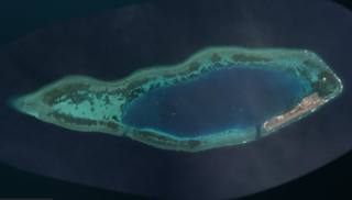
Swallow Reef, also known as Malay: Pulau Layang-Layang; Vietnamese: Đá Hoa Lau; Mandarin Chinese: 燕子島; pinyin: Yànzi Dǎo; Celerio Reef, is an oceanic atoll of the Spratly Islands administered by Malaysia, which is situated approximately 300 kilometres (190 mi) northwest of Kota Kinabalu, Sabah. The atoll is about 7 km long and 2 km wide with a central lagoon. The part of the atoll above sea level is a reef on the south-east rim which had an original land area of approximately 6.2 hectares, but with reclaimed land now covers 35 hectares, measuring over 1.5 kilometres (0.93 mi) long and 200 m (656 ft) wide.

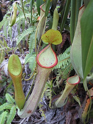
Nepenthes of Mount Kinabalu is a monograph by Shigeo Kurata on the tropical pitcher plants of Mount Kinabalu and the surrounding area of Kinabalu National Park in Sabah, Borneo. It was published in 1976 by Sabah National Parks Trustees as the second booklet of the Sabah National Parks series. The monograph is Kurata's most important work on Nepenthes and significantly contributed to popular interest in these plants. It is noted for its high quality colour photographs of plants in habitat. In the book's preface, Kurata writes:
While Nepenthes were often enumerated as an important component of the flora of this mountain, a book on this genus—relating exclusively to Kinabalu had never been published to this date. With such a situation and the interest shown by visitors to the Kinabalu National Park in the genus, Mr. D.V. Jenkins, Assistant Director, Sabah National Parks was prompted to publish a guide book on the species found within the park and I was delighted to be asked to write the text.
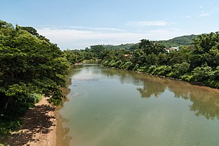
The Tuaran River is a river in West Coast Division, northwestern Sabah of Malaysia. It has a total length of 80 km (50 mi) from its headwaters in the mountains of northwest Sabah to its outlet at the South China Sea, northwest of Tuaran town.