
A funicular is one of the modes of transportation which uses a cable traction for movement on steep inclined slopes.

An aerial tramway, sky tram,cable car, ropeway or aerial tram is a type of aerial lift which uses one or two stationary ropes for support while a third moving rope provides propulsion. With this form of lift, the grip of an aerial tramway cabin is fixed onto the propulsion rope and cannot be decoupled from it during operations.

The Seilbahn Zugspitze is an aerial tramway running from the Eibsee Lake to the top of Zugspitze. It currently holds the world record for the longest freespan in a cable car at 3,213 metres (10,541 ft). Construction of the system began in 2015 and it opened on 22 December 2017.
The Gant-Hohtälli Aerial Tramway is a large-cab cable car near Zermatt, Switzerland. It is 2707 metres long and spans an elevation of some 1057 metres. This cable car is notable in that it runs over the tallest aerial lift pylon in Switzerland, with a height of 94 metres.

The Glacial Aerial Tramway Kaprun III is the third section of the aerial tramway on the Kitzsteinhorn mountain at Kaprun, Austria. It was placed in service on 26 November 1966. It is currently branded Gipfelbahn.

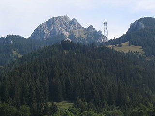
The Tegelberg Cable Car, on the Tegelberg mountain near Schwangau in southern Bavaria. The cable car is 2,146.18 metres long, climbs a height of 892.5 metres, has a carrying cable of 48 mm in diameter and a hauling cable of 26 mm in diameter. It has two cabins each capable of transporting up to 44 persons. They are driven by a 2,540 KW engine. The cableway has a 38 metre high support pillar, made of reinforced concrete.
The Wendelstein Cable Car (Wendelstein-Seilbahn) is a 2,953-metre (9,688-foot) long cable car running from Bayrischzell Osterhofen to Mount Wendelstein. It has a maximum speed of 10 m/s (32.8 ft/s) and its travel time is 6.5 minutes. The cabins each take up to 50 passengers, and the cable car system has a transport capacity of 450 people per hour. The cable car climbs an altitude difference of 932 metres.
The Nebelhorn Cable Car in Oberstdorf, Germany is a cable car on the Nebelhorn mountain that was constructed in 3 sections. It was first built between 1928 and 1930 and rebuilt in 1977 and 1991. The first section of the Nebelhorn cable car, renewed in 1977, has a length of 2,202.68 metres, a carrying cable of 55 mm and a hauling cable of 21 mm in diameter. It climbs a total height of 452 metres.

The Predigtstuhl Cable Car has been in operation since 1928 and is the oldest, still running, original large-cabin cable car in the world. Since 2006, the ropeway has been placed under the protection of monuments. And in 2013 the "Predigstuhlbahn" as well as the hotel and mountain's top restaurant got a new ownership, "Marga und Josef Posch", which belongs to the German businessman group Max Eicher.

The Herzogstand Cable Car was built in 1994 as replacement for a 4,500-foot (1,400 m) chair lift through the Bavarian alps. Its two cabins carry passengers from Lake Walchensee to the Fahrenberg mountain on the upper slopes of the Herzogstand mountain. The cableway uses a 43 mm (1.7 in) carrying cable and a 21 mm (0.83 in) hauling cable. The cable car is driven by a 185 kilowatt engine. The cable way has two supports, which are 28 metres (92 ft) and 24 metres (79 ft) high. The journey time each way is four minutes and the cars reach a top speed of 8 metres per second (18 mph).

Cermis is a mountain of the Lagorai group in eastern Trentino, Italy in the comune of Cavalese.

The Chiemgau Alps are a mountain range in the Northern Limestone Alps and therefore belong to the Eastern Alps. Their major part is situated in Bavaria, Germany and only a small section crosses the Austrian border into the states of Salzburg and Tirol. They reach their highest elevation (1961 m) in the Sonntagshorn, a peak straddling the German-Austrian border.

The Zugspitzebahn was the first wire ropeway to open the summit of the Zugspitze, Germany's highest mountain on the border of Austria. Designed and built by Adolf Bleichert & Co. of Leipzig, Germany, the system was a record-holder for highest altitude. Opening in 1926, the Zugspitzebahn connected the Austrian town of Ehrwald with the top station at 2,950 metres above sea level next to the summit of Zugspitze.

The Adliswil-Felsenegg cable car is a cable car in the canton of Zürich in Switzerland. The lower station is located in Adliswil in the Sihl Valley, whilst the upper station is located on the Felsenegg hill on the Albis ridge near the Felsenegg-Girstel TV-tower. The upper station at Felsenegg forms one end of a panoramic walk to the Uetliberg mountain, whilst the lower station is some 400 metres (1,300 ft) from Adliswil railway station.

The Kitzbüheler Horn is one of the most important mountains in the Kitzbühel Alps in Tyrol, Austria, whose eastern flank lies near the smart ski resort of Kitzbühel. With a height of 1,996 m (AA) it only just misses being a 'two-thousander'.
Ćuška or Qyshk is a village near Peć, in western Kosovo. It is predominantly inhabited by Muslim ethnic Albanians.

The Augustusburg Cable Railway is a funicular railway in Saxony, Germany. It connects the station of Erdmannsdorf-Augustusburg, in the village of Erdmannsdorf and on the Annaberg-Buchholz–Flöha railway, with the town of Augustusburg on the hill above.

The Wendelstein Rack Railway, sometimes just referred to as the Wendelstein Railway, is an electrically-driven metre gauge rack railway that runs up the Wendelstein in the Upper Bavarian Limestone Alps. Together with the Wendelstein Cable Car (Wendelstein-Seilbahn) it is operated by the Wendelsteinbahn GmbH. The mountain railway climbs through a total height of 1,217.27 metres. The Wendelstein Railway is one of only four working rack railways in Germany, the others being the Bavarian Zugspitze Railway, the Drachenfels Railway and the Stuttgart Rack Railway.

The Zugspitze Glacier Cable Car is a 1,000 metre long cable car on the Zugspitze, Germany's highest mountain. It was opened in 1992 and links the plateau of the Zugspitzplatt directly with the summit, 360 metres higher. Since the mountain station of the Bavarian Zugspitze Railway was moved from the Schneefernerhaus to the Platt, the Schneefernerhaus and the old cableways, which ran down into the valley from the Platt and up to the summit (Gipfelseilbahn), have lost their importance.

The Fellhorn Lift is a two-section gondola lift in the German Alps that runs from Birgsautal in Oberstdorf to the peak of the Fellhorn – 1,967 metres above sea level (NN).


