Related Research Articles

Mount Kailash is a mountain in Ngari Prefecture, Tibet Autonomous Region of China. It lies in the Kailash Range of the Transhimalaya, in the western part of the Tibetan Plateau. The peak of Mount Kailash is located at an elevation of 6,638 m (21,778 ft), near the western trijunction between China, India and Nepal.

Lake Manasarovar, also called Mapam Yumtso locally, is a high altitude freshwater lake near Mount Kailash in Burang County, Ngari Prefecture, Tibet Autonomous Region, China. It is located at an elevation of 4,600 m (15,100 ft), near the western trijunction between China, India and Nepal. It overflows into the adjacent salt-water lake of Rakshastal via the Ganga Chhu. The sources of four rivers: Indus, Sutlej, Brahmaputra, and Karnali lie in the vicinity of the region.

Nathu La(Tibetan: རྣ་ཐོས་ལ་, Wylie: Rna thos la, THL: Na tö la, Sikkimese: རྣ་ཐོས་ལ་) is a mountain pass in the Dongkya Range of the Himalayas between China's Yadong County in Tibet, and the Indian states of Sikkim. But minor touch of Bengal in South Asia. The pass, at 4,310 m (14,140 ft), connects the towns of Kalimpong and Gangtok to the villages and towns of the lower Chumbi Valley.
The Border Roads Organisation (BRO) is a statutory body under the ownership of the Ministry of Defence of the Government of India. BRO develops and maintains road networks in India's border areas and friendly neighboring countries. This includes infrastructure operations in 19 states and three union territories and neighboring countries such as Afghanistan, Bhutan, Myanmar, Tajikistan and Sri Lanka. By 2022, BRO had constructed over 55,000 kilometres (34,000 mi) of roads, over 450 permanent bridges with a total length of over 44,000 metres (27 mi) length and 19 airfields in strategic locations. BRO is also tasked with maintaining this infrastructure including operations such as snow clearance.

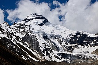
Om Parvat is a mountain located in Pithoragarh district, Uttarakhand, India. Om Parvat's peak elevation is 5,590 m (18,340 ft) above sea level.

Dharchula is a town in Pithoragarh district in the northern state of Uttarakhand, India, situated at an elevation of 940 m above sea level, surrounded by peaks from all sides and Kali river cutting through the middle, dividing the area into two towns on either banks of the river - one in India and the other in Nepal. River Kali originates from Kala Pani at Lipulekh Pass and forms the border between India and Nepal. People of the two towns have similar traditions, culture, and lifestyle, and can move across the border without a passport or visa. The area has a mixture of Kumaouni and Rung language, traditions and culture. Dharchula lies about 92 km (57 mi) north of Pithoragarh - the district town, along the route of the Kailash-Mansarovar pilgrimage tour. It lies on the Pithoragagh-Lipulekh Pass Highway (PLPH).
Kuti Valley is a Himalayan valley, an area administered by India and also claimed by Nepal, is situated in the Pithoragarh district of Uttrakhand state of India. It is the last valley before the border with Tibet. It runs along the Limpiyadhura Pass & Adi Kailash in northwest to Gunji in southeast axis, formed by the river Kuti Yankti, which is one of the headwaters of the Kali River. It is reached by the Pithoragagh-Lipulekh Pass Highway (PLPH).
The Lipulekh Pass is a Himalayan pass on the border between Uttarakhand, India and the Tibet region of China, near their trijunction with Nepal. Nepal has had ongoing claims to the southern side of the pass, called Kalapani territory, which has been under Indian administration since around 1960, but this issue is often downplayed by the Indian government. The pass is near the trading town of Taklakot (Purang) in Tibet and has been used since ancient times by traders, mendicants and pilgrims transiting between India and Tibet. It is also used by pilgrims to Kailas and Manasarovar.
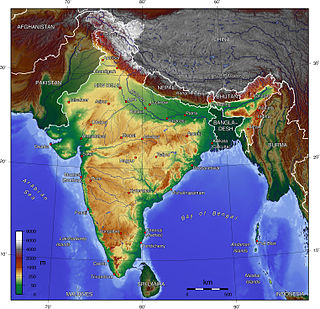
The Indian Himalayan Region is the section of the Himalayas within the Republic of India, spanning thirteen Indian states and union territories, namely Ladakh, Jammu and Kashmir, Himachal Pradesh, Uttarakhand, Sikkim, West Bengal, Manipur, Meghalaya, Mizoram, Nagaland, Tripura, Assam, and Arunachal Pradesh. The region is responsible for providing water to a large part of the Indian subcontinent and contains various flora and fauna.
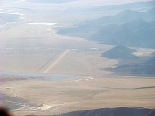
Fukche Advanced Landing Ground is an airfield in the Demchok sector of the union territory of Ladakh, India. It was built shortly before the 1962 Sino-Indian War and was revived in 2008. It is located adjacent to Koyul, 34 km northwest of Demchok.
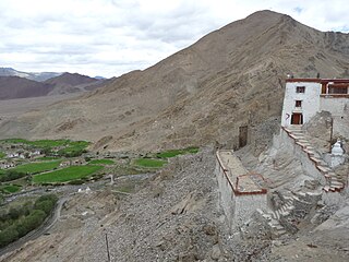
Nyoma is a principal village of southern Ladakh in India, the headquarters of an eponymous subdivision, tehsil, community development block and Indian Air Force Base in the Leh district. It is located on the bank of the Indus river after its 90-degree bend near Dungti east of Nyoma and before the valley narrows to a gorge near Mahe northwest of Nyoma. The Nyoma tehsil and subdivision cover all of southern Ladakh, including the Rupshu plains south of Nyoma, the Indus valley of Skakjung north of Nyoma, and the Hanle valley. Nyoma gompa, a Buddhist monastery, is located on the hill slope north of the village.
The Kalapani territory is an area under Indian administration as part of Pithoragarh district in the Kumaon Division of the Uttarakhand state, but it is also claimed by Nepal since 1997. According to Nepal's claim, it lies in Darchula district, Sudurpashchim Province. The territory represents part of the basin of the Kalapani river, one of the headwaters of the Kali River in the Himalayas at an altitude of 3600–5200 meters. The valley of Kalapani, with the Lipulekh Pass at the top, forms the Indian route to Kailash–Manasarovar, an ancient pilgrimage site. It is also the traditional trading route to Tibet for the Bhotiyas of Kumaon and the Tinkar valley of Nepal.
Gunji is a small village in Uttarakhand, India. It is near the borders of Tibet and Nepal and the confluence of the Kuthi Yankti and Kalapani River, at the east end of the Kuthi Valley. The village is on the traditional Indian/Nepalese route to Kailas–Manasarovar.
Adi Kailash, also known as Shiva Kailash, Chota Kailash, Baba Kailash or Jonglingkong Peak, is a mountain located in the Himalayan mountain range in the Pithoragarh district of Uttarakhand, India. It is the second most important peak among the group of five separate peaks in Himalayas in separate locations collectively known as the Panch Kailash or "Five Kailashas", others being Mount Kailash in the first place, Shikhar Kailash in the third, Kinnaur Kailash in the fourth and Manimahesh Kailash in the fifth place in terms of importance. Gauri Kund and Parvati Tal glacial lakes are at the base of the Adi Parvat.

Char Dham National Highway, is an under construction two-lane 889 km long National Highway with a minimum width of 10 metres in the Indian state of Uttarakhand under Char Dham Pariyojana. The under construction highway will complement the under-construction Char Dham Railway by connecting the four holy places in Uttarakhand states namely Badrinath, Kedarnath, Gangotri and Yamunotri. The project includes 889 km national highways which will connect the whole of Uttarakhand state. It will connect Delhi–Dehradun Expressway on its southern end to India-China Border Roads on its northern ends.

Pallavi Fauzdar is an Indian woman best known for her high altitude motorcycle riding and her social work. Her exploits have been recognised by a number of firsts in the Limca Book of Records.

Border Personnel Meeting points are locations along the disputed Sino-Indian territories on Line of Actual Control (LAC) where the armies of both countries hold ceremonial and practical meetings to resolve border issues and improve relations. While border meetings have been held since the 1990s, the first formal Border Personnel Meeting point was established in 2013. There are five meeting points: two in the Indian Union Territory of Ladakh, one in Sikkim, and two in Arunachal Pradesh in India's Central and Eastern sectors.
India–China Border Roads is a Government of India project for developing infrastructure along the Sino-Indian border by constructing strategic roads, including bridges and tunnels. The ICBR project is largely in response to Chinese infrastructure development along the borderlands with India. Several entities are responsible for constructing ICBR, including Border Roads Organisation (BRO) which handles the bulk of the ICBR road construction work, National Highways Authority of India (NHAI), National Highways and Infrastructure Development Corporation Limited (NHIDCL), Ministry of Development of North Eastern Region (MoDNER), Central Public Works Department (CPWD), public works departments of respective states and others. At least 67 per cent of the road network assigned to BRO falls under ICBR.
The National Highways & Infrastructure Development Corporation Limited (NHIDCL) is a fully owned company of the Government of India, set up in 2014 and is responsible for management of a network of over 10,000 km of National Highways out of 1,15,000 km in India. It is a nodal agency of the Ministry of Road Transport and Highways (MoRTH).
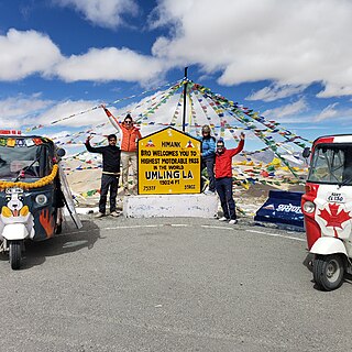
Umling La or Umlung La is the highest paved road and mountain pass in the world, located in Ladakh, India, on the ridgeline between Koyul Lungpa and the Indus River near Demchok. At an elevation of 19,024 feet (5,799 m), it forms the source for the Umlung stream that drains into the Indus and a tributary of the Kiungdul river that drains into Koyul Lungpa.
References
- 1 2 3 4 5 6 7 "Jharkhand woman creates history as 1st biker to scale Lipulekh Pass". India Today. 2024-11-02. Retrieved 2024-12-01.
- 1 2 3 4 Roy, Dyuti (2022-01-24). "Kanchan Ugursandi: Woman motorcyclist from Jharkhand hits road with a cause". The New Indian Express. Retrieved 2024-12-01.
- ↑ PTI (2021-07-08). "Kanchan Ugursandi finishes world's first solo motorcycle expedition covering 18 passes of Himalayas". The New Indian Express. Retrieved 2024-12-01.
- ↑ "Indian Army's BRO sets Guinness World Record for world's highest motorable road". Hindustan Times Auto News. 21 November 2021. Archived from the original on 21 November 2021. Retrieved 7 December 2024.
- ↑ "Kanchan Ugursandi finishes world's 1st solo motorcycle expedition covering 18 Himalayan passes". The Tribune. Retrieved 2024-12-01.