The arrondissement of Lodève is an arrondissement of France. It is part of the Hérault département. Its INSEE code is 342 and its capital city is Lodève. Since the January 2017 reorganization of the arrondissements of Hérault, it has 122 communes.

Bagré is a department or commune of Boulgou Province in eastern Burkina Faso. Its capital lies at the town of Bagré. According to the 2006 census, actualized for the municipal élections of 2013, the department has a total population of 29,164.

Bané is a department or commune of Boulgou Province in eastern Burkina Faso. Its capital lies at the town of Bané. According to the 1996 census the department has a total population of 22,923.
Bissiga is a department or commune of Boulgou Province in eastern Burkina Faso. Its capital lies at the town of Bissiga. According to the 1996 census the department has a total population of 19,264.
Bittou is a department or commune of Boulgou Province in eastern Burkina Faso. Its capital lies at the town of Bittou. According to the 1996 census the department has a total population of 34,496.
Garango is a department or commune of Boulgou Province in eastern Burkina Faso. Its capital lies at the town of Garango. According to the 1996 census the department has a total population of 67,737.
Komtoèga is a department or commune of Boulgou Province in eastern Burkina Faso. Its capital lies at the town of Komtoèga. According to the 1996 census the department has a total population of 18,917.
Zoaga is a department or commune of Boulgou Province in eastern Burkina Faso. Its capital lies at the town of Zoaga. According to the 1996 census the department has a total population of 11,295.
Zonsé is a department or commune of Boulgou Province in eastern Burkina Faso. Its capital lies at the town of Zonsé. According to the 1996 census the department has a total population of 19,916.

Mangodara is a department or commune of Comoé Province in southern Burkina Faso. Its capital lies at the town of Mangodara. According to the 1996 census the department has a total population of 44,444.
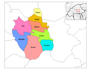
Kogho is a department or commune of Ganzourgou Province in central-eastern Burkina Faso. Its capital lies at the town of Kogho. According to the 1996 census the department has a total population of 15,524.
Méguet is a department or commune of Ganzourgou Province in central-eastern Burkina Faso. Its capital lies at the town of Méguet. According to the 1996 census the department has a total population of 34,668.
Mogtédo is a department or commune of Ganzourgou Province in central-eastern Burkina Faso. Its capital lies at the town of Mogtédo. According to the 2006 general population census, actualized in 2012 for the municipal elections, the department has a total population of 44,668.
Zam is a department or commune of Ganzourgou Province in central-eastern Burkina Faso. Its capital lies at the town of Zam. According to the 1996 census the department has a total population of 39,259.
Zorgho is a department or commune of Ganzourgou Province in central-eastern Burkina Faso. Its capital lies at the town of Zorgho. According to the 1996 census the department has a total population of 49,648.
Zoungou is a department or commune of Ganzourgou Province in central-eastern Burkina Faso. Its capital lies at the town of Zoungou. According to the 1996 census the department has a total population of 29,753.

Kombori is a department or commune of Kossi Province in western Burkina Faso. Its capital lies at the town of Kombori. According to the 1996 census the department has a total population of 9,610.

Gounghin is a department of Kouritenga Province in eastern Burkina Faso. Its capital lies at the town of Gounghin. According to the 2006 census the department has a total population of 35,257.
Salogo is a department or commune of Ganzourgou Province in central-eastern Burkina Faso. Its capital lies at the town of Salogo. According to the 2006 census, the department has a total population of 21,405.


