Related Research Articles
Frobisher Bay is an inlet of the Davis Strait in the Qikiqtaaluk Region of Nunavut, Canada. It is located in the southeastern corner of Baffin Island. Its length is about 230 km (140 mi) and its width varies from about 40 km (25 mi) at its outlet into the Labrador Sea to roughly 20 km (12 mi) towards its inner end.
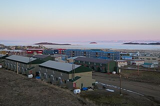
Rankin Inlet is an Inuit hamlet on Kudlulik Peninsula in Nunavut, Canada. It is the largest hamlet and second-largest settlement in Nunavut, after the territorial capital, Iqaluit. On the northwestern Hudson Bay, between Chesterfield Inlet and Arviat, it is the regional centre for the Kivalliq Region.

The Qikiqtaaluk Region, Qikiqtani Region or Baffin Region is the easternmost administrative region of Nunavut, Canada. Qikiqtaaluk is the traditional Inuktitut name for Baffin Island. Although the Qikiqtaaluk Region is the most commonly used name in official contexts, several notable public organizations, including Statistics Canada prefer the older term Baffin Region.

King William Island is an island in the Kitikmeot Region of Nunavut, which is part of the Arctic Archipelago. In area it is between 12,516 km2 (4,832 sq mi) and 13,111 km2 (5,062 sq mi) making it the 61st-largest island in the world and Canada's 15th-largest island. Its population, as of the 2016 census, was 1,279, all of whom live in the island's only community, Gjoa Haven.

The umiak, umialak, umiaq, umiac, oomiac, oomiak, ongiuk, or anyak is a type of open skin boat, used by both Yupik and Inuit, and was originally found in all coastal areas from Siberia to Greenland. First arising in Thule times, it has traditionally been used in summer to move people and possessions to seasonal hunting grounds and for hunting whales and walrus. Although the umiak was usually propelled by oars (women) or paddles (men), sails—sometimes made from seal intestines—were also used, and in the 20th century, outboard motors. Because the umiak has no keel, the sails cannot be used for tacking.

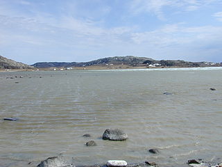
Ulukhaktok is a small hamlet on the west coast of Victoria Island, in the Inuvik Region of the Northwest Territories, Canada.
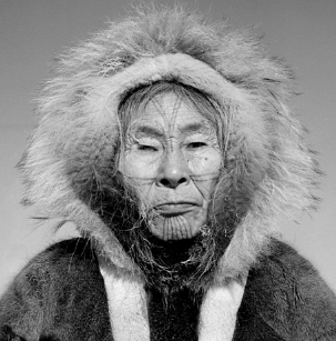
Helen Kalvak, (Kalvakadlak) was a Copper Inuit graphic artist from Ulukhaktok, Northwest Territories, Canada.

Bathurst Inlet,, is a small Inuit community located in Bathurst Inlet in the Kitikmeot Region of Nunavut, Canada. As of the 2016 census the population remained at zero.
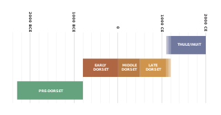
The history of Nunavut covers the period from the arrival of the Paleo-Eskimo thousands of years ago to present day. Prior to the colonization of the continent by Europeans, the lands encompassing present-day Nunavut were inhabited by several historical cultural groups, including the Pre-Dorset, the Dorsets, the Thue and their descendants, the Inuit.

Nunavut is the newest, largest, and most northerly territory of Canada. It was separated officially from the Northwest Territories on April 1, 1999, via the Nunavut Act and the Nunavut Land Claims Agreement Act, though the boundaries had been drawn in 1993. The creation of Nunavut resulted in the first major change to Canada's political map since incorporating the province of Newfoundland in 1949.

Caribou Inuit, barren-ground caribou hunters, are bands of inland Inuit who lived west of Hudson Bay in Keewatin Region, Northwest Territories, now the Kivalliq Region of present-day Nunavut between 61° and 65° N and 90° and 102° W in Northern Canada. They were originally named "Caribou Eskimo" by the Danish Fifth Thule Expedition of 1921-4 led by Knud Rasmussen. Caribou Inuit are the southernmost subgroup of the Central Inuit.
Copper Inuit are a Canadian Inuit group who live north of the tree line, in what is now Nunavut's Kitikmeot Region and the Northwest Territories's Inuvik Region. Most historically lived in the area around Coronation Gulf, on Victoria Island, and southern Banks Island.

Minto Inlet is located east of Amundsen Gulf in western Victoria Island, at the southern end of Prince of Wales Strait in the Northwest Territories. It is 75 mi (121 km) long and between 8–25 mi (13–40 km) wide.
Walker Bay is a Canadian Arctic waterway in the Northwest Territories. It is an eastern arm of Amundsen Gulf. The bay is located on western Victoria Island, between Jago Bay, in the north, and Minto Inlet, in the south. It is at the south entrance of Prince of Wales Strait. Fort Collinson is on the bay's northern shore.
Cape Baring is a Canadian Arctic headland in the Northwest Territories. The most westerly point of the Wollaston Peninsula, it is located on Victoria Island, protruding into the Amundsen Gulf.
The Kangiryuarmiut were a Copper Inuit subgroup. They were located on Victoria Island in the areas of Prince Albert Sound, Cape Baring, and central Victoria island. They were also found around Nelson Head on Banks Island. Kangiryuarmiut subsisted on bear. They were the only Copper Inuit who built iglooit on land. The Kangiryuarmiut speak the Kangiryuarmiutun subdialect of Inuinnaqtun dialect of Inuvialuktun language.
The Umingmuktogmiut are a geographically defined Copper Inuit band in the northern Canadian territory of Nunavut, Kitikmeot Region. They were located on the western coast of Kiillinnguyaq, and also further south in eastern Bathurst Inlet around Everitt Point by the Barry Islands. Umingmuktogmiut were notable amongst other Copper Inuit as they had a permanent community, Umingmuktog. They could hunt and fish for Arctic char, Arctic fox, barren-ground caribou, fur seals, and muskox prevalent in the area.
The Ugyuligmiut were a geographically defined Copper Inuit band in the Canadian Arctic's Northwest Territories. They were located on Victoria Island north of Minto Inlet, and on Banks Island in the Aulavik National Park region.
Tahiryuaq, formerly Tahiryuak Lake, is a lake located in the Canadian Arctic's Northwest Territories. It is situated in northcentral Victoria Island, north of Prince Albert Sound, southeast of Minto Inlet.
Fort Collinson was a trading post operated by the Hudson's Bay Company located on Victoria Island in the Northwest Territories, Canada. It is situated on the Prince Albert Peninsula on the north side of Walker Bay, just north of Minto Inlet.
References
- ↑ Stefansson, V. (1914-12-30). "Prehistoric and Present Commerce among the Arctic Coast Eskimo". Geological Survey Museum Bulletin. 6: 14. ISBN 0-665-82395-9.
- ↑ Condon, R.G. (1987). Inuit youth : growth and change in the Canadian Arctic . New Brunswick, NJ: Rutgers University Press. pp. 25–38. ISBN 0-8135-1212-3.
Copper Inuit.
- ↑ "Migrations Abstracts". canadian-studies.info. Archived from the original on 2010-10-01. Retrieved 2008-11-04.
| This article relating to the Indigenous peoples of North America is a stub. You can help Wikipedia by expanding it. |
| This Northwest Territories-related article is a stub. You can help Wikipedia by expanding it. |
| This Nunavut-related article is a stub. You can help Wikipedia by expanding it. |