Kani, Ivory Coast

Last updated
Kani
Cote d'Ivoire adm location map.svg
Red pog.svg
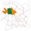
Kani
Location in Ivory Coast
Coordinates: 8°29′N6°36′W / 8.483°N 6.600°W / 8.483; -6.600
CountryFlag of Cote d'Ivoire.svg  Ivory Coast
District Woroba
Region Worodougou
Department Kani
Population
 (2014) [1]
  Total
31,211
Time zone UTC+0 (GMT)

Kani is a town in north-western Ivory Coast. It is a sub-prefecture of and the seat of Kani Department in Worodougou Region, Woroba District. Kani is also a commune. In 2014, the population of the sub-prefecture of Kani was 31,211. [2]

Villages

The fifteen villages of the sub-prefecture of Kani and their population in 2014 are: [2]

  1. Banagoro (300)
  2. Gbédéguéla (1 523)
  3. Kani (8 908)
  4. Katogbo (912)
  5. Komatou (883)
  6. Tabakoroni (532)
  7. Tiesso (453)
  8. Babasso (1 782)
  9. Frototou (1 677)
  10. Kabélékoro (275)
  11. Manabri (2 611)
  12. Massasso-Bas-Yani (2 326)
  13. Silakoro (1 708)
  14. Soba (2 419)
  15. Wongué (4 902)

Notes

  1. "Côte d'Ivoire". geohive.com. Retrieved 14 December 2015.
  2. 1 2 "RGPH 2014, Répertoire des localités, Région Worodougou" (PDF). ins.ci. Retrieved 5 August 2019.