Related Research Articles

Kansas City is the third-most populous city in the U.S. state of Kansas, and the county seat of Wyandotte County. It is an inner suburb of the older and more populous Kansas City, Missouri, after which it is named. As of the 2020 census, the population of the city was 156,607, making it one of four principal cities in the Kansas City metropolitan area. It is situated at Kaw Point, the junction of the Missouri and Kansas rivers. It is part of a consolidated city-county government known as the "Unified Government". It is the location of the University of Kansas Medical Center and Kansas City Kansas Community College.

Blue Springs is a city located in the U.S. state of Missouri within Jackson County. Blue Springs is located 19 miles (31 km) east of downtown Kansas City. Blue Springs is the 9th largest city in the Kansas City Metropolitan Area and 10th largest city in the state of Missouri. As of the 2020 census, the population was 58,604.
The Kansas City metropolitan area is a bi-state metropolitan area anchored by Kansas City, Missouri. Its 14 counties straddle the border between the U.S. states of Missouri and Kansas. With 8,472 square miles (21,940 km2) and a population of more than 2.2 million people, it is the second-largest metropolitan area centered in Missouri and is the largest metropolitan area in Kansas, though Wichita is the largest metropolitan area centered in Kansas. Alongside Kansas City, Missouri, these are the suburbs with populations above 100,000: Overland Park, Kansas; Kansas City, Kansas; Olathe, Kansas; Independence, Missouri; and Lee's Summit, Missouri.

The 3-Trails Crossing Memorial Highway is the official name for an interchange in south Kansas City, Missouri that was once considered one of Missouri's most congested locations. Although it is known as the Grandview Triangle, it is not located in Grandview, a suburb of Kansas City. It is actually north of Grandview, still within the city limits of Kansas City. After several years of reconstruction, the interchange itself is largely congestion free during non-peak hours despite the high traffic on the highways approaching the interchange. During rush-hour moderate to major delays and numerous accidents are reported.

Little Blue River is a 45.4-mile-long (73.1 km) stream in Jackson County, Missouri, United States, that gave its name to the Battle of Little Blue River during the American Civil War. It rises in the southern Jackson County town of Grandview and empties into the Missouri River just west of the town of Sibley. The Little Blue was named for its smaller size relative to nearby Blue River.
East-Central Kansas is a region of Kansas. It is located between the Kansas City metropolitan area and Southeast Kansas, and on the border with Missouri. The region extends westward towards the Flint Hills to Lyon County. East-Central Kansas geographically features rolling hills and deep forested river valleys. The main crop of this predominantly agricultural region is corn. The area is more forested and more moist compared to the rest of the state. East-Central Kansas is rich with state history, as many locations of this region saw battles in Bleeding Kansas, and the infamous abolitionist John Brown and his men battled in Osawatomie. Much of the area is powered by Wolf Creek Nuclear Generating Station which is located near Burlington. The most populous cities of the region include Emporia, Ottawa, Paola, Osawatomie, Garnett, Osage City, Burlington, and Louisburg.

Ward Parkway is a boulevard in Kansas City, Missouri, United States. Ward Parkway begins at Brookside Boulevard on the eastern edge of the Country Club Plaza and travels west 2.8 miles along Brush Creek as U.S. Route 56 before turning south near Kansas-Missouri state line. It continues south for 4 miles, terminating at Wornall Road near Bannister Road. A short spur, Brush Creek Parkway, connects Ward Parkway to Shawnee Mission Parkway at State Line Road.
Richards Field was the first airport in the Kansas City metropolitan area.

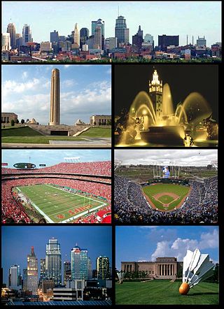
The Scout is a famous statue by Cyrus E. Dallin in Kansas City, Missouri. It is more than 10 feet (3.0 m) tall, and depicts a Sioux Indian on horseback surveying the landscape. The Scout was conceived by Dallin in 1910, and exhibited at the 1915 Panama–Pacific International Exposition in San Francisco, where it won a gold medal. On its way back east, the statue was installed on a temporary basis in Penn Valley Park. The statue proved so popular that US$15,000 in nickels and dimes was raised to purchase it through a campaign called "The Kids of Kansas City". The statue was dedicated in 1922 as a permanent memorial to local Indian tribes. It is located east of Southwest Trafficway in Penn Valley Park, which is south of downtown Kansas City.

Penn Valley Park is an urban park overlooking the Downtown Kansas City, Missouri.

Aubry Township is one of seven townships in Johnson County, Kansas, USA. As of the 2000 census, its population was 5,440.
Menorah Medical Center is an acute care hospital located in Overland Park, Kansas at 5721 West 119th Street. It is part of the HCA Midwest Division.

Homer Township is one of twenty-four townships in Bates County, Missouri, and is part of the Kansas City metropolitan area within the USA. As of the 2000 census, its population was 449.

Prairie Township is one of twenty-four townships in Bates County, Missouri, and is part of the Kansas City metropolitan area within the USA. As of the 2000 census, its population was 153.

Walnut Township is one of twenty-four townships in Bates County, Missouri, and is part of the Kansas City metropolitan area within the USA. As of the 2000 census, its population was 419.
The Blue Valley Sports Complex is a baseball, football, swimming and soccer complex located in Overland Park, Kansas. The complex is regularly home to the local high schools, Blue Valley North High School, Blue Valley Northwest High School, and Blue Valley West High School, and also held various games for Sporting Kansas City in 2001, 2004, 2006, and 2011.
Austin is an unincorporated community in Cass County, in the U.S. state of Missouri. It is part of the Kansas City metropolitan area.
Sni-A-Bar Township is an inactive township in Jackson County, in the U.S. state of Missouri. It was annexed into the city of Kansas City, Missouri and is within the Kansas City metropolitan area.
Washington Township is an inactive township in Jackson County, in the U.S. state of Missouri.

Bannister Road is a major east–west street in Kansas City, Missouri, US, replacing 95th Street. It stretches 10.9 miles (17.5 km) from State Line Road at the Kansas-Missouri state line in the west to Route 350 and Unity Village in the east. It continues west as 95th Street into Kansas, and east as Colbern Road into Unity Village and Lee's Summit.
References
- ↑ Rice, Glenn. "Former Kansas City International Raceway transforms into Little Blue Valley Park". The Kansas City Star. The Kansas City Star. Retrieved 22 July 2018.