The Arameans, or Aramaeans, were an ancient Semitic-speaking people in the Near East that was first recorded in historical sources from the late 12th century BC. The Aramean homeland, sometimes known as the land of Aram, encompassed central regions of modern Syria.
Carchemish, also spelled Karkemish, was an important ancient capital in the northern part of the region of Syria. At times during its history the city was independent, but it was also part of the Mitanni, Hittite and Neo-Assyrian Empires. Today it is on the frontier between Turkey and Syria.
Washukanni was the capital of the Hurrian kingdom of Mitanni, from around 1500 BC to the 13th century BC.

Aram was a historical region mentioned in early cuneiforms and in the Bible, populated by Arameans. The area did not develop into a larger empire but consisted of a number of small states in present-day Syria. Some of the states are mentioned in the Old Testament, Damascus being the most outstanding one, which came to encompass most of Syria. Furthermore, Aram-Damascus is commonly referred to as simply Aram in the Old Testament.
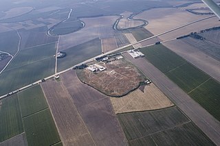
Tell Ta'yinat is a low-lying ancient tell on the east bank at the bend of the Orontes River where it flows through the Amuq valley, in the Hatay province of southeastern Turkey about 25 kilometers south east of Antakya, and lies near Tell Atchana, the site of the ancient city of Alalakh. Tell Ta'yinat has been proposed as the site of Alalaḫu, inhabited in late 3rd millennium BC, mentioned in Ebla's Palace G archive; and in later times as Kinalua, the capital city of an Iron Age Neo-Hittite kingdom. Among the findings are an Iron Age temple and several 1st millennium BC cuneiform tablets.

Tukulti-Ninurta II was King of Assyria from 890 BCE to 884 BCE. He was the second king of the Neo Assyrian Empire.

Tell Halaf is an archaeological site in the Al Hasakah governorate of northeastern Syria, a few kilometers from the city of Ras al-Ayn near the Syria–Turkey border. The site, which dates to the sixth millennium BCE, was the first to be excavated from a Neolithic culture, later called the Halaf culture, characterized by glazed pottery painted with geometric and animal designs.

The Kingdom of Aram-Damascus was an Aramean polity that existed from the late-12th century BCE until 732 BCE, and was centred around the city of Damascus in the Southern Levant. Alongside various tribal lands, it was bounded in its later years by the polities of Assyria to the north, Ammon to the south, and Israel to the west.

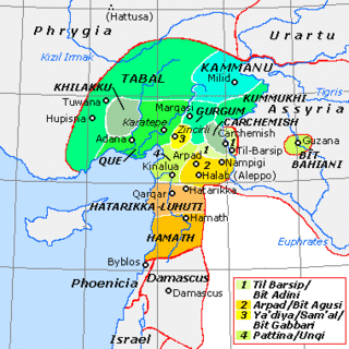
Sam'al, is an archaeological site located in the Anti-Taurus Mountains of modern Turkey's Gaziantep Province. During its time under the control of the Neo-Assyrian Empire it was called, by them, Sam'al. It was founded at least as far back as the Early Bronze Age and thrived between 3000 and 2000 BC, and on the highest part of the upper mound was found a walled citadel of the Middle Bronze Age. New excavations revealed a monumental complex in the Middle Bronze Age II, and another structure that was destroyed in the mid to late 17th century BC, maybe by Hititte king Hattusili I. This event was recently radiocarbon-dated to sometime between 1632 and 1610 BC, during the late Middle Bronze Age II. The site was thought to have been abandoned during the Hittite and Mitanni periods, but excavations in 2021 season showed evidence of occupation during the Late Bronze Age in Hittite times. It flourished again in the Iron Age, initially under Luwian-speaking Neo-Hittites, and by 920 B.C. had become a kingdom. In the 9th and 8th century BC it came under control of the Neo-Assyrian Empire and by the 7th century BC had become a directly ruled Assyrian province.
Tell Fekheriye is an ancient site in the Khabur river basin in al-Hasakah Governorate of northern Syria. It is securely identified as the site of Sikkan, attested since c. 2000 BC. While under an Assyrian governor c. 1000 BC it was called Sikani. Sikkan was part of the Syro-Hittite state of Bit Bahiani in the early 1st millennium BC. In the area, several mounds, called tells, can be found in close proximity: Tell Fekheriye, Ras al-Ayn, and 2.5 kilometers east of Tell Halaf, site of the Aramean and Neo-Assyrian city of Guzana. During the excavation, the Tell Fekheriye bilingual inscription was discovered at the site, which provides the source of information about Hadad-yith'i.
The states called Neo-Hittite, Syro-Hittite, or Luwian-Aramean were Luwian and Aramean regional polities of the Iron Age, situated in southeastern parts of modern Turkey and northwestern parts of modern Syria, known in ancient times as lands of Hatti and Aram. They arose following the collapse of the Hittite New Kingdom in the 12th century BCE, and lasted until they were subdued by the Assyrian Empire in the 8th century BCE. They are grouped together by scholars, on the basis of several cultural criteria, that are recognized as similar and mutually shared between both societies, northern (Luwian) and southern (Aramaean). Cultural exchange between those societies is seen as a specific regional phenomenon, particularly in light of significant linguistic distinctions between the two main regional languages, with Luwian belonging to the Anatolian group of Indo-European languages and Aramaic belonging to the Northwest Semitic group of Semitic languages. Several questions related to the regional grouping of Luwian and Aramaean states are viewed differently among scholars, including some views that are critical towards such grouping in general.
Til Barsip or Til Barsib is an ancient site situated in Aleppo Governorate, Syria by the Euphrates river about 20 kilometers south of ancient Carchemish.

Bit Adini, a city or region of Syria, called sometimes Bit Adini in Assyrian sources, was an Aramaean state that existed as an independent kingdom during the 10th and 9th centuries BC, with its capital at Til Barsib. The city is considered one of the two chief states of the Aramean-held territories in the Euphrates along with Carchemish.
A Bit-hilani is an ancient architectural type of palace. It seems to have become popular at the end of the tenth and during the ninth century BCE during the early Iron Age in northern Syria although it may have originated as early as the Bronze Age. Contemporary records call it a Hittite-style palace, probably after the Neo-Hittite kingdoms of northern Syria. This building type has also spread to the Southern Levant, where it has been widely used.

The Aramean flag or Syriac-Aramean flag is an Assyrian separatist ethnic flag designated for Aramean-identifying Assyrians. A first version, similar to the current one, was developed in 1980 by Bahro Suryoyo, a Syriac journal part of the Syriac Federation in Sweden. The current version was developed in early 1982.
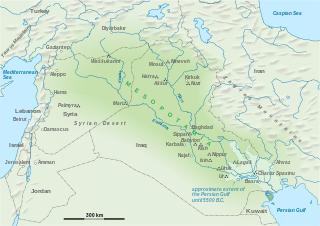
The Assyrian conquest of Aram concerns the series of conquests of largely Aramean, Phoenician, Sutean and Neo-Hittite states in the Levant by the Neo-Assyrian Empire. This region was known as Eber-Nari and Aram during the Middle Assyrian Empire and the Neo-Assyrian Empire.
Tell Aran is a Kurdish-majority town in northern Syria, administratively part of the al-Safira District of the Aleppo Governorate, located southeast of Aleppo close to Sabkhat al-Jabbul. Nearby localities include Tell Hasil, al-Nayrab and Tell Shughayb to the northwest and al-Safira to the southeast. According to the Syria Central Bureau of Statistics (CBS), Tell Aran had a population of 17,767 in the 2004 census. The town is famous for its grapes, vineyards and gardens. The number of residents of Talaar has exceeded 60,000, especially after the large numbers of people displaced from the city of Aleppo to it due to the bloody war in Syria. The affairs of the town of Talaran are managed through its municipality, which is elected by members of the Baath Party. Muhammad Shadi Murad is currently heading the municipality of Talaran, succeeding Mr. Haitham Hamam.

Zakkur was the ancient king of Hamath and Luhuti in Syria. He ruled around 785 BC. Most of the information about him comes from his basalt stele, known as the Stele of Zakkur.

Hittite art was produced by the Hittite civilization in ancient Anatolia, in modern-day Turkey, and also stretching into Syria during the second millennium BCE from the nineteenth century up until the twelfth century BCE. This period falls under the Anatolian Bronze Age. It is characterized by a long tradition of canonized images and motifs rearranged, while still being recognizable, by artists to convey meaning to a largely illiterate population.
“Owing to the limited vocabulary of figural types [and motifs], invention for the Hittite artist usually was a matter of combining and manipulating the units to form more complex compositions"
 Excavations in Tell Halaf, 1912
 Excavations in Tell Halaf, 1913
 A replica of the entrance to the palace of king Kapara at the National Museum of Aleppo
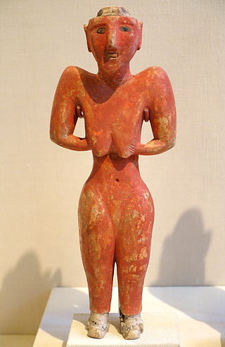
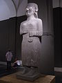 An Aramean goddess
 An Aramean god
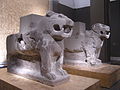 A stele depicting two guardian lions


